
 Continue with onX Maps
 Sign in with Facebook


| Elevation: | 689 ft | 210 m |
| GPS: |
42.07986, -90.75197 Google Map · Climbing Area Map |
|
| Page Views: | 76,887 total · 588/month | |
| Shared By: | Alan Grau on May 30, 2015 · Updates | |
| Admins: | Raud |
Description

Bouldering area located at the Joinerville boat ramp along the Maquoketa River. Limestone boulders featuring solid rock and fun movement on a variety of boulders. Problems range from vertical highballs to steep, juggy problems and a few tall, proud lines with hard moves on steep limestone.
You can park along the road inside the park. Please park closer to park entrance/approach trail. This will free up parking near the boat ramp for boaters.
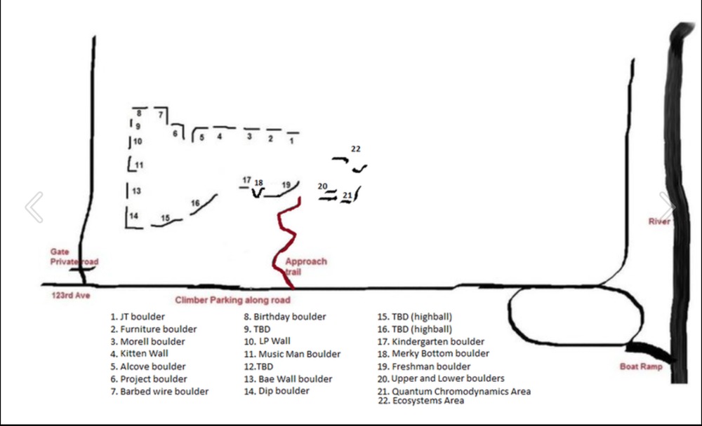
Bolting and roped climbing are not allowed at Joinerville.
Getting There
Joinerville park is located along the Maquoketa river in Jackson Country. Take Highway 64 west from Maquoketa for 4 miles. Turn right on 123rd Avenue (look for the Joinerville Canoe Access sign) and go 2 miles North on 123rd avenue to the park entrance.
Joinerville Park is open from 6:00 am – 10:30 pm for day use year-round. Camping is allowed by special permit and board approval only. Contact the Jackson Country conservation office for details.
Classic Climbing Routes at Joinerville Bouldering


Weather Averages
|
High
|
Low
|
|
Precip
|
Days w Precip
|
| J | F | M | A | M | J | J | A | S | O | N | D |
| J | F | M | A | M | J | J | A | S | O | N | D |
Photos

All Photos Within Joinerville Bouldering
Most Popular · Newest · RandomMore About Joinerville Bouldering
Printer-FriendlyWhat's New


6 Comments