Mountain Project Logo
To save paper & ink, use the [Hide] controls next to photos and comments so you only print what you need.

CM: Providence

Missouri
Warning Access Issue: Respect Private Property DetailsDrop down

Description

At this time, over one hundred established routes trace faint white lines up the variety of crags that tower near Perche Creek, the Eagle Bluffs Conservation ponds, and along the Missouri River. The ponds are often filled with ducks, geese, an occasional heron, and regularly surveyed by eagles from above. Ready made game trails see deer, possum, and fox traffic daily as they zigzag the base of many of the rocky cliffs. A good layer of trees offer a great buffer between the yoga stretching climbers and the bikes racing by, on the Katy Trail below. Hardwood foliage, provides shade through the summer months before bursting into warm fall colors. Autumn winds eventually scatter the impressionistic rainbow over the ground, allowing the winter sun to kiss the limestone grey, streak ridden walls by the afternoon. Towards sunset, the breeze seems to calm, the ducks really start to chatter, the still ponds reflect the orange glow of the heavens, and the reality of the days accomplishments truly starts to take hold. The Providence experience is truly like no other.

Rock Conditions

From Marcus Floyd,
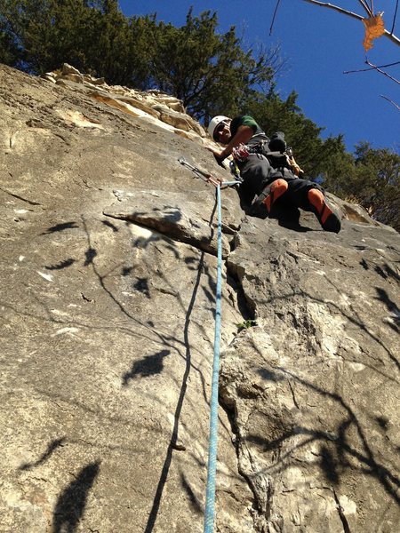
"Wow, was the first thought that went through my mind when I first found this jewel. The rock quality is quite good for more than a majority of the routes. Like most of the rock walls, along this stretch of the Missouri River, two horizontal chert bands divide the wall into two or three sections. Pockets of broken chert are just par for the course, in these parts! Belayers should stay alert and always wear a climbing helmet. It's not a bad idea to stand off to one side to avoid all possible rock fall."

Weather Conditions

Most Providence area cliffs receives plenty of sun, year around, so it dries very quick. Plan to experience great climbing conditions spring, fall, and winter, then beat the summer heat by planning to send these lines during the morning hours. Some shade trees provide shelter from the sun at many of the belay areas through the summer.

Getting There

From Columbia: drive south of Columbia on Providence about 5 miles until you come to a river access sign to Providence landing. Follow the access signs to the parking lot. Head east from the parking lot on the KATY trail. Less than half a mile to the bluffs. Scramble up a steep trail to the base of the bluffs.

Photos [Hide ALL Photos]

Slab Town Wall, Providence South
[Hide Photo] Slab Town Wall, Providence South
Jim Karpowitz and Mike Jenner on Turtle Head 5.9-, Turtle Head Wall, Providence North, mile marker 167
[Hide Photo] Jim Karpowitz and Mike Jenner on Turtle Head 5.9-, Turtle Head Wall, Providence North, mile marker 167
Climb the roots along the access trail to Providence Main Bluff
[Hide Photo] Climb the roots along the access trail to Providence Main Bluff
Artifact Wall and Fowl Slab Wall
[Hide Photo] Artifact Wall and Fowl Slab Wall
The Batress 5.8, Batress Wall, Providence North
[Hide Photo] The Batress 5.8, Batress Wall, Providence North
Marcus smearing on Say Hello To My Little Friend 5.8, Scarface Wall, Spire Area, Providence North
[Hide Photo] Marcus smearing on Say Hello To My Little Friend 5.8, Scarface Wall, Spire Area, Providence North
Scott Riley leading Artifact 5.7, Artifact Wall, Spire Area, Providence North
[Hide Photo] Scott Riley leading Artifact 5.7, Artifact Wall, Spire Area, Providence North
Buck getting the FFA of Primal 5.8, Primal Wall, Providence North
[Hide Photo] Buck getting the FFA of Primal 5.8, Primal Wall, Providence North
Fall is my favorite time to climb along the Missouri River
[Hide Photo] Fall is my favorite time to climb along the Missouri River
Marcus on Around Town 5.10d, Pocket Wall, Providence South Area, Columbia, MO
[Hide Photo] Marcus on Around Town 5.10d, Pocket Wall, Providence South Area, Columbia, MO
Geological features include spires and natural arches
[Hide Photo] Geological features include spires and natural arches
Perche Creek feeds into the Missouri nearby Providence Access boat ramp
[Hide Photo] Perche Creek feeds into the Missouri nearby Providence Access boat ramp

Comments [Hide ALL Comments]

James Dolph
Columbia, MO
[Hide Comment] i THINK you're referring to the line i sent back in 2008 called "Iron Clad 5.10a" (due to it's distinctive large iron deposit 1/2 way up the wall), re-named after it was bolted by Kevin Capps in 2010 "regurgitated bird 5.10c Dec 4, 2011
Jon B
Kittredge, CO
[Hide Comment] That big piece of iron/rock isn't there anymore. Not sure who took it out but it had to take some muscle! Dec 14, 2011
Marcus Floyd
columbia, mo
[Hide Comment] Word Feb 17, 2013
Ed Wade
Hermann, MO
[Hide Comment] The rock quality here is very sketchy. Don't forget your helmet. The approach is only about an 1/8 mi down the Katy trail. Very steep approach to the cliff base. Feb 23, 2016
Sam Pfeifer
Ellensburg, WA
[Hide Comment] Planning to stop by on a road trip and wondering where is the closest best free camping to this crag? Sep 8, 2019
Marcus Floyd
columbia, mo
[Hide Comment] Depends on your level of comfort required.
1) In the river flats along the trail
2) Car Camping
3) Hanging Bivy
4) Cooper's Landing (typically busy) Sep 22, 2019
Thomas Worsham
Youngstown, OH
[Hide Comment] Is lowering or rappelling the expected ethic for this area? Aug 28, 2021
Zane Winter
Kansas City, MO
[Hide Comment] Except in the most extreme circumstances, the ethic is to lower in sport areas. You will encounter the odd person who disagrees. Respond by pointing out that the vast majority of sport climbing accidents result from miscommunication on this front. It is always safer to lower. Sep 3, 2021