
 Continue with onX Maps
 Continue with Facebook


Routes in 2. Apron Area


|
Apron, The T 5.5 4b 13 IV+ 11 MS 4a |
|
|
Arete, The T 5.7 5a 15 V+ 13 MVS 4b |
Order Wrong?
Sort Routes
| Type: | Trad, 350 ft (106 m), 3 pitches |
| FA: | Bill Keiler, Jack Dorsey - 2010 |
| Page Views: | 985 total · 11/month |
| Shared By: | Ron Birk on Aug 23, 2016 |
| Admins: | Jay Knower, M Sprague, Lee Hansche, Jeffrey LeCours, Jonathan S, Robert Hall |
Your To-Do List:
Add To-Do ·
Your Star Rating:


Use onX Backcountry to explore the terrain in 3D, view recent satellite imagery, and more. Now available in onX Backcountry Mobile apps! For more information see this post.
Description

A fun little climb with a nice arete on the first pitch. It's a little dirty and could use some cleaning.
P1. Climb short steeper section with some gear to the start of the arete. Beware of a loose hold. Follow the arete passing a bolt and some easier terrain to a tree ledge and a pine tree on the right. The original belay was at an old almost dead questionable pine tree more in the left/center, so we moved the anchor (and added new webbing) to a nicer tree on the right. 5.5 120'
P2. Move through the trees to the next part of the cliff and climb easier featured terrain. Gear belay at a crack. 5.4 160’
P3. Over the bump and easy slab to tree ledge with rap anchor. There was no rap ring and only an old torn buried in the moss webbing when we got there so we added more webbing and left a biner. 5.2 70'
Once at the top, you can bushwack uphill to the next climb, The Arete. An outstanding route and the main reason for doing this route.
Descent: Two raps. The first one just barely reach to next tree ledge with double 60m, but the terrain is easy and safe at that point. Then go through the trees and a second rappel to the ground on climbers left (where you started the climb). Not sure if you can get down to the bottom of the actual cliff.
Location
GPS: N44.467750 W71.068743
To get to the Apron area, you have two options:
* The better is taking the trail that goes to October Sundae until it takes a sharp left (![]() ). At that point you can see the apron in front of you. Go straight ahead instead (towards the cliff) and you will very soon see a brook. You can follow it until it gets into the woods. At that point it's an easy short bushwack straight uphill right to the cliff. [June 2020 Update: I "reversed" these directions on a "exploratory hike around" and I think in the 4 years since Ron posted this, (2016) the growth in the logged-out area has become quite a bit thicker and higher. Be forwarned. R Hall NH Admin.]
). At that point you can see the apron in front of you. Go straight ahead instead (towards the cliff) and you will very soon see a brook. You can follow it until it gets into the woods. At that point it's an easy short bushwack straight uphill right to the cliff. [June 2020 Update: I "reversed" these directions on a "exploratory hike around" and I think in the 4 years since Ron posted this, (2016) the growth in the logged-out area has become quite a bit thicker and higher. Be forwarned. R Hall NH Admin.]
* You can also bushwack from the Lost Boys area along the cliff. It’s a little more work as the terrain is rough.
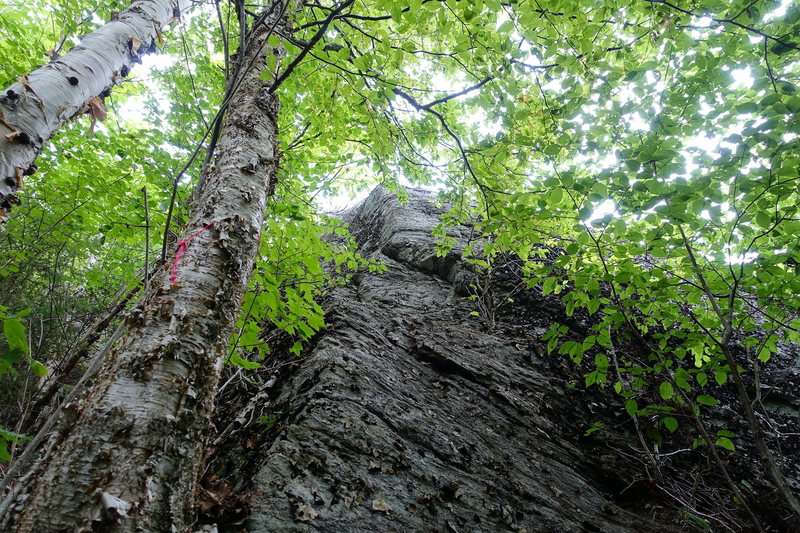
Once at the bottom of the cliff, the route is a little tricky to find and not obvious. It's located around on the left and uphill from the bottom part of the cliff. It's a steep hike. The start is by two birch trees (one of which has a pink string on it, Aug 2016) (![]() ).
).
To get to the Apron area, you have two options:
* The better is taking the trail that goes to October Sundae until it takes a sharp left (

* You can also bushwack from the Lost Boys area along the cliff. It’s a little more work as the terrain is rough.
Once at the bottom of the cliff, the route is a little tricky to find and not obvious. It's located around on the left and uphill from the bottom part of the cliff. It's a steep hike. The start is by two birch trees (one of which has a pink string on it, Aug 2016) (


1 Comment