
 Continue with onX Maps
 Continue with Facebook


Real Hidden Valley Rock Climbing
Use onX Backcountry to explore the terrain in 3D, view recent satellite imagery, and more. Now available in onX Backcountry Mobile apps! For more information see this post.
| Elevation: | 6,899 ft |
| GPS: |
39.74304, -105.34679 Google Map · Climbing Area Map |
| Page Views: | 21,128 total · 157/month |
| Shared By: | chinos Garlough on Apr 3, 2013 |
| Admins: | Leo Paik, John McNamee, Frances Fierst, Monty, Monomaniac, Tyler KC |
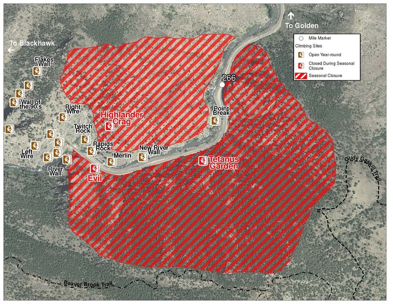
 Access Issue: Seasonal Raptor Closures/CDOT Road Work
Details
Access Issue: Seasonal Raptor Closures/CDOT Road Work
Details
Please be aware of the annual raptor seasonal closures!
Raptor Closures Effective February 1-July 31
Visit: jeffco.us/open-space/news/2…
Tunnel 1 closure
For more details visit: jeffco.us/open-space/alerts…
The two areas Jefferson County Open Space intends to close in Clear Creek Canyon, shown on the attached maps, encompass the active eagle nests. If the Clear Creek eagles continue to nest in the active nests, these areas will remain closed from February 1 through July 31. If the eagles choose different nesting sites, the closures will be adjusted accordingly to protect those eagles during their breeding season.
Currently, rock climbing areas that fall inside of the seasonal raptor closures include:
Blonde Formation
Bumbling Stock
Evil Area
Ghost Crag
Highlander
Skinny Legs
Stumbling Block
Tetanus Garden
Fault Caves
June 7, 2021 - TBD: Highway 6 is currently doing full road closures from Sunday night to Friday morning every week. The closure is from the junction of Highway 119 and Highway 6 to the junction of Highway 40 and Highway 6 (mile post ~260 to ~257). Vehicles that remain in the closure will be towed at owners expense.
Sundays: 7PM-4AM
Monday-Thursday: 4PM-4AM
Raptor Closures Effective February 1-July 31
Visit: jeffco.us/open-space/news/2…
Tunnel 1 closure
For more details visit: jeffco.us/open-space/alerts…

The two areas Jefferson County Open Space intends to close in Clear Creek Canyon, shown on the attached maps, encompass the active eagle nests. If the Clear Creek eagles continue to nest in the active nests, these areas will remain closed from February 1 through July 31. If the eagles choose different nesting sites, the closures will be adjusted accordingly to protect those eagles during their breeding season.
Currently, rock climbing areas that fall inside of the seasonal raptor closures include:
Blonde Formation
Bumbling Stock
Evil Area
Ghost Crag
Highlander
Skinny Legs
Stumbling Block
Tetanus Garden
Fault Caves
June 7, 2021 - TBD: Highway 6 is currently doing full road closures from Sunday night to Friday morning every week. The closure is from the junction of Highway 119 and Highway 6 to the junction of Highway 40 and Highway 6 (mile post ~260 to ~257). Vehicles that remain in the closure will be towed at owners expense.
Sundays: 7PM-4AM
Monday-Thursday: 4PM-4AM
Description

The Real Hidden Valley is a small crag 150 yards left of the Prestige World Wide Wall. The wall reminded me of climbing in Joshua Tree. The routes are roughly 65-70' tall with great exposure. The crag sits in a small ravine high up on the hillside a receives morning and afternoon sun. The routes are located on the left side of the wall.
Getting There
Park the same as Nightworm Pinnacle 8.0 miles up the canyon. It is across from the New Economy Cliff. Cross the road and follow a loose trail to the base of the Nightworm Pinnacle. Scramble around the right side of Nightworm and follow the wash to the right uphill past cairns.
Prestige Worldwide Wall will be hidden behind a large cedar tree on the left. The first part of the approach will be about 10 minutes uphill from the road. From PWW, walk left for ~10 minutes west if you basically contour at approximately the same level (passing along the base of some slabs) as the west (left) side of the crag. You can get a glimpse of the top of it pretty shortly after contouring west. Drop down into the ravine to the base of the crag.
Note, the Upper Wall is a bit higher up the hill, probably another 10 minutes and maybe another 400 yards uphill.
Classic Climbing Routes at Real Hidden Valley
Mountain Project's determination of the classic, most popular, highest rated climbing routes in this area.


Weather Averages
|
High
|
Low
|
|
Precip
|
Days w Precip
|
Prime Climbing Season
| J | F | M | A | M | J | J | A | S | O | N | D |
| J | F | M | A | M | J | J | A | S | O | N | D |


All Photos Within Real Hidden Valley
Most Popular · Newest · RandomMore About Real Hidden Valley
Printer-FriendlyWhat's New
Guidebooks (16)


11 Comments