
 Continue with onX Maps


ID 106529324 ·
·
Copyright Violation?


Rate Photo

 4.0
from
1 vote
4.0
from
1 vote
Mike Howard
Aug 28, 2009
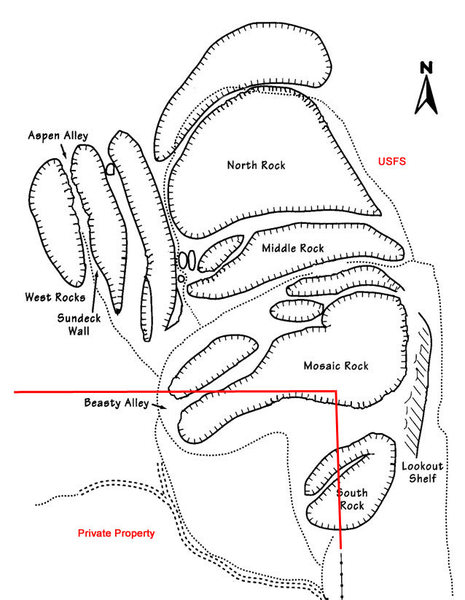
“Map:"The property line runs from approximately the current east corner by the access gate in a straight line over the top of South Rock to the top middle of the Chicken Heads/Mosaic Wall mount, and from there west down the mount slope to the meadow just south of the Alley climbs. Some of the most popular routes are completely on private property. There are survey markers on the top of South rock (the mysterious aluminum stake stuck in the rock) and on top of the Mosaic rock (most of the time buried in water in a pot hole.) The red line shows approximate boundry." as quoted from Jan Studebaker”


![The Land Owner requests this waiver to be signed and mailed if climbing on private property. Click (twice) to open this image in browser to enlarge and print. PDF Available for download as [[PDF]]http://lamountaineers.org/Tres_Piedras/Tres_Piedras_Route_Guide.html](https://mountainproject.com/assets/photos/climb/106533337_sqsmall_1494117894.jpg?cache=1701315936)


3 Comments