
 Continue with onX Maps
 Continue with Facebook


Mount Whitney: Mountaineer's Route, May Conditions?


|
I currently have a day permit for Whitney on 5/21. I have yet to climb Whitney and have been recommended by my other climbing friends to take the Mountaineer's Route instead of the Whitney Trail. Does anyone know what the conditions on the route will be like at that time considering the heavy amount of snowfall we had this past year? And how necessary it would be to take a rope up for the last 500 ft? |
|
|
Do you have experience climbing steep snow? Do you have self-arrest experience? Your question is really dependent on your experience and comfort level with steep snow/ice slogging at altitude after a pretty strenuous approach (skis? Snowshoes? tennis shoes?). I would bring crampons and ice axes at minimum. Here's the webcam that shows the current conditions on a macro level. http://www.whitneyzone.com/webcam/whitney.jpg Most folks do it in a couple days without a rope, but that is entirely condition/comfort/skill dependent. Take a look at this TR for some more objective details: http://www.summitpost.org/phpBB3/mount-whitney-in-may-t55961.html |
|
|
I've gone up the Mountaineers Gully wearing skis with climbing skins and then down it making nice turns with my skis -- with snow like what's likely later May this year -- but not wearing skis for the section above the top of the Gully to the summit (not sure if I used crampons for that section that time). By the way, I sort of doubt that it's legal to use your Mt Whitney Trail permit for the Mountaineers Gully. I doubt there will be a problem getting a North Fork permit for May 21 this year, but something to think about. Also "by the way" . . . Ken |
|
|
Also, I GIANT rock slide occurred on Whitney Portal Rd. Expected to open some time in May. Check with CalTrans |
|
|
Stephen Braucht wrote: The slide is cleared and the road is repaired. I have seen a couple of reports of people able to drive all the way to the trailhead without trouble in the past couple of weeks. (edit: but I do believe that the road is still technically "closed", however the gate isn't shut) |
|
|
I took my wife two teen daughters and 12 year old son up it last year early May and we hit snow and ice on the upper side of lower boyscout lake. No way you'll get past there without crampons and axes this year. |
|
|
I climbed the mr a couple of years ago in early June and we were on snow more or less from iceberg lake to the summit so with this years snowfall I would expect snow even lower. I definitely would take a ice axe and crampons. I would recommend that you be trained and comfortable with self arrest in case of a fall on snow and also be aware that doing this as a day trip you need to get a early start to try and catch good snow conditions so you don't post hole in the snow every step you take after the sun starts to warm the snow later in the day. Would be a long day but definitely worthwhile, this route is one of my favorites. |
|
|
To come back to this, we were up there as a team of 4 skiers last weekend (April 28-30). Conditions were generally good for skinning (or snowshoeing, if you're into that) all the way up to Iceberg Lake and the start of the route proper. The stream crossing near the ledges was the approach crux I'd say - maybe more so for you since it has likely melted further since our trip. But nothing too tough to figure out and time of day probably makes a difference. We did have to boot it up about a mile or so before we hit snowline by the way. The mountaineers route itself was in good condition with solid snow all the way up to the notch, with maybe a couple mixed moves necessary right near the top before the notch. Pretty straightforward though. Crux is probably not being stuck behind a huge line of people spraying ice down on you in the main chute. The final 400' did start with a couple exposed rock/mixed steps that then transitioned to hero snow to the summit. Watch for parties above you raining rocks and water bottles on you, as some idiots almost hit us with both on our climb. You can stay climbers right (away from the rock corner to the left) and avoid most of the potential rock hazard, but it is more exposed over there. Wind was also a huge factor for us but ultimately didn't change any of our plans/outcome. No rope needed but I could see why some may want a short, thin line to rappel those mixed rock sections noted above if they are uncomfortable down climbing it. We opted to descend from the summit via the optional class II traverse that eventually leads back to the notch, which turned out to be amazing and a welcomed option given the spicy moves the down climb would've required. When you get to the notch you will likely see the bootpack (directly in front of you as you get into the notch) leading climbers right of the standard climb up the final 400' - that's the traverse. Definitely go for it! Ryan |
|
|
Don't need snowshoes. No problem booting under current conditions |
|
|
^That webcam shot shows a lot of snow in the Mountaineer Route couloir^ Crampons and axe for sure. |
|
|
Ryan Maitland wrote: Thanks for the beta, Ryan! How did you find the class II traverse for getting down from the summit to the notch in terms of exposure, snow conditions, angle, etc.? On your way up the final 400', did you happen to see any fixed rap anchors? Any idea if a single 60m would be sufficient to rap the final 400' from the summit to the notch? |
|
|
FanZ wrote: When I did it in late April we rapped the final 400' (it was getting late in the day and we didn't like the looks of the down climb at that point). It took us 4 raps of a single 60m (i.e. ~30m raps) to get from the ridge to the notch. We left gear but I would imagine it's been reclaimed by now. |
|
|
Jared Casper wrote: Thanks Jared, that's helpful to know. Glad you guys made it down safely. |
|
|
Fan Zhang wrote: Sorry Fan, I didn't see this until just now. The traverse is the way to go on the decent without question. Of course the snow conditions are going to change so it is likely not smart to make that much of a blanket statement, but given the alternative downclimb it would be a pretty high hurdle to overcome for me if I were to do it again. And carrying a rope just to rap that seems like a poor alternative in my opinion. The exposure on the traverse isn't as bad as the final 400 as long as you're comfortable traversing steepish snow slopes in crampons. If you stay up toward the rock band (climbers right heading down to notch) there's a ton of room to self arrest before things get ugly. Certainly some no fall zones too but in my opinion not as bad as the final 400. A guy on our team actually did a front flip on the traverse for fun and didn't die. But that's not cool so don't do that, we gave him a ton of shit for it when we got to camp. i didn't see fixed gear anywhere but was away from the rock bands to keep clear of the rocks and water bottles sailing by. I've heard there is some, but you'd have to make the call on whether to trust your life to it. |
|
|
Ryan Maitland wrote: Thanks, Ryan. No worries. Your response is very helpful. We climbed the East Buttress last week and descended the final 400 via a combination of raps on fixed gear and down climbing. There was one really sketchy fixed rap anchor in the middle of the final 400 that we skipped, but down climbing at that point was pretty low key 3rd class. (I would have cut the fixed rap gear but was trying to get down ASAP because of a storm.) The final rap into the top of the notch was very helpful though. After getting down to the notch, I looked at the traverse and agree with your assessment that it didn't look too bad either, and no worse than other terrain that one encounters getting to the Mountaineer's Route. Who knows, it may even have been faster than the rappelling and down climbing the final 400. |
|
|
Ryan Maitland wrote: By "the traverse", do you mean ... |
|
|
kenr wrote: That's my understanding of what Ryan meant. Here's a photo of the traverse as of last Wednesday, looking at it from the notch (so looking west). 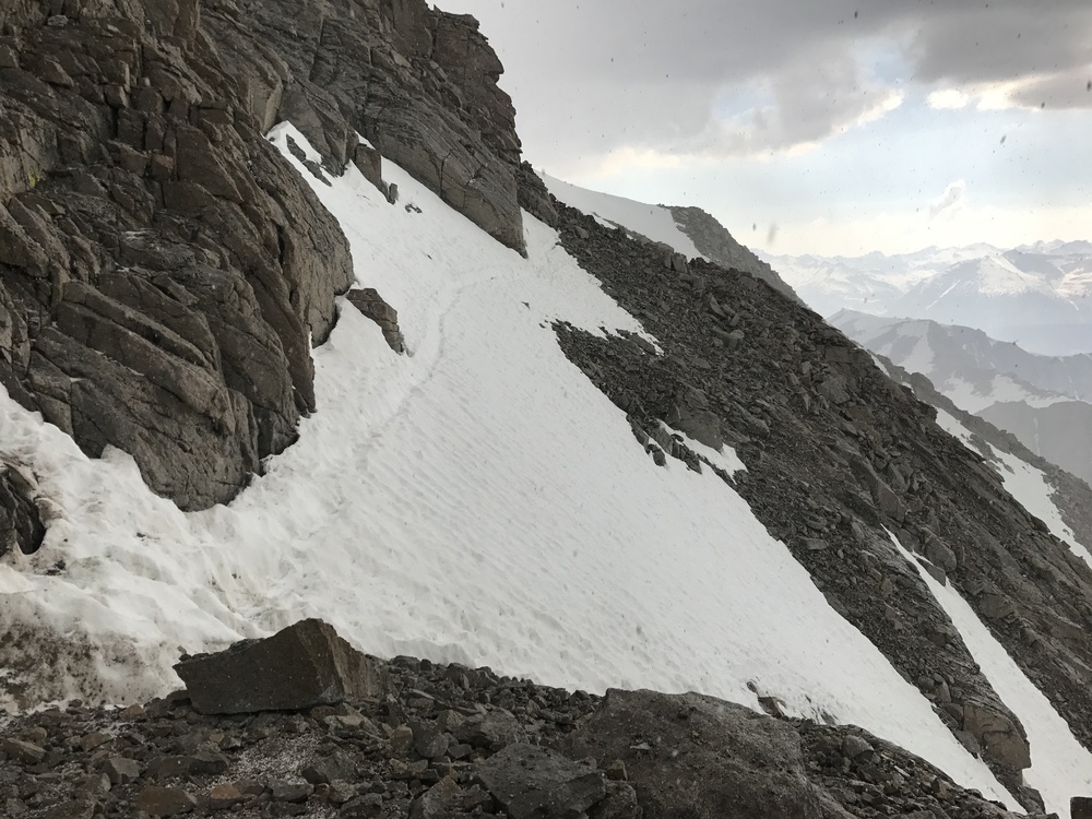 And here's more info on the traverse walk-off. |
|
|
Yep, that's it above. But man it looks way more thin than when we were up there! I'd still probably prefer that route versus hauling a rope and gear up the entire route for a couple awkward steps on the final 400. Or downclimbing that same terrain. |


