Continue with onX Maps
 Continue with Facebook


Half Dome hike, spring break


|
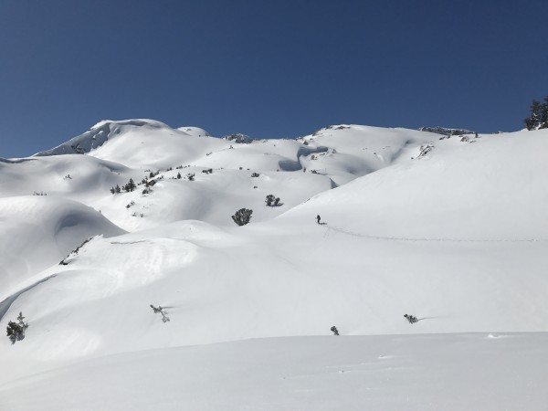
Chris Owen wrote:I was at the Glacier Point Hut last weekend - there was a lot of old snow, and by now a few inches of new snow. Personally I would not venture up Half Dome at this time.Serious question for those with more Yosemite winter experience than me. At least one person posted up above that you'd have to ski in from Badger Pass to get to the backside of Half Dome where the cables start. But as evidenced by the photo above, there's very little to no snow in the LIttle Yosemite Valley area (the area to the RIGHT of HD for those not familiar). I know the Mist Trail is closed for high water but the other JMT way up is open. Why wouldn't a person just hike up from the Valley? BTW, just to be clear, I STILL think it'd be an awful and potentially deadly idea to attempt the HD cables right now, even if you can get to them. |
|
|
AndrewArroz wrote: Serious question for those with more Yosemite winter experience than me. At least one person posted up above that you'd have to ski in from Badger Pass to get to the backside of Half Dome where the cables start. But as evidenced by the photo above, there's very little to no snow in the LIttle Yosemite Valley area (the area to the RIGHT of HD for those not familiar). I know the Mist Trail is closed for high water but the other JMT way up is open. Why wouldn't a person just hike up from the Valley? BTW, just to be clear, I STILL think it'd be an awful and potentially deadly idea to attempt the HD cables right now, even if you can get to them.You don't know quite what you are looking at. Look across from HD at the Snow Creek drainage to the left of Mount Watkins and to the right of North Dome with the image full size and zoomed. There is 10' of snow between 7-8000' even on south facing slopes. There is TONS of snow in little Yosemite Valley right now, though in the photo it is no longer in the trees so you don't see it, the trees are hiding it. Where the web cam image is taken today is about the same elevation that you have to get to, with more snow on the way. Also, the Panorama Cliff trail that you have to hike on to avoid the Mist Trail is north facing and has potentially lots of snow. If you zoom into the photo at full size you can see how much snow is at the base of the domes at the head of Little Yosemite too. Lastly, if you look at Half Dome's West Face at the level of the big snow patches in the older photo, that is how high you have to hike before you get to the cables. Compare that to the snow line around the Dome and you'll get a good idea what I am talking about. |
|
|
Thanks. Great explanation. King Tut wrote: You don't know what you are looking at. Look across from HD at the Snow Creek drainage to the left of Mount Watkins and to the right of North Dome. There is 10' of snow between 7-8000' even on south facing slopes. There is TONS of snow in little Yosemite Valley right now, though in the photo it is no longer in the trees so you don't see it. Where the web cam image is taken to day is about the same elevation that you have to get to, with more snow on the way. Also, the Panorama Cliff trail that you have to hike on to avoid the Mist Trail is north facing and has potentially lots of snow. If you zoom into the photo at full size you can see how much snow is at the base of the domes at the head of Little Yosemite too. Lastly, if you look at Half Dome's West Face at the level of the big snow patches in the older photo, that is how high you have to hike before you get to the cables. Compare that to the snow line around the Dome and you'll get a good idea what I am talking about. |
|
|
AndrewArroz wrote:Thanks. Great explanation.If my post is TL;DR: Just look at Mt. Watkins across from HD. When you are at the base of the cables you are looking **down** at the summit of Mt. Watkins across Tenaya Canyon. There may be some bare patches on the south facing stuff just above Little Yosemite. But eventually there is a shit ton before the cables. |
|
|
Honestly, Chris's photo shows much less snow than I expected. I bet it's pretty doable on that particular day. When we did it in May, there was much more snow on the slope below the cables than the May '11 pic King Tut shared, and the cables themselves were not sketchy in the least (no more than usual anyway). |
|
|
Rob Gordon wrote:Honestly, Chris's photo shows much less snow than I expected. I bet it's pretty doable on that particular day. When we did it in May, there was much more snow on the slope below the cables than the May '11 pic King Tut shared, and the cables themselves were not sketchy in the least (no more than usual anyway). If I had the gear winter gear, I'd be tempted to give it a burn.Go for it dude. But don't underestimate how much more snow there is now than at anytime you have been there. One photo can hide a lot of snow and bare patches mean little when the shady patches have 200% of normal on the ground. On the Mammoth to Yosemite ski that drainage is usually very assiduously avoided. It does get a lot of sun in little Yosemite and that makes for a nightmare ski of bare patches in the sun combined with deep snow in the shade. Can't be skied or hiked very easily when conditions are like that. |
|
|
|
|
|
This gives you an idea what is going on in the Park right now. |
|
|
These are some images south of Mammoth at around 11,000 published recently in the NYT: |
|
|
So you're saying maybe snowshoes. |
|
|
|
|
|
didnt this guy decide he wasnt going to do the hike 2 pages ago? |
|
|
Yes, but great web cam shots. |
|
|
Some people seem overly enthusiastic about the snow |
|
|
C Brooks wrote:Some people seem overly enthusiastic about the snowI love snow! :P |
|
|
Jake wander wrote:didnt this guy decide he wasnt going to do the hike 2 pages ago?He hasn't replied in 11 days, but that hasn't stopped people from posting. Very cool webcam shots, though, and some good discussion of this year's Sierra snowpack and the realities of winter backcountry travel. |
|
|
Long Ranger wrote:So you're saying maybe snowshoes. and a snorkel.I'm saying after 5 years of severe drought and the worst snow year in my lifetime last year I am thankful to see the Sierra return to their winter glory:   |
|
|
This was from December but very relevant. https://www.nps.gov/yose/blogs/a-winter-trail-run-to-half-dome-nearly-ends-in-disaster.htm |
|
|
Geordon B wrote: Thanks for posting that. Scary situation. Incredibly relevant. |
|
|
um......yea. And more on the way.    |