
 Continue with onX Maps


ID 109642755 ·
·
Copyright Violation?


Rate Photo

 5.0
from
2 votes
5.0
from
2 votes
Skip Harper
Oct 27, 2014
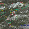
“BLAIR OVERVIEW:
A nearly 3D view of the Blair Area as seen from above. An arbitrary (yellow) line has been drawn to indicate how Upper Blair actually sits significantly higher than Lower Blair, making it quite easy to separate the two for identification purposes as well as their inclusive formations. Each (ie both 'Upper' and 'Lower' Blairs) will be treated separately at higher magnification with more detail on their respective pages.
Abbreviations:
Upper Blair: EC=East Corner, H=The Heap, JT=John's Tower, LJT=Little John's Tower, NC=North Corner, SC=South Corner, SMB=Spectreman Buttress, WC=West Corner.
Lower Blair: B1=Blair 1, B1a=Blair 1 Annex, B2=Blair 2, B3=Blair 3, GR=Goldirocks, LB=Little Blair.
#707=USFS Road 707.”


0 Comments