Continue with onX Maps
 Continue with Facebook


Descending Mt. Whitney Mountaineer's Route in Summer
|
|
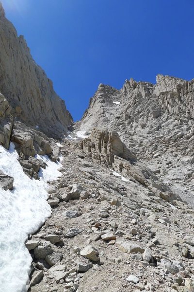
Going to be doing the Mountaineer's Route in late June for the first time. Doesn't look like there is going to be much snow if any around that time on the upper part of the route, but most of the descent information that I can find online seems to describe conditions with snow (post-holing and glissading), which won't concern my group. I am curious what the recommended descent is, or at least some information regarding the descent, for that time of year with those conditions might be (or is the standard to go up the MR and then down the regular trail?). Thanks. |
|
|
Jeff, |

|
I descended the MR after soloing the E Buttress mid-May. I didn't end up using my ice axe or crampons. There was another storm in the Sierra since then, but by the time you're going it will likely be all scree (bring helmets). |
|
|
p.s. Good place to get conditions reports for the Main Trail & MR: |
|
|
Hey everyone, thanks for the replies, I wasn't getting email notifications of them so I am just noticing them now... |
|
|
Like others have said it is the normal way to descend from going up the MR or the technical routes. Stay away from the cliff edges when descending to avoid possible rockfall. Chances are that you will take a ride on some scree at some point while descending. Once in a wile people mention bringing a rope for the MR for a few spots but if you pay attention to taking the easiest way that isn't necessary at all. |
|
|
Helmets are for rockfall kicked off by the line of people above you, which is more likely that you taking a spill if you pay attention. |
|
|
Thank you guys again for the good info! This is helpful since I know for sure that it won't be necessary to take the longer regular trail back to the bottom, adding unnecessary hours to the trip. |
|
|
Anyone? Anyone have any info on Horseshoe Meadows camping? Thanks. |
|
|
Hey, nothing on Horseshoe camping but I descended the Mountaineer's Route last week and it was bone-dry; bring your scree gaiters for sure, perfect conditions for some High Sierra Screeing! |
|
|
We just went up and camped on the road from Tom's Place (10000ft)and and slept somewhere with no problems. The mountaineer's route is a gully that follows the line of crappiest rock on Whitney. It is the neccesary way down, but I can't see why anyone would ascend that route. Just take the trail if you don't want to do the technical routes. There was a small soft heavily suncuppe snowfield at the bottom of the route May 30th. No ice axe and crampons required. |