
 Continue with onX Maps
 Continue with Facebook


Routes in The Oz

|
1st new route right of GBR [OZ NR1] S 5.9+ 5c 17 VI 17 E1 5a |

|
A1c S 5.10 6b 20 VII- 19 E2 5b |
|
|
Box Jellyfish S 5.10d 6b+ 21 VII+ 21 E3 5b |
|
|
Don't Touch This S 5.8 5b 16 VI- 15 HVS 4c |
|
|
Finding Dory S 5.6 4c 14 V 12 S 4b |
|
|
Finding Nemo S 5.5 4b 13 IV+ 11 MS 4a |
|
|
Gone Walkabout S 5.10a 6a 18 VI+ 18 E1 5a |
|
|
Great Barrier Reef S 5.9- 5c 17 VI 16 HVS 4c |
|
|
Oz NR2 S 5.9- 5c 17 VI 16 HVS 4c |
|
|
Oz NR3 S 5.8 5b 16 VI- 15 HVS 4c |
|
|
Oz NR4 S 5.10a 6a 18 VI+ 18 E1 5a |
|
|
Oz NR5 S 5.10c 6b 20 VII 20 E2 5b |
|
|
Oz NR6 S 5.10b 6a+ 19 VII- 19 E2 5b |
|
|
Oz NR7 S 5.10c 6b 20 VII 20 E2 5b |
|
|
Permit This S 5.10a 6a 18 VI+ 18 E1 5a |
|
|
Sea Anemone S 5.7 5a 15 V+ 13 MVS 4b |
|
|
Steve Irwin Memorial Arete S 5.11- 6c 22 VIII- 22 E3 5c |
|
|
Wes S 5.12a 7a+ 25 VIII+ 25 E5 6a |
Order Wrong?
Sort Routes
| Type: | Sport, 90 ft (27 m) |
| FA: | Greg Hand & Paul Heyliger |
| Page Views: | 2,302 total · 33/month |
| Shared By: | rob bauer on Aug 11, 2018 |
| Admins: | Leo Paik, John McNamee, Frances Fierst, Monty, Monomaniac, Tyler KC |
Your To-Do List:
Add To-Do ·
Your Star Rating:


Use onX Backcountry to explore the terrain in 3D, view recent satellite imagery, and more. Now available in onX Backcountry Mobile apps! For more information see this post.
 Access Issue: Seasonal Raptor Closures/CDOT Road Work
Details
Access Issue: Seasonal Raptor Closures/CDOT Road Work
Details
Please be aware of the annual raptor seasonal closures!
Raptor Closures Effective February 1-July 31
Visit: jeffco.us/open-space/news/2…
Tunnel 1 closure
For more details visit: jeffco.us/open-space/alerts…

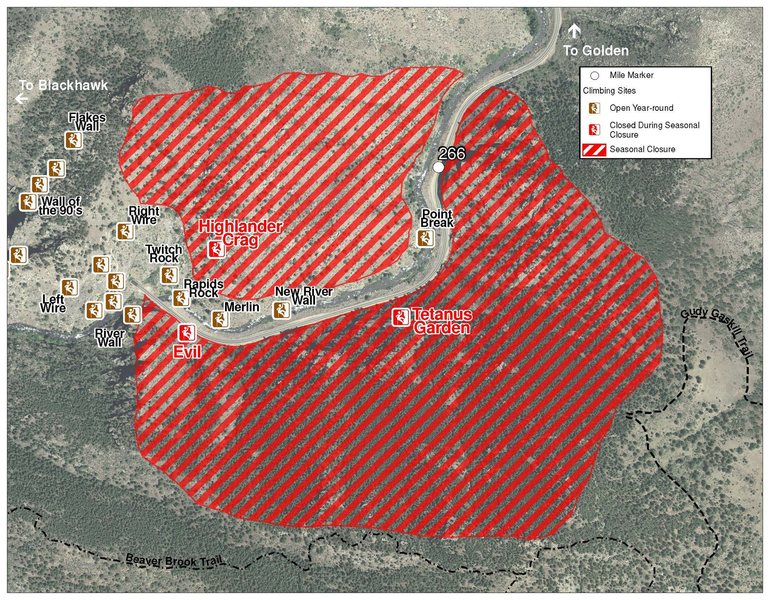
The two areas Jefferson County Open Space intends to close in Clear Creek Canyon, shown on the attached maps, encompass the active eagle nests. If the Clear Creek eagles continue to nest in the active nests, these areas will remain closed from February 1 through July 31. If the eagles choose different nesting sites, the closures will be adjusted accordingly to protect those eagles during their breeding season.
Currently, rock climbing areas that fall inside of the seasonal raptor closures include:
Blonde Formation
Bumbling Stock
Evil Area
Ghost Crag
Highlander
Skinny Legs
Stumbling Block
Tetanus Garden
Fault Caves
June 7, 2021 - TBD: Highway 6 is currently doing full road closures from Sunday night to Friday morning every week. The closure is from the junction of Highway 119 and Highway 6 to the junction of Highway 40 and Highway 6 (mile post ~260 to ~257). Vehicles that remain in the closure will be towed at owners expense.
Sundays: 7PM-4AM
Monday-Thursday: 4PM-4AM
Raptor Closures Effective February 1-July 31
Visit: jeffco.us/open-space/news/2…
Tunnel 1 closure
For more details visit: jeffco.us/open-space/alerts…
The two areas Jefferson County Open Space intends to close in Clear Creek Canyon, shown on the attached maps, encompass the active eagle nests. If the Clear Creek eagles continue to nest in the active nests, these areas will remain closed from February 1 through July 31. If the eagles choose different nesting sites, the closures will be adjusted accordingly to protect those eagles during their breeding season.
Currently, rock climbing areas that fall inside of the seasonal raptor closures include:
Blonde Formation
Bumbling Stock
Evil Area
Ghost Crag
Highlander
Skinny Legs
Stumbling Block
Tetanus Garden
Fault Caves
June 7, 2021 - TBD: Highway 6 is currently doing full road closures from Sunday night to Friday morning every week. The closure is from the junction of Highway 119 and Highway 6 to the junction of Highway 40 and Highway 6 (mile post ~260 to ~257). Vehicles that remain in the closure will be towed at owners expense.
Sundays: 7PM-4AM
Monday-Thursday: 4PM-4AM
Access Issue: Private Property - be aware & respectful
Details
Per Daniel Dunn, Stewardship Manager, Boulder Climbing Community ((803) 443-8822): this crag is on private property. The landowners are aware of the climbing on their property and continue to allow access for rock climbers. It is critical for long term access that everyone who climbs here is respectful and does their part to keep the crag in good shape. For more information on how to be a good steward, check out the Climber's Pact from Access Fund.
Description

This is the longest route at Upper Oz. It climbs up the left side of the fin and then moves around to the right at the top. The anchors are set back a bit, so you can't really see your partner if you belay up top (am I the only one who does that? Actually, I lowered, and it worked out ok). Big holds, lots of bolts, and good exposure equals fun. There's a few friable edges at this time, but they will clean up with a little more traffic.
Location
This is on Upper Oz.
This is currently the right-most route and climbs an obvious tall feature near the middle of this entire ledge. It starts in broken reddish-brown layers, moves up onto a grey slab, goes over right onto the side of the fin, and finally joins the main arete near the top.
Rap off.
This is currently the right-most route and climbs an obvious tall feature near the middle of this entire ledge. It starts in broken reddish-brown layers, moves up onto a grey slab, goes over right onto the side of the fin, and finally joins the main arete near the top.
Rap off.


1 Comment