Mountain Project Logo
To save paper & ink, use the [Hide] controls next to photos and comments so you only print what you need.

North Couloir (Engram Couloir)

5.6 AI2 Steep Snow, Trad, Ice, Snow, Alpine, 1400 ft (424 m), 5 pitches, Grade III,  Avg: 3.4 from 14 votes
FA: Al Fowler, Dan Eaton, Ron Cale (1972)
California > High Sierra > 08 - Bishop Pas… > Mt Gilbert

Description

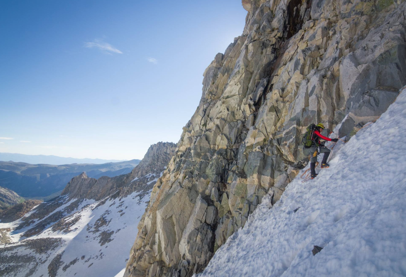
Following the obvious, steep breach of the montain's north face, this is a steep line offering pleasant exposure, with sustained 60-65 degree snow/ice portions. It stands as one of the steepest couloirs in the High Sierra, save for Ice Nine and Mendel Right. Depending upon the snow year, a bottleneck of rock half way up may involve a few simple mixed moves to surmount. Upon reaching the top of the couloir, either take the 5.6 chimney to the summit. Or drop 40 feet to the other side and enjoy a somewhat exposed, but extremely well-protected, 3rd/4th class ramp (looks like 3rd class, but in mountaineering boots climbs like 4th class)


Not the most straightforward peak to get off of, but nevertheless, one that can be done at the 2nd/3rd class level via Treasure Col. From the summit, follow the east edge/cliff of Gilbert heading southeast toward the obvious lowpoint breeching the ridge.  This breech point is Treasure Col. The descent down Treasure Col and down to the lakes of the same name is quite easy and without difficulty. It may involve some blocky 3rd class moves near the top. See the included photo in this album.  Other descent options may exist.

Approach

Access is most direct from the Bishop Pass Trailhead at South Lake.  Gilbert is visible from the trailhead, although assessing the couloir conditions will be difficult from here.  Head south along the trail toward Treasure Lakes (not Long Lake).  If camping, the most ideal place is Treasure Lakes given that the most obvious descent route is Treasure Col.  The lakes are the highest elevation common denominator between Gilbert and Treasure Col.


Once at Treasure Lakes, ascend the cirque 0.5-1 mile west of the one which is directly overlooking the lakes.  There may be faint use trails, probably a stream crossing, and a lot of 2nd class boulder hiking to ascend into the cirque.  Once there and looking down the far end of the cirque, Gilbert is on climber’s left.  Climber’s right is Thompson.

Protection

Singles up to #2, nuts, 1-2 pickets to manage rope around corners (if neve/Summer conditions), 8-12 ice screws (if climbing in Fall). Crampons, two ice tools.

Photos [Hide ALL Photos]

NB soloing high in the Engram Couloir, Mt Gilbert
[Hide Photo] NB soloing high in the Engram Couloir, Mt Gilbert
The North Couloir in late June, 2016.  Photo by climbing partner Emily Cheng.
[Hide Photo] The North Couloir in late June, 2016. Photo by climbing partner Emily Cheng.
The Engram Couloir seen in its true aspect on the way to the Harrington Couloir on Thompson in May 2012
[Hide Photo] The Engram Couloir seen in its true aspect on the way to the Harrington Couloir on Thompson in May 2012
Mt Gilbert at the North Couloir from a distance
[Hide Photo] Mt Gilbert at the North Couloir from a distance
Mt Gilbert at sunrise
[Hide Photo] Mt Gilbert at sunrise
Looking up the 3rd/4th Class rock section that takes you to the summit.
[Hide Photo] Looking up the 3rd/4th Class rock section that takes you to the summit.
Perfect conditions
[Hide Photo] Perfect conditions
At the top of the Couloir, September 2000. Michael Gordon photo.
[Hide Photo] At the top of the Couloir, September 2000. Michael Gordon photo.
looking up the couloir
[Hide Photo] looking up the couloir
Kelle Harter at the Summit registry of Mt Gilbert
[Hide Photo] Kelle Harter at the Summit registry of Mt Gilbert
Tim going up the first pitch
[Hide Photo] Tim going up the first pitch
This is the descent option mentioned in the photo with a X marking the top. There were a couple repel anchors on skier's left when we did it. Anywhere from 2-4 repels with 50m.
<br>
 (Photo taken 4 June 2021)
[Hide Photo] This is the descent option mentioned in the photo with a X marking the top. There were a couple repel anchors on skier's left when we did it. Anywhere from 2-4 repels with 50m. (Photo taken 4 Jun…

Comments [Hide ALL Comments]

Peter Cole
New Hampshire
[Hide Comment] Just one writers opinion, but having soloed this route twice, once in 1983 and again in 2012, I would venture that the angle found here is typical of most alpine couloirs in that it runs from 40-50 degrees. May 13, 2019
lperitz22
Berkeley, CA
[Hide Comment] We hiked up to this "couloir" on June 26 2022. Instead of finding any snow/ice, we encountered an almost entirely dry gully. It was shedding tons of loose rock, gravel, muck and appeared unclimbable. RIP sierra ice. Maybe a couple of high snow years in a row will restore this classic. Jul 27, 2022
Alois Smrz
Idyllwild, CA
  4th AI2 Mod. Snow
[Hide Comment] This can be really great one day round trip from the Trailhead at South Lake. The Couloir is not that sustained and can be easily soloed, even in hard ice conditions. Count on long day but ton of fun. There is really no need to climb any 5th class at the top, the 4th class scramble (described above) is about 100 feet long and on decent rock, even in mountain boots. Oct 28, 2023