To save paper & ink, use the [Hide] controls next to photos and comments
so you only print what you need.
East Ridge Direct
5.8-,
Trad, Alpine, 6 pitches, Grade III,

 Avg: 3.3 from 73
votes
Avg: 3.3 from 73
votes
FA: 1958 Fred Beckey, Joe Hieb, Ed Cooper, and Don Claunch
Washington
> Northwest Region
> Hwy 20 & N Casc…
> N Cascades
> Boston Basin
> Forbidden Peak
 Access Issue:
 Seasonal Raptor Closure at Newhalem Crags March 1st to mid-July
Details
Peregrine falcons select nest sites on cliffs in the Upper Skagit Valley, including the Climbing Management Areas of Newhalem West (Ryan’s Wall) and Newhalem East. As required in the NPS Superintendent’s Compendium, these areas will be closed to all public from March 1st to July 15th of each year, or until the young falcons have fledged or NPS staff have determined that nesting will not occur on a specific wall during this period. Access Fund, Washington Climbers Coalition and NPS partner on a volunteer raptor monitoring program to determine nesting activity. Contact the NPS and/or WCC for updates.
Description
A great alpine climb easily accessible (~4-5h from car park).
From camp, ascend north towards Forbidden's South Face. Reach a notch in the ridge and go left around the first gendarme. You'll reach a bivy spot where you can leave your boots+crampons,etc.
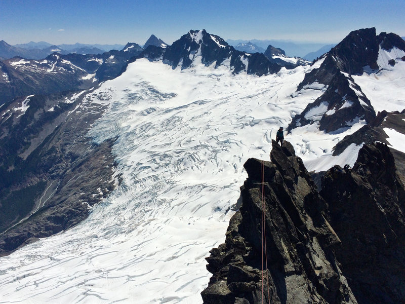
From the bivy spot climb a few pitches of low class 5. Climb up a second gendarme and knife edge ridge. After climbing the third gendarme you'll need to rappel into a narrow notch, there's plenty of tat. The third gendarme can be avoided by climbing around it on the north side. The second last pitch is the crux pitch, 5.8 (nothing difficult).
The great rock provides awesome holds.
Descent the north side by rapping and traversing climber's right. We made 5 rappels and simul climbed until we reached the bivy site where we stored our gear.
Location
Forbidden Peak, located in Boston Basin, east of Marblemount on the Cascade River Road
Protection
A set of cams, half a set of nuts (small nuts), lots of slings.
![The East Ledges from the North Ridge. Route in Red, Ledges in Yellow]()
[Hide Photo] The East Ledges from the North Ridge. Route in Red, Ledges in Yellow
![Near the top of the ridge on July 4th]()
[Hide Photo] Near the top of the ridge on July 4th
![Pretty cool setting.]()
[Hide Photo] Pretty cool setting.
![Exposure looking back at the ridge line from below the summit. The route goes up and over this knife edge, then a rappel into the notch.]()
[Hide Photo] Exposure looking back at the ridge line from below the summit. The route goes up and over this knife edge, then a rappel into the notch.
![Looking down on the belay from the top of the crux pitch. Can see the rap tat on the previous gendarme at the top of the photo.]()
[Hide Photo] Looking down on the belay from the top of the crux pitch. Can see the rap tat on the previous gendarme at the top of the photo.
![Traversing roughly halfway through the route.]()
[Hide Photo] Traversing roughly halfway through the route.
![Near the start (X) of the east ridge in August 2019. There were some moderate snow slopes below where this photo was taken--approach shoes and aluminum crampons (without glacier rescue gear) would have worked. (Photo: Mark F.)]()
[Hide Photo] Near the start (X) of the east ridge in August 2019. There were some moderate snow slopes below where this photo was taken--approach shoes and aluminum crampons (without glacier rescue gear) would…
![Rapping down the East ledges]()
[Hide Photo] Rapping down the East ledges


 Continue with onX Maps
 Continue with Facebook


Seattle, WA
Note that you can bypass both Gendarmes on the right/east side. Done this way the whole climb can go at 5.6 or so.
Have your descent figured out!! There's no easy way off Forbidden, so whether you descend the East Ledges, or downclimb the West Ridge (or some more obscure option), when you reach the summit, you are no more than halfway through your day. Aug 25, 2011
Stone Ridge, NY
Denver, CO
Boulder, CO
Kent, WA
We did a carry over with our boots/pointy bits and simul climbed down the west ridge as the east ledges were thinly snow covered and quite sketchy. This made for a much more interesting alpine climb than late in the year when you're doing more choss dodging. You'll get some steep snow, if it's nearly melted out maybe some mixed climb stemming to get up a vertical moat too :) Jul 5, 2016
Auburn, WA
We descended the East Ledges, which are not as dramatic as everyone makes them out to be. I will say, that it is a no fall zone and there is plenty of loose rock on it. There are 5 raps, each of which are between 25-30 meters, don't quit rapping too soon. Scramble and traverse a series of sandy, grassy ledges for several hundred meters until you see the first gendarme. Once you reach the gully, simply ascend 4th class blocks to the beginning of the route, no need to actually enter that loose gully. Descent took ~2 hours unroped from the last rap. Jul 6, 2016
Beaverton, OR
Seattle, WA
Crux are 2 river crossings, due to volume of water.
Route itself is pretty much a scramble, with about 40 ft of real climbing. Crux is way easier then 5.8- more like 5.6, with good gear at the waist- literally 3 moves. Mostly it's just exposed ridge scrambling.
Raps to East ledges have nice slings and rings, rope falls clean. Ledges are snow free, still a bit of snow in the gulley to get back up, but you don't have to touch it. Jul 16, 2020
Indiana
New York, NY