To save paper & ink, use the [Hide] controls next to photos and comments
so you only print what you need.
La Facada Norte
5.9 PG13,
Trad, 140 ft (42 m),
 Avg: 1 from 1
vote
Avg: 1 from 1
vote
FA: Al Simons-James Barnum
Colorado
> Estes Park Valley
> Big Thompson Ca…
> Beige Tube Area…
> Ironing Board Slabs (…
 Access Issue:
 Access issue - Monastery, Cedar Park, Combat Rock, etc. - open since 2023
Details
Update: per Bruce Hildenbrand: the area has been open since 2023. Per
JF M: as of May 2022, there is no signage on-site, nor information on the USFS webpage for the Cameron Peak Fire (nor on their published map of closures) that indicates the area is closed.
Per
Bruce Hildenbrand: it appears that the Forest Service has closed access to all the climbing areas accessed via Storm Mountain Road (Monastery, Cedar Park, Combat Rock, etc.) until they can clear all the dangerous dead trees from the Cameron Peak fire.
I worked this issue with Eric Murdock at the AF, and it looks like the Forest Service picked Devil's Gulch Road as the southern boundary even though all the climbing areas on MP.com were not burned.
Description
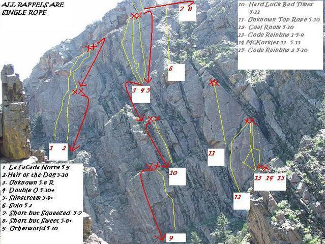
Start under the bolt and pull up gaining a small ramp (5.8). Head for the next bolt 40 feet up picking your way thru a series of slabby dihedrals placing small gear. Gain a third bolt and the big, left-facing corner (good gear to two inches (5.5) to the RIGHT side of a roof system. Clip the bolt and pull the right side of the roof (7+) to a stance and the last bolt. Head up and right to a V-shaped slot (run out 5.9) to the anchors.
Location
Big T Canyon. Park 0.6 miles west of the beige siphon tube. Option 1. Walk east up the road (Hwy 34) and forth class up the hill side 200 feet at about the 0.4-0.5 mile mark. Head for a large pine tree at the base of the route. Option two. Park 0.6 miles west of the tube, back down the road to the 0.4 mile mark and hike up a steep gully that intersects with the ridge. Follow that up to the the north end of the upper ridge, traverse down then up to the large, sloping ramp. Rap off of the anchors next to a tree (same as for
Hair of the Dog) to the base. Route starts 10 feet right of a huge pine tree under the bolt. Climb is on the upper left end of the slabs 60 yards left of
Double O and 10 yards left of
Hair of the Dog on a north-west facing wall. Descent- raps off of
Double O Slab or traverse down approach gully to road.
Protection
5 bolts and gear 0.3 to 2 inches. Two bolt anchor at top shared with
Hair of the Dog.
![All of the Ironing Board Slabs uphill from the 0.6 mile mark Big T Canyon.]()
[Hide Photo] All of the Ironing Board Slabs uphill from the 0.6 mile mark Big T Canyon.


 Continue with onX Maps
 Continue with Facebook


Loveland, CO