To save paper & ink, use the [Hide] controls next to photos and comments
so you only print what you need.
Chuckwalla 21
5.9 PG13,
Trad, 900 ft (273 m), 6 pitches, Grade IV,
Avg: 3.3 from 18
votes
FA: George,Joanne Urioste, Joe Herbst
Nevada
> Southern Nevada
> Red Rocks
> (17) Mud Spring…
> Global Peak
Access Issue: Red Rock RAIN AND WET ROCK: The sandstone is fragile and is very easily damaged when wet.
Details
Holds rip off and climbs have been and will continue to be permanently damaged due to climbers not respecting this phenomenon. After a heavy storm, the rock will remain wet, sometimes for several days. PLEASE DO NOT CLIMB IN RED ROCKS during or after rain. A good rule of thumb is that if the ground near your climb is at all damp (and not powdery dry sand), then do not climb. There are many alternatives (limestone, granite, basalt, and plastic) nearby.
HUMAN WASTE Human waste is one of the major issues plaguing Red Rocks. The Las Vegas Climbers Liaison Council and the AAC provides free "wag bags" in several locations (Black Velvet, First Pullout, Kraft Mtn/Bouldering, The Gallery, and The Black Corridor). These bags are designed so that you can pack your waste out - consider bringing one to be part of your kit (just like your rope and shoes and lunch) no matter where you go. Once used, please dispose of them properly (do not throw them in the toilets at the parking area).
Description
I climbed this route with Killer Killis and never lacked for conversation:)
1st pitch goes up a right-facing flake with a bolt about 20 feet above the top of the flake. Three bolts in all. 150ft
2nd pitch goes straight up following numerous bolts. Be careful some hollow flakes but you can pick your way safely. 160ft
3rd pitch follow corner to a left-facing corner. 130ft
4th pitch goes straight up to a finger crack. Near the top take the crack on right 30 feet to bolted anchor, will be on your left on the dihedral. 160ft
5th pitch up to a ledge with some large bushes. 150ft
6th pitch fly up easy terrain to the top of summit. 120ft
All anchors are bolted with the exception of the summit. There you'll find a cordelette around a tree with fixed nuts. Rappel using two 55 M ropes.
This climb took us 4 hours to ascend and descend. The approach took us 3 hours in and 3 hours out. The approach is tricky and requires high exposed scrambling. We saw and got very near a herd of Big Horn Sheep which got spooked and scrambled away above us creating an avalanche of rock. BE CAREFUL!
Location
Approach as Black Velvet Canyon taking first dirt road on left to head towards Mud Springs Canyon. Park and head into canyon going for vegetated break in cliff band on right side. Look for cairns to avoid B W 4 (the bushwhack sys.)Go up and right and then back left on ledges then down slabs to top of water fall slabs. From there take the right larger gully up to a point where you can scramble up steep slabs to ledges. Go up and right and then back left to get to base of climb along a ramp. Look for right-facing flake of first pitch. Climb starts off a window-box-like bench. You can scramble down the same way or scramble down right to same large gully you came up before, but further in. You'll encounter large boulder hopping with one requiring a rappel. (fixed sling). There are numerous cairns; thanks to Killis for pointing the way.
Protection
Standard rack up to #3 Camalot with doubles from .5" to 2" Camalots. Small gear required for thin cracks also. We found ballnutz useful.
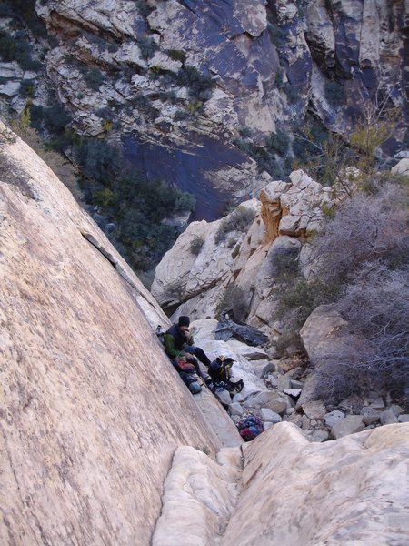
[Hide Photo] The summit of Chuckawalla 21 (Global Peak) is amazing; Well worth the hike, and climb. With a late start we did the entire hike out in the dark; no problem; That's what headlamps are for. ; )…
[Hide Photo] The route starts up the nicely shadowed right facing vertical flake seen near the lower left corner of the photo. When I get some time I'll photoshop the line in. Great route with a beautiful, thou…
[Hide Comment] I think that a couple of details might help out on the approach -- I cairned as heavily as I could while attempting to keep up with Mountain Goat Mike, but with the length of the hike in, every bit of beta you have will make life easier.
When parking, you have the option of the Black Velvet lot or follow the less-traveled high-clearance 2WD road towards the Windy Peak parking -- take a left before you come to the fence that marks the turn towards BV and head towards Mud Springs Canyon (SuperTopo book photos helped us here). We chose the latter. If coming from BV, STAY LOW!. Walk left, following the usual sorta-trail until you hit the entrance to MSC. Using either approach, they merge here, dropping into a wash that avoids the worst scrub oak. Follow the wash, exiting as you pass under attractive varnished cliffs on your right not far from where the canyon opens up. Follow a good, obvious red dirt trail that leads to an obvious break in the soft pink cliffs (Chinle formation). Climb up and follow ramps right, following intermittent cairns to a short boulder problem easiest to pass on the left (vegetation crushed down). Cairns begin in earnest as you cut left under a "turtle head" formation on the main varnished cliff wall (tan-brown rock) and dodge cacti until a large bowl opens up in front of you, necessitating a sharp right turn through a narrow constriction that descends, following closely to the canyon wall on your right. There is an attractive gully system on the left when you reach sets of double cairns on a large flat terrace -- DON'T TAKE IT. Stay in the broad but bushy wash on the right, following cairns for several hundred more yards.
When the canyon narrows to about 20ft wide and the walls look steeper, be on the lookout for a cream-colored right-facing corner on your left side that looks chossy. This is your shortcut -- Mike and I put several large cairns there, and it is a really nice alternative to the 5th class boulder problems just ahead. You'll know that you passed this corner if you hit anything taller than you that looks like a grunt to climb. We rap-descended the "boulder problems" on the way back down, and it was the slowest we moved all day. Better to climb and descend the 4th-class corner -- waay easier than it looks. Once at the top of the corner, head straight right, turn the corner, and look for the climbs just above you.
If going up the boulder problems, machete your way through oak bushes, scrambling quite a bit with the occasional 5th-class move thrown in for good measure. Good luck, hope the cairns help! If you use the wash going in and don't get lost, a sub-3 hour time is entirely possible, but plan on 3-4 hours for your first time out there.
Mar 22, 2007
[Hide Comment] Jon Cheney (aka The Cat) and Michelle Onsaga and I did this awesome route Memorial Day 5/26/08. The route was in the sun all day until probably 3pm when we were rappeling.
The first 2 pitches are a tad runout, but the few 5.9 moves are all right next to bolts or great pro. The third pitch is more like 110' and the last two pitches are mostly scrambling so with all the bolted belays, the route goes VERY fast.
The main difficulty of the route is the tricky route finding of the approach, which is actually very beautiful. I will hopefully post pics soon. With pictures to back up Mike and Killis' directions, the mystery of Chuckwalla 21 will soon be revealed...
May 28, 2008
[Hide Comment] A few pointers that may help you find the start of the route.
1. Chuckawalla starts high up on the left flank of Global Peak. Wayyyy left.
2. There is a slot canyon/gully that enters the left side of the main drainage just before a rather tallish boulder blocking the entire main drainage. We scrambled up this gully. Where it hits the top of the buttress we countoured left. You will pass a rap station (tree with some cord). Remember this as it will expedite your retreat. Continue left past the rappell anchor and scramble up another 'boulder problem' Start countouring back to the right across a loose talus field. You will eventually hit the gully at the base of Global Peak proper. DO NOT DESCEND THE GULLY. Go up the gully (left) to the start of the climb. Handren describes Sidewinder as the most prominent feature on this face. It is most definitely not. If you descend the gully to view the right side of Global Peak there are several prominent lines of weakness. This discrepancy added at least an hour to our approach.
Oct 19, 2010
[Hide Comment] Approach for this climb was far more straightforward than expected.
1) The passage through the red rock band (Chinle) is extremely obvious. After this, just head for the Turtle Head roof and get onto the highest ramp that rises up and left.
2) When you reach the notch above the pools, stay high on the right to avoid having to regain elevation. The ledge system is well marked with cairns and deposits you on the slabs at the entrance to the narrow part of the canyon.
3) The suggestion to climb the yellow, chossy, right-facing corner before the 5th class waterfall is a good one. It's a full rope length and significantly easier than the 5th class climbing ahead. The climb is more or less directly above you at this point, After 200 ft of climbing (when the corner ends), just follow the path of least resistance right to get into the left-rising bushy gully that leads to the climb.
Note: There was no water at the supposed "5th class waterfall" in April 2011. The last water was at the pools where you enter the narrow part of the canyon.
Apr 26, 2011
[Hide Comment] I think this was a 2 star climb in a 4 star setting, so I gave it 3 stars. The line is really cool, the summit is amazing and the climbing is fun, but there is a predominance of hollow flakes on every single pitch.
I'm pretty stingy with R ratings but thought the 1st and 5th pitches were runout. I would not reccomend the first pitch for someone new to Red Rock or leading at their limit. The climbing on the 5th pitch is quite easy, but there is one steep section that is almost all hollow rock and no pro(although I didn't look around to much).
We did Branch's hike(seemed much more direct and straightforward and was well cairned) to Killis's shortcut(we also downclimbed this on the way out, might want to consider rapping this section) and the approach took us 1:50.
Here is a breakdown of the approach:
1) Take the dirt road from the paved parking lot towards black velvet, take the first left then park at a pullout next to the wash that goes into mud springs canyon.
2) Go down the hill into the wash and hike towards the canyon staying to the right side of the wash, at times it's a mountain bike trail, a hikers trail, no trail until you get to some large boulders towards the mouth of the canyon.
3) Pick up a decent trail at the boulders that continues on the right side of the wash eventually dropping into the wash.
4) Work your way up the wash and exit these 3rd/easy 4th class ramps and go up:
6) Continue to top of saddle, then follow trail down to a 3rd class down climb into main wash. Head up this wash until you reach Killis's shortcut(his description is perfect, but the cairns were gone so I built a new one)
We ended up going car to car in 9 hours at a efficient but pretty relaxed pace.
[Hide Comment] Thanks for all the info here but some basics are missing and without any pics in our printout that requested beta pics we had some issues finding this one. There are cairns everywhere - maybe some are canyoneering back here now? Anyway you need to approach this route from the northwest to do that you are go up the north fork of Mud Springs. The canyon is blocked by a waterfall so a couple of hundred yards prior (East) you need to skirt around to South (good beta pic for where that is). You go over a pass and drop a little before re-entering the wash. Very shortly the boulder problems and short-cut described will be obvious. We scrambled up short-cut and did an easy rap down the boulder probs on way out. Route is pretty central (again pic would have helped!) not on the wayyyy left - I know I went there! I did not use the 'flake' at all on the first pitch climbed corner and face left of it to the top of it. Climbing is great but rock is not as good as most RR classics - don't even consider if there's been recent rains! Thanks ASCA for the new bolts!
Apr 10, 2013
[Hide Comment] A fun and engaging route, made all the better by the adventurous and beautiful location.
We were a little confused at the start, but eventually realized that the shallow, right-facing "flake" in the middle of the face was the key feature. The pitch ends just past some great black varnish on a ledge, and if you squint you can make out a couple of bolts.
I also moved left of the flake, before coming back over it heading right.
Take heart, there is more gear than it looks like there will be. Where it is heads up, it's 5.5, so it feels bolder than it really is.
Apr 13, 2015
[Hide Comment] Approach: As you near the red cliff (Chinle Formation), there's a slightly confusing trail junction with cairns leading (1) down into the main wash, (2) straight ahead, and (3) uphill to the right. The ones on the right, which don't seem as obvious, lead to the long switchback north and back south described in Supertopo; the ones straight ahead lead to a third or fourth class slab that cuts out the switchback. No idea where the cairns down and left take you.
Closer to the climb, going up the yellow, chossy-looking corner on the left before the "boulder problem" waterfall, and descending the main drainage with one short rappel, worked well for us. The only water was in the pools at the mouth of the slot canyon.
As of late April 2015, birds (canyon wrens?) are actively nesting in a hand-jam-sized slot in the crack on the fourth pitch, maybe 50' above the belay. The nest is easy enough to avoid if you know it's there, but you can't see it from below.
We replaced the sad collection of tat on the summit rap anchor, so the tree and the two fixed stoppers are currently rigged with tied off and equalized 7mm static line.
Due to the remoteness and the rock quality, this climb has an overall serious feel to it, despite the moderate difficulty and adequate protection. A standard rack to #3 Camalot worked well for us, with Tricams and thin cams getting plenty of use.
Apr 22, 2015
[Hide Comment] Just to reiterate, this climb loses much of its "seriousness" if you carry a #1-3 Ballnut set. Mike M was a Ballnut skeptic before this climb, after solid placements that really cut down on the runouts on the first 2 pitches, he was sold on them.
Apr 22, 2015
[Hide Comment] Agree on the Ballnuts. We didn't take them, but there were obvious spots where they would have worked well, especially before reaching the bolts on the first pitch.
Apr 22, 2015
[Hide Comment] Not sure what all the 3-4hr approach hubbub is about, I guess some people get REALLY lost up there. Took us 1:30 to the base first try following Supertopo beta without any shortcuts. Seemed pretty straightforward with some routefinding skills. Ample time for a swim in the pools afterward AND climb the Schwa on the way out, all well before dark. Fun route, but hardly a classic. Ball nuts didn't seem to provide any additional protection that small stoppers couldn't match.
May 31, 2016


 Avg: 3.3 from 18
votes
Avg: 3.3 from 18
votes
 Access Issue: Red Rock RAIN AND WET ROCK: The sandstone is fragile and is very easily damaged when wet.
Details
Access Issue: Red Rock RAIN AND WET ROCK: The sandstone is fragile and is very easily damaged when wet.
Details

 Continue with onX Maps
 Continue with Facebook


When parking, you have the option of the Black Velvet lot or follow the less-traveled high-clearance 2WD road towards the Windy Peak parking -- take a left before you come to the fence that marks the turn towards BV and head towards Mud Springs Canyon (SuperTopo book photos helped us here). We chose the latter. If coming from BV, STAY LOW!. Walk left, following the usual sorta-trail until you hit the entrance to MSC. Using either approach, they merge here, dropping into a wash that avoids the worst scrub oak. Follow the wash, exiting as you pass under attractive varnished cliffs on your right not far from where the canyon opens up. Follow a good, obvious red dirt trail that leads to an obvious break in the soft pink cliffs (Chinle formation). Climb up and follow ramps right, following intermittent cairns to a short boulder problem easiest to pass on the left (vegetation crushed down). Cairns begin in earnest as you cut left under a "turtle head" formation on the main varnished cliff wall (tan-brown rock) and dodge cacti until a large bowl opens up in front of you, necessitating a sharp right turn through a narrow constriction that descends, following closely to the canyon wall on your right. There is an attractive gully system on the left when you reach sets of double cairns on a large flat terrace -- DON'T TAKE IT. Stay in the broad but bushy wash on the right, following cairns for several hundred more yards.
When the canyon narrows to about 20ft wide and the walls look steeper, be on the lookout for a cream-colored right-facing corner on your left side that looks chossy. This is your shortcut -- Mike and I put several large cairns there, and it is a really nice alternative to the 5th class boulder problems just ahead. You'll know that you passed this corner if you hit anything taller than you that looks like a grunt to climb. We rap-descended the "boulder problems" on the way back down, and it was the slowest we moved all day. Better to climb and descend the 4th-class corner -- waay easier than it looks. Once at the top of the corner, head straight right, turn the corner, and look for the climbs just above you.
If going up the boulder problems, machete your way through oak bushes, scrambling quite a bit with the occasional 5th-class move thrown in for good measure. Good luck, hope the cairns help! If you use the wash going in and don't get lost, a sub-3 hour time is entirely possible, but plan on 3-4 hours for your first time out there. Mar 22, 2007
Las Vegas, NV
The first 2 pitches are a tad runout, but the few 5.9 moves are all right next to bolts or great pro. The third pitch is more like 110' and the last two pitches are mostly scrambling so with all the bolted belays, the route goes VERY fast.
The main difficulty of the route is the tricky route finding of the approach, which is actually very beautiful. I will hopefully post pics soon. With pictures to back up Mike and Killis' directions, the mystery of Chuckwalla 21 will soon be revealed... May 28, 2008
Ridgway, CO
1. Chuckawalla starts high up on the left flank of Global Peak. Wayyyy left.
2. There is a slot canyon/gully that enters the left side of the main drainage just before a rather tallish boulder blocking the entire main drainage. We scrambled up this gully. Where it hits the top of the buttress we countoured left. You will pass a rap station (tree with some cord). Remember this as it will expedite your retreat. Continue left past the rappell anchor and scramble up another 'boulder problem' Start countouring back to the right across a loose talus field. You will eventually hit the gully at the base of Global Peak proper. DO NOT DESCEND THE GULLY. Go up the gully (left) to the start of the climb. Handren describes Sidewinder as the most prominent feature on this face. It is most definitely not. If you descend the gully to view the right side of Global Peak there are several prominent lines of weakness. This discrepancy added at least an hour to our approach. Oct 19, 2010
Fort Collins, CO
1) The passage through the red rock band (Chinle) is extremely obvious. After this, just head for the Turtle Head roof and get onto the highest ramp that rises up and left.
2) When you reach the notch above the pools, stay high on the right to avoid having to regain elevation. The ledge system is well marked with cairns and deposits you on the slabs at the entrance to the narrow part of the canyon.
3) The suggestion to climb the yellow, chossy, right-facing corner before the 5th class waterfall is a good one. It's a full rope length and significantly easier than the 5th class climbing ahead. The climb is more or less directly above you at this point, After 200 ft of climbing (when the corner ends), just follow the path of least resistance right to get into the left-rising bushy gully that leads to the climb.
Note: There was no water at the supposed "5th class waterfall" in April 2011. The last water was at the pools where you enter the narrow part of the canyon. Apr 26, 2011
Oroville, WA
I'm pretty stingy with R ratings but thought the 1st and 5th pitches were runout. I would not reccomend the first pitch for someone new to Red Rock or leading at their limit. The climbing on the 5th pitch is quite easy, but there is one steep section that is almost all hollow rock and no pro(although I didn't look around to much).
We did Branch's hike(seemed much more direct and straightforward and was well cairned) to Killis's shortcut(we also downclimbed this on the way out, might want to consider rapping this section) and the approach took us 1:50.
Here is a breakdown of the approach:
1) Take the dirt road from the paved parking lot towards black velvet, take the first left then park at a pullout next to the wash that goes into mud springs canyon.
2) Go down the hill into the wash and hike towards the canyon staying to the right side of the wash, at times it's a mountain bike trail, a hikers trail, no trail until you get to some large boulders towards the mouth of the canyon.
3) Pick up a decent trail at the boulders that continues on the right side of the wash eventually dropping into the wash.
4) Work your way up the wash and exit these 3rd/easy 4th class ramps and go up:
mountainproject.com/v/10754…
5) Continue up steep loose hill towards this formation and go around to its right hugging the wall:
mountainproject.com/images/…
6) Continue to top of saddle, then follow trail down to a 3rd class down climb into main wash. Head up this wash until you reach Killis's shortcut(his description is perfect, but the cairns were gone so I built a new one)
We ended up going car to car in 9 hours at a efficient but pretty relaxed pace.
Cheers,
Doug Apr 9, 2012
SLC, UT
Madison, WI
We were a little confused at the start, but eventually realized that the shallow, right-facing "flake" in the middle of the face was the key feature. The pitch ends just past some great black varnish on a ledge, and if you squint you can make out a couple of bolts.
I also moved left of the flake, before coming back over it heading right.
Take heart, there is more gear than it looks like there will be. Where it is heads up, it's 5.5, so it feels bolder than it really is. Apr 13, 2015
Closer to the climb, going up the yellow, chossy-looking corner on the left before the "boulder problem" waterfall, and descending the main drainage with one short rappel, worked well for us. The only water was in the pools at the mouth of the slot canyon.
As of late April 2015, birds (canyon wrens?) are actively nesting in a hand-jam-sized slot in the crack on the fourth pitch, maybe 50' above the belay. The nest is easy enough to avoid if you know it's there, but you can't see it from below.
We replaced the sad collection of tat on the summit rap anchor, so the tree and the two fixed stoppers are currently rigged with tied off and equalized 7mm static line.
Due to the remoteness and the rock quality, this climb has an overall serious feel to it, despite the moderate difficulty and adequate protection. A standard rack to #3 Camalot worked well for us, with Tricams and thin cams getting plenty of use. Apr 22, 2015
Denver, CO