Mountain Project Logo
To save paper & ink, use the [Hide] controls next to photos and comments so you only print what you need.

Buttermilk Falls

WI3-4, Ice, 800 ft (242 m), 6 pitches, Grade II,  Avg: 3.5 from 41 votes
FA: unknown
New York > Catskills (Ice) > Kaaterskill Clove > Ravines

Description

Buttermilk Falls is a prominent gully high on the left as you're heading up to Kaaterskill Clove from Palenville. Approach is well worth it for the 6 pitch NEI 3-4 climb. This climb has six fun pitches with about a one minute walk following each step. The steps are anywhere between 40 and 80 feet high. About half are WI3 and half WI4. The final pitch is a pillar that is by far the tallest, toughest and latest to come in.

Standard approach is from the parking lot on the left side of the road as you drive uphill past the Asbestos Wall.

Protection

Typical ice pro, use directionals at the top of each pitch and angle off to a tree for anchors.
Rap off trees back to packs.
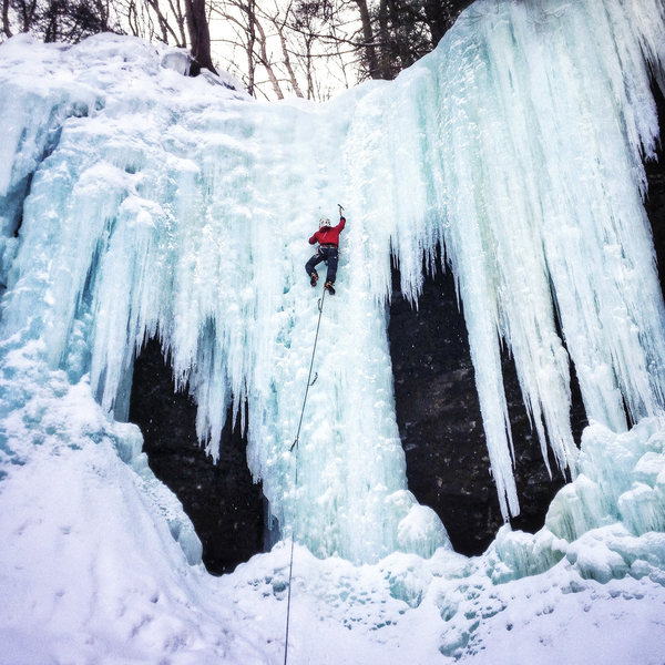
Photos [Hide ALL Photos]

Buttermilk, top pitch.
[Hide Photo] Buttermilk, top pitch.
Middle-aged Men on Motrin (the mixed portion before the free hanger).  Danny Pendimo.
[Hide Photo] Middle-aged Men on Motrin (the mixed portion before the free hanger). Danny Pendimo.
Buttermilk p3<br>
[Hide Photo] Buttermilk p3
Unknown climber, the right pillar last pitch of Buttermilk Falls.
[Hide Photo] Unknown climber, the right pillar last pitch of Buttermilk Falls.
Nice variation well away from the stream. Look way up and right from the "staging area" at the base of P1. Never any pick holes here!
[Hide Photo] Nice variation well away from the stream. Look way up and right from the "staging area" at the base of P1. Never any pick holes here!
Middle-aged Men on Motrin near the top of Buttermilk (M6, NEI 4+ ?).  Danny Pendimo on the moves on to the ice.
[Hide Photo] Middle-aged Men on Motrin near the top of Buttermilk (M6, NEI 4+ ?). Danny Pendimo on the moves on to the ice.
Upper falls (last pitch) of Buttermilk Falls.
[Hide Photo] Upper falls (last pitch) of Buttermilk Falls.
pitch 4
[Hide Photo] pitch 4
P1 of Buttermilk in the Catskills
[Hide Photo] P1 of Buttermilk in the Catskills
Chris with me belaying on the first pitch of Buttermilk
[Hide Photo] Chris with me belaying on the first pitch of Buttermilk
Chris Gomez leading the left side of the first pitch of Buttermilk
[Hide Photo] Chris Gomez leading the left side of the first pitch of Buttermilk
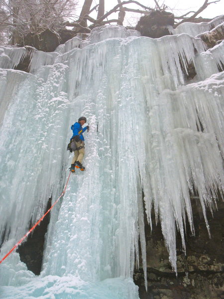
The top pitch.  This is the middle of what are usually three options (the right one is not in the pic)
[Hide Photo] The top pitch. This is the middle of what are usually three options (the right one is not in the pic)

Comments [Hide ALL Comments]

Dara
Peep's republic
 
[Hide Comment] This one is big fun; the approach can be a bit treacherous, especially if there is no snow, just wet leaves over slippery shale slabs. And take care not to punch through when crossing the creek. Jan 2, 2010
[Hide Comment] No need to rap P1, 2, 6, or 7. Look for tracks off to the side: climbers' right on P7, CL on the others. If you don't see fixed slings, it's because there's a walk-off. Lots of folks rap P7 and bust the ice underneath before it has a chance to fill in; please don't be that guy. Feb 8, 2010
[Hide Comment] Does any one know how how Buttermilk gets affected when there is a lot of snowfall? Avalanche danger? Feb 7, 2013
[Hide Comment] It is probably much easier to descend with a lot of snow especially with snowshoes. It can be treacherous with rocks and falling through ice with little snowpack. No avalanche hazard here. Feb 14, 2013
[Hide Comment] anyone know what township this is in ? Feb 27, 2013
The Morse-Bradys
Lander, WY
[Hide Comment] I'm not a local and found Kaaterskill Falls proper (which is not on this site but had numerous easy, and very steep routes) instead of Buttermilk falls but I am fairly certain that it falls on 23A somewhere between Haines Falls and Palenville there is quite a bit of ice on that stretch. With the given directions I'm still unsure, more cross referencing to other parking areas and other routes will be required before I understand, but there is plenty of see a climb and walk to it options on 23A so that anybody could get by for a number of days down there. Mar 6, 2013
[Hide Comment] Ryan - there's a full page map in the Catskill Ice guidebook that makes the location of Buttermilk and the other Rt 23A climbs very clear. Mar 15, 2013
TheIceManCometh
Albany, NY
 
[Hide Comment] Some approach beta...

The approach is fairly long. Dropping down to the steam from the parking lot bear left along the stream until you find a place to cross. Finding a place to cross can be difficult depending on how cold it has been. Definitely head downstream (left) .

Once across after you have trudged uphill to the logging road/trail head left again. Once you intercept the ravine head uphill. Don’t bother with the first small 20 ft ice you come across. Continue uphill for twenty minutes? Might have been 30 minutes. Seemed like a long time but that could have been partially because it is steep uphill. The first pitch to climb is apparent. It is 30 or 35 feet high. From there there are belay trees and rap anchors at the top of each pitch. Various route up each set of falls of varying difficulty 3/4. Feb 10, 2014
Jens Wachtel
New York, New York
WI3-4
[Hide Comment] great ice climb area.
As of today, all falls are in a perfect condition. Mar 16, 2014
Kurtz
Fort Collins, CO
 
[Hide Comment] Per my GPS, the approach is just over 3/4 mile. It took us 45 mins. Everyone seems to use a different variation of the trail except where it takes a right up the ravine. Pretty hard to go too far wrong.

To clarify the comment above. The logging road is old and faint, but is the obvious place to walk. It parallels the stream about 35 yds. uphill. Mar 17, 2015
Franz Buzawa
Brooklyn, NY
  WI3-4
[Hide Comment] Despite the efforts to clarify and provide beta for the approach (and descent) what's not emphasized is that there isn't an established trail down to the creek bed, or from the other side of the creek to the base of the route. So even if you follow the natural contours, which is easy to do in this case, you're bushwhacking or depending on following the tracks of previous parties. That said, my partner and I found a line of rocks, almost like the remnants of an old stone wall, that led down to a great spot to cross about 200 yds. down the road from the parking/pullout area on 23A (Kaaterskill Clove, across from Asbestos Wall). There wasn't any snow on the slope so it was easy to survey and pick a spot to head down. With lots of snow the choice might be more arbitrary. After you cross the creek head up slightly (maybe 50 yds. or so) then up and left, following the curve of the hillside, to the larger ravine. You should find the beginning of the route straight ahead as you turn onto the right flank of the ravine. It's a 30-45 min slog after you cross the creek, but well worth it. The route is fantastic, with many different variations depending on what tier and what shape the ice is in. I'd say plan for about 6-7 hrs car-to-car. Feb 24, 2019
Piotr Piotr
San Diego, CA
 
[Hide Comment] Linking up Wildcat is highly recommended! At the top of Buttermilk Falls just follow the LP trail for 15/20 minutes to a very obvious overlook. Rap from the top for the "money" pitch of Wildcat. Feb 16, 2021