
 Avg: 3 from 135
votes
Avg: 3 from 135
votes
Hike to Chasm Lake, walk about halfway around its north side (or just cross the lake when frozen), and ascend 400 feet of talus to the base of a very prominent gully on the south side of Mount Lady Washington. This gully leads to the saddle between the twin summits of the peak.
Climb the gully for 700-800 feet, and then scramble up 400 feet of talus to the top. Descend the east ridge of Lady Washington to the trail junction at the west end of Mills Moraine. It may be possible to return to the base of the route by descending a ramp which leads to the mouth of the gully. This ramp is quite evident as one approaches from Chasm Lake (it lies to the right of the route), and it appears as though it leads to open talus on the southeast shoulder of the mountain.
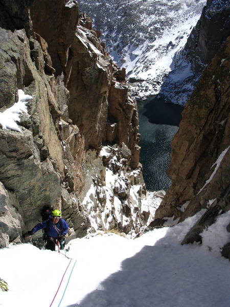
The route itself alternates between 40-50 degree snow chutes and tight, bottleneck constrictions in the gully. There are a total of five bottlenecks; the first, third and last are the most difficult (M2+, perhaps M3-). In the conditions we encountered, there were small ice flows at each of the constrictions, thick enough to accept short ice screws. The final exit out of the gully (the fifth bottleneck) provides a great finish to what we thought was a very worthwhile mountaineering route.
Bring a light rock rack with a few short and medium screws. One ice axe [could be] sufficient. Per Grant Hollis: bring ice tools.

 Continue with onX Maps
 Sign in with Facebook


The suggested rack is an educated guess. We were hoping to hike up Long's Peak the day we did it and had only crampons and one axe each (no rope or gear). When we bailed from Long's because of high winds, we decided to salvage the day by climbing as far up the gully (Martha) as felt comfortable and ended up making it to the top. It appeared to us that an alert leader could find adequate protection and belays and that the ice at the hard spots was thick enough for (short) ice screws.
Given that this year is one of the driest we've had in the last century, it's reasonable to suspect that the conditions we found are not the norm for this route. I'm guessing there's usually a lot more snow in the gully, so much more that the mixed bottlenecks may be entirely buried (which would be too bad -- the bottlenecks give the route its character). Go do the route in the next 6 weeks, and you'll likely find it in conditions similar to what's described above. It may provide good climbing (rather than just a long snow slog) in a normal year as well -- time will tell. Apr 25, 2002
I spoke with Topher Donahue about the FA, and he thinks the CMS may have guided this route on different occasions over the years (which is just as I suspected). It's curious that it's never been given a name, because it's a pretty cool route (we thought so anyway).
Bernard Gillett Apr 30, 2002
Bozeman, MT
I climbed a gully/ice route on the Southwest face of Mt. Lady Washington with Tom Jensen last Saturday. The Sunshine Gully - I'll call it for now contained 4 full pitches of WI3, M4 kinda fun stuff. Has anyone done this? Know of it, or beta on it? Approach by Chasm Lake, about 1/2 way around the lake on the normal trail. Bust up right on scree and into the gully. Top out by the summit and retreat by hiking down the east face of Mt. Lady Wash. Your input would be appreciated. BTW: look for some pic's of Alexander's, Smear, and Crazy Train, I'll post. All forming nicely, just about ready for you. Oct 19, 2004
Hi Greg - look up the route Martha listed on this site, and you'll have your answer. Cool route, isn't it? Oct 20, 2004
Louisville, CO
Top of route at 3pm- we let two guys from Neptune's pass us at mid-way. They simul climbed most of the route and probably finished an hour or so ahead of us. Trail head: 6pm
Finish- 300+ feet of scrambling to east ridge descent. Recommended gear- Nuts-small to mid, only small cams, pitons-4, screws-5, 6 slings and 2 screamers. No fixed gear that we saw.
Summary: Great route, great setting, good moderate climbing. Lots of loose rock, and you climb with your pack on the entire way so be prepared. Nov 5, 2004
The conditions are still excellent: good hard snow, a nice amount of ice, sheltered from the nasty wind.... I'm having a difficult time coming up with a more enjoyable alpine route in RMNP at this grade, and I think 3 stars is reasonable. It's a lot more interesting than Dream Weaver, for example (which I did again last July -- nice route, but not as good as Martha). Dec 29, 2004
Ciales, PR
By the time Martha is out of shape (end of April?), Dreamweaver is just starting to come into shape, and when they are both in "ideal" conditions, they are almost identical in difficulty except Dreamweaver is longer and higher with a better summit. I have climbed Dreamweaver when it is melted out, and it can be as hard as M3 staying right in the middle of the gully. Of course, ratings aren't what climbing is all about- it's all about the joy!
M5 is considered the equivalent to 5.9 in the rating system and calling this route even 5.6 is way off as it's not even comparable to 5.6s like the Bastille Crack and The Bulge (Eldo) or High Exposure (Gunks) or Osirus (5.7) at Lumpy Ridge. Check-out this page for more information on the mixed rating system: climbinglife.com/tech-tips/…
Both are beautiful, relatively easy alpine routes in one of the more classic settings in Colorado. Mar 22, 2006
Pinewood Springs
wikiloc.com/wikiloc/spatial… Dec 12, 2006
Broomfield, CO
Santa Fe, NM
Eli's latest report says that the route is in. Is the high avy danger at the bottom of the route or is it on the way to Chasm, where I am at in this photo heading back from Chasm View?
Delaware, OH
Ciales, PR
1. Coming up the Peacock Pool/Chasm drainage and staying on the south side below the falls and meadows if conditions permit. This wouldn't be a long detour but will require flotation to get around some deeper snow. Being in the valley bottom could be a terrain trap if these slopes release while you are under them, so this risk should be thoroughly assessed.
Or maybe better,
2. Without wind (good luck), hike to the Boulderfield and then up to the Camel descent and start down to Chasm Lake from just west of the summit of Mt. Lady Washington. From here, you could leave extra gear, do the Camel descent which is usually mostly large rocks and windswept enough to have minimal avalanche danger. The final couloir to the Mill's bivy spots could have some avi danger but below there, across Chasm, and up the route is typically LOW to MODERATE danger in the current, windswept conditions.
The route is likely in stellar conditions and these alternative approaches, in good weather, could make for a longer but more interesting alpine adventure. Let us know what you find?!
There is a decent photo of the Camel descent in the middle of this page: climbinglife.com/alpine-rou… Feb 13, 2008
Fort Collins, CO
Additional warning: be sure to check your descent direction off the top of Mt Lady Washington, as it is quite easy to descend the northeast face (instead of the southeast arete), adding at least an hour to your hike out. May 5, 2008
Denver, CO
I shot a video of the climb that you can see here: andyintherockies.com/trip/1… May 19, 2008
Cumming, GA
Fort Collins, CO
Fort Collins, Wyoming
Golden, CO
Missoula, MT
Colorado Springs, CO
With regard to ice conditions, I did it with very dull KTS Steel Kahtoola crampons and a single CAMP Nanotech Corsa axe. There was some ice but not much and always a good stem onto rock or snow if needed to get around it. But, I think conditions are probably changing up there daily at this point. Apr 4, 2013
Denver, CO
mymountainramblings.blogspo… Nov 16, 2015
Boulder
West Lebanon, NH
No ice to speak of. The rock is nicely frozen together though. Fun final two pitches. The approach/descent was heinous with the low snow coverage in the boulderfields. Nov 1, 2018
Boulder, Co
Also if someone finds my Honda key on the East Ridge walk off, let me know. Apr 4, 2021