
 Continue with onX Maps


ID 107227626 ·
·
Copyright Violation?


Rate Photo

B Roth
Jul 28, 2011
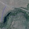
“satellite photo showing the path of the trail from the road to the cliff line. The largest shaded area on the bottom on the right side of the trail is the unemployment wall.”


0 Comments