
 Continue with onX Maps


ID 107217291 ·
·
Copyright Violation?


Rate Photo

Billcoe
Jul 18, 2011
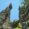
“Overview map. Google will show the 4620 road. Alternatively, click on http://mapper.acme.com/ if you copy and paste N 45.07790 W 122.09900 in the empty box in the lower right hand corner and click "find", it will get you this. The "3605" noted is the elevation of the formation. In the upper right hand corner you can click on topo or satellite view. This is an amazingly handy site you might book mark and there is no charge for it.
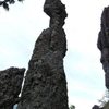
This hand drawing zooms in to some finer details which you can match up to the topo map at Acme mapper.
When you look at the drawing, you will see that the parking is at a junction, or a T- of a road. That is a little dirt road, it has an ugly greenish gate there (which is open, but behind the gate they dug a big berm so you can't drive it, it's less than a 1/4 mile down the now closed dirt road to a flat slash pile (old burned out logs form a logging operation) with a view of the rock formation. The trail heads into the woods as noted on the map, close to the same direction of the rock, ducks off to the left of the ridge and drops to the base with a few obvious switchbacks.
A couple of good links to check a few days before:
http://forecast.weather.gov/MapClick.php?lat=45.11230010229608&lon=-122.21026618033648&site=pqr&smap=1&unit=0&lg=en&FcstType=text
I had good sucesss looking at the tombstone hwy 20 road cam to see approx what the actual conditions would. Here: http://www.tripcheck.com/Pages/RCMap.asp?curRegion=4&mainNav=RoadConditions”


1 Comment