
 Continue with onX Maps
 Continue with Facebook


Utah Areas restructure


|
|
I am so lost looking through areas of Utah trying to find a climb or trying to figure out where to place routes not yet posted. It's been going on for years and I've gotten by fine because I grew up here and know a lot of the state. However, traveling to other states and countries there are obviously better ways to organize things than to just drop a 'fresh' climbing area straight into the Utah bracket. I have found and corrected at least 3 duplicate areas holding many of the same routes in different 'locations' over the last year or two. I'm sure many of you share my frustrations, and I can't imagine planning a trip here from out of state and just trying to find a place to climb without knowing any of the local names. So over the next week or so I've decided to put my slightly OCD and currently unemployed brain to use and completely overhaul the organization of the entire state. Oh Boy. I could use some input from those of you who also climb here, in an effort to make this as easy as possible for everyone to understand and to upload new areas to the appropriate place. My vague plan is a entirely new top level structure with 6 to 10 sections of the state that anyone with a highway map can figure out: Northern Utah (Logan to Nephi) *Mostly occupied by the existing Wasatch Range Area Northeast (Uintas and Vernal, mostly) Central Utah (Nephi to Hanksville to I70/I15 Jnctn) Southwest (70/15 jnctn to St. George and also East to Grand Staircase) Southeast (Moab to Powell) West Desert (Everthing West of Great Salt Lake down to Milford-ish - This one is mostly already set up!) I would love some feedback on these ideas and a place to discuss specific crags and cities and where they belong. While I've started making a few of these top level areas, this is not set in stone and I'm happy to separate them further if people think we should have a few more. I also could REALLY use some help coming up with descriptions for these areas, so please go to the pages and hit that suggestions button! - David |

|
This has been on my radar for a long time. I'd be happy to work with you on this. The other big piece is to split up the Wasatch range into more manageable regions. I'd been thinking Southern Wasatch, Salt Lake Area, Salt Lake to Ogden, Northern Wasatch, and Wasatch Back. |

|
D C wrote: Kinda brainstorming of the top of my head and I came up with a similar breakout. An overview map could show the areas...NW, NE, Central, SW and SE. Yeah, right now, pretty long list of areas. I use the 'proj for a lot of trip planning...usually pull up the map first to see what's near where I'll be. But, also use the "best climbs for YOU!" search to see where the highest gob of routes are at the grades or type of routes I prefer. Good on ya for taking it on. |
|
|
Andrew Gram wrote: Ahh I would love for that to happen too! I've always thought "Wasatch Range" was a little too all-encompassing with almost half of the state's routes. |
|
|
Brian in SLC wrote: The biggest pain to me is I see things on the map, go to find it later or add something new and literally cannot find it through the menu. Like why Hanksville, which could be a hub for that entire section, is buried 4 layers deep but some place called Nuwuvi Ledge is a top level area makes no sense. |
|
|
I think if you split Northern Utah and Central Utah at roughly I15 to create a single new West Desert region that looks pretty good. |
|
|
So I did something similar for the South Island area of New Zealand, and learning from that my idea was to split everything (as much as feasible) into similar climbing styles and/or regions and by actual physical barriers. Freeways, rivers, mountain ranges all make great dividers that people can see in person. This eliminates confusion on what area new climbs should be placed into. The following map was quickly put together and will need some refining but it's a colorful representation of what's been rolling around in my head lately: 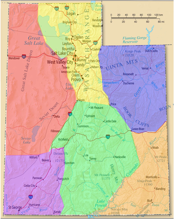 The main things I like about this estimate is the consolidated West Desert (red) and smaller SE (orange) and SW (purple) where there are high concentrations of a similar style. Improvements I could see are splitting the populated areas of the Wasatch potentially? Thoughts? |
|
|
That looks pretty much perfect to me, though i'd put the Salt Lake in the West Desert since Antelope and Stansbury Islands belong with the Oquirrh and Stansbury Ranges. I went ahead and reorged the Wasatch. I moved Echo Canyon from a top level Utah area to a Wasatch Back area, which I think makes sense based on approach and who climbs there even if the geological boundary is fuzzy. I moved Antelope Island to the West Desert. Let me know if it makes sense, if I made mistakes, send me hate mail, and especially if climbers passionate about those areas would like to take over the area descriptions from the minimal placeholders I added. |
|
|
Andrew Gram wrote: I'll redraw the Lake area, I like that idea. Once we get bit further I'll drop some of these maps in all the areas. A Wasatch Back area sounds perfect, and yeah Echo should go there with PC for sure. For now I'll keep plugging away at the smaller areas and fixing things up! If anyone else out there want's to fill in descriptions we could use some help with the new major areas for Utah! |
|
|
I've started moving some stuff around. It feels like it may make some sense to split South Central into a Central and a South Central. Central would have Maple and Maple-like areas, Joes, Huntington, Price Canyon, Triassic, Richfield choss, etc. South Central would be more deserty like the Swell, GSNM, Henries, etc. |
|
|
Andrew Gram wrote: I had been thinking about something like that... I can see splitting maybe Spanish Fork canyon away from the populous cities, but the border between Central and S Central could get interesting with the Swell not really conforming to easy lines but maybe I'll toy with that too. Edit: Three post per day limit.. woops. 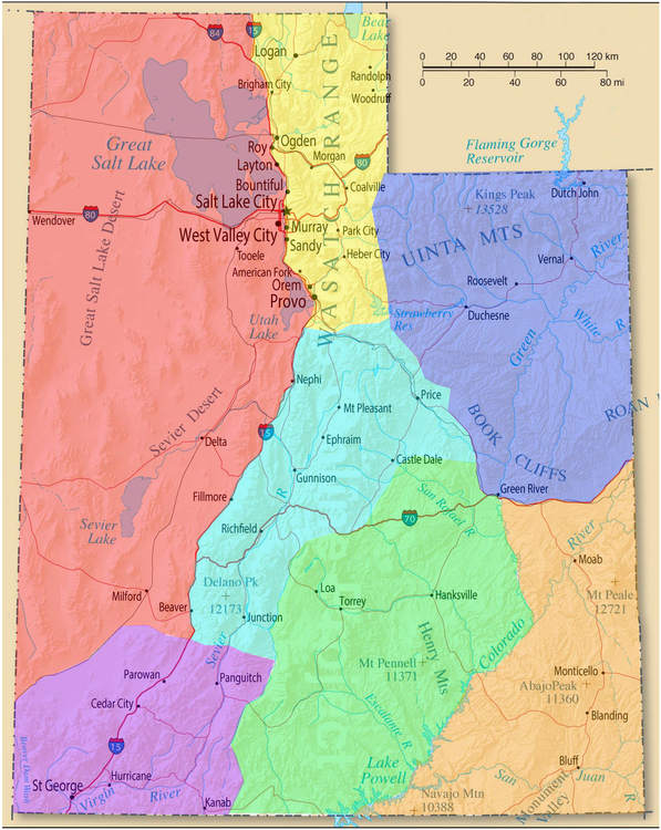 Thoughts on Central borders? Any other areas that need adjusted? |
|
|
Dope. Thanks guys! |
|
|
Amazing! Thanks for doing that! I'll start going more thoroughly through some of the bigger sub-areas soon and note anything out of place. Also working descriptions a bit more the next few days. It's looking really good guys great work! What are people's thoughts on like Spanish Fork Canyon that's currently under a Wasatch subset? Price canyon seems to be Central to me but Sp Fork could go either way? |
|
|
Spanish Fork to Soldier Summit should be Wasatch I think. Would be awkward to carve it out with nebo and santaquin south of it. |
|
|
Just a heads up that based on the current map graphic, Joe's, Huntington, Axe Handle, Wales, and Monroe should all be in central Utah and not south-central. Thanks for the hard work! |
|
|
Thanks y’all!
Mill Creek is arguably in the LaSal Mtns. High Valley has zero useful information and should probably be deleted. |
|
|
Rob and John, thank you both, this is exactly the kind of info I'm looking for to help improve all these weird areas! Keep it up and if you notice anything out of place you can hit that 'improve page' button on the area to send it to the admins quickly. We'll get working on anything posted here as well as soon as possible! |
|
|
Thanks for the suggestions! I moved the areas from South Central to Central. I removed Moab as an area altogether for now and used its old page for the Southeast Area. I'm mulling over adding some sub areas - maybe Moab to the Bookcliffs and South of Moab. Thought? I keep hoping someone will add info for High Valley. Those pictures are cool and I hate to totally orphan them. I'll move Mill Creek to the Lasals. |
|
|
While your in restructuring mode I would like to make a few suggestions for Cache Valley/ Logan area. As it stands now it's hard to discern what climbs are where. I would suggest changing the area name to Cache Valley vs. Logan as that itself is deceiving. With most climbs being in some type of canyon having the canyon names listed with the different rocks/ crags listed under the canyons they are in. If you are unfamiliar with some of the areas I am willing to help. |
|
|
Here are some unsolicited thoughts: I was just looking into a swing through Utah on a road trip and noticed that the organization was a mess. So I'm glad the admins are taking action! I think the recent California reorganization is a good model to work from -the admins got rid of confusing designations like "Central Sierra" and "Northern Sierra," which weren't in common use outside of that page and which had weird overlaps (ie the old northern sierra section didn't include Lake Tahoe), and replaced them with top-level sections for the major destinations (Yosemite, Joshua Tree) and then sorted the more minor areas into either geographical sections with evocative and commonly-used names (Lake Tahoe, Redwood Coast) or areas that are defined by the roads that access them (Sonora Pass (highway 108), Sierra Eastside [everything on the East Side is accessed by 395, even though geologically it's the same hunk of rock as the rest of the Sierra]). So my suggestion for Utah would probably give top-level status to major destinations like Zion, the Creek, Joe's, Little Cottonwood, and a few others, and then have geographical sections for the rest of the "minor" crags (and California gives this status to some pretty well known spots, including Lovers Leap [shoved into the Tahoe section] and ORG [in the East Side]). You probably don't want people spending a week in the Creek to have to go an extra level down to find their crag; they're in the Creek and they're probably not going anywhere else. Same with Yosemite - people don't need to know they're in the "central sierra" or whatever. My other suggestion is to tie the names of the top-level regions to actual geographical markers rather than calling them "South-Central Utah" or whatever. It makes it much easier to intuit where to find the particular location you're looking for. So I would call the Southeast area ( the yellow area in DCrane's map) something like "Moab, Indian Creek, and Southeast Utah" or "Four Corners" or "The area with the cracks and the towers". And I would really resist calling the blue and green areas "Central" or "South Central." These will be very difficult for out-of-staters to interpret without resorting to a different map. I would suggest something like "I-15 - Nephi to Junction" or "Colorado River Valley" if they work. By contrast, a state org plan I don't like is Idaho, which is broken into 5 quadrants (N,W,Central,E,S) with no further detail in the names. There's an overview map on the website, which is helpful, but it doesn't show up as you're navigating through the app. I'd rather see more clues in the names of the sections. For instance, if you're not from the area, guess which of those areas contains City of Rocks or Elephants Perch without looking at a map. |
|
|
I'm hesitant to surface areas directly under Utah. That is really what the featured areas designation is for, and I would expect to see Indian Creek alongside the rest of the Southeast Utah crags. I'm going to request a new feature to make the featured areas prominent on the state page as well as in the overall directory. The evocative names suggestion is a good one, but tricky for Utah. We already do that with West Desert, and based on this feedback I switched North to Wasatch(map update alert DCrane!). The other areas are harder. Its pretty common to hear Southwest Utah called just that in say TV weather reports, and the only other nickname for that area is racially problematic. Maybe Zions, St George, and Southwest Utah but that doesn't really feel like an improvement to me. It is also very common to refer to Southeast Utah. Four Corners would be misleading since that is generally the Navajo lands in San Juan county. Moab, Indian Creek, and Southeast Utah could work, but it feels more awkward than simply Southeast Utah to me. Northeast would be tricky to name - it is one well known area(Uintahs) and some other areas that have nothing in common other than being in a big empty quadrant of the state. Maybe it should be called the Uintahs and Northeast Utah. Central Utah again has no unifying characteristic other than being south of the Wasatch, not the desert, and in the center part of the state. I think if Joe's and Maple were more visible on the Utah area page calling this area Central would be fine. South Central is awkward for sure. Its a tricky one to name - mostly desert, but then you have oddball high quality crags like the Henry's and the Jungle. Capitol Reef and Grand Staircase are better known to non-locals, but the San Rafael Swell is where most of the climbing is. I'd love to hear name suggestions and other opinions. Now that we are finally doing this, we really want to get this right! |


