Continue with onX Maps
 Continue with Facebook


Gannett Peak/Wind River Range


|
This Google Earth topo Overlay is pretty nice for route planning. |
|
|
|

|
Warbonnet wrote: As anyone knows who have spent decades in this range in all seasons, winter never leaves, even in the dead of summer.For example, Lonesome Lake August 9, 1974: 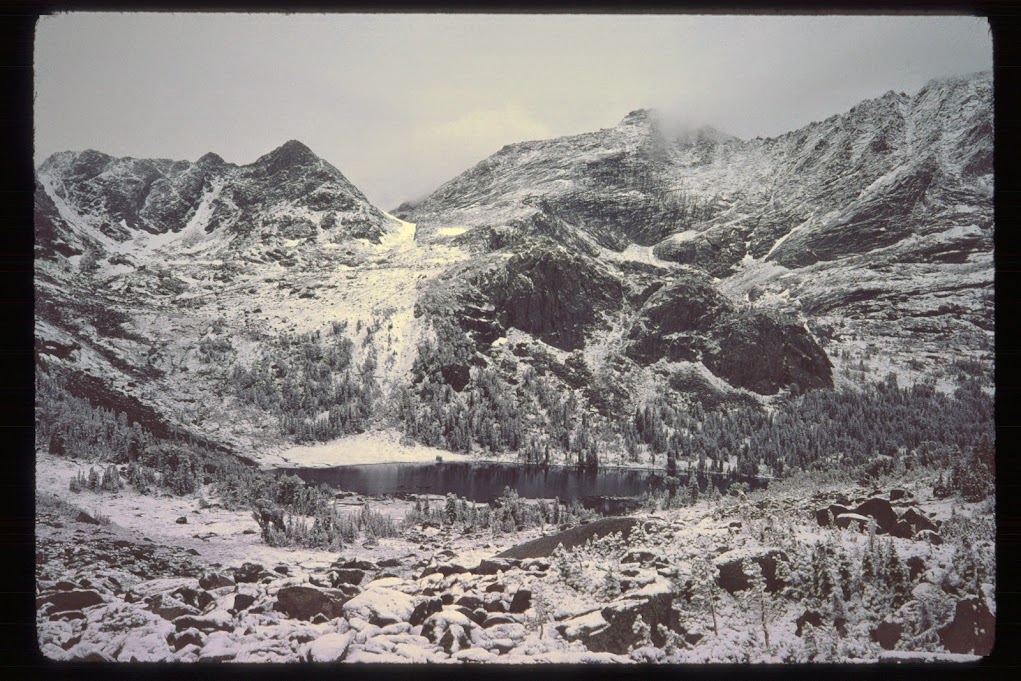 |
|
|
Warbonnet, you are the man, thank you for you wisdom for winter gannett, some friends and i were gonna go try it and your words have definitely helped out. never would have thought to need wands and i figured crevasses were a non issue. thank you thank youy |
|
|
Brian in SLC wrote: I've found I prefer black to mark my wands. A bit anal, but, I use black/yellow caution tape as well as a long length of black garbage bag. In the white room, easier to see black I think especially if its fluttering in the breeze. I have a hard time picking up orange in a white out. YMMV. Cheers!Brian, very interested to see how you make yours. Will post mine...your "fluttering" prompted an idea... |
|
|
rgold wrote: For example, Lonesome Lake August 9, 1974:rgold's photo is priceless, perfect timing, excellent and a beautiful photo. For anyone who has been to Lonesome Lake and looks climber's right of this photo knows what this means, esp. in AUGUST. Yikes, depending. The "real" Warbonnet just to right of the pic (but can't see it). Cirque of the Towers. |
|
|
I'd go in from the east, Trail Lake. We've done it several times, winter and spring...less avalanche trouble (not none, just less), good camping right up to the glaciers -- such as they are these days -- and overall easier route finding. A good trip. If you have the time to deal with the logistics, go out to Pinedale. |
|
|
Alex Palombitch wrote:Warbonnet, you are the man, thank you for you wisdom for winter gannett, some friends and i were gonna go try it and your words have definitely helped out. never would have thought to need wands and i figured crevasses were a non issue. thank you thank youyAlex, thanks, but no wisdom. Just learned the hard way in the Winds. Several are going to post on wand-construction. I...and others in post....suggest you do not buy wands (won't find what you want); best to make them yourself -- will be glad you did & then many uses afterwards. Crevasses, -- some but one is one too many -- not the main hazard though. Moulins, snow cliffs in winter, white-outs, ground blizzards. Good luck Alex!! Is a great trip. |
|
|
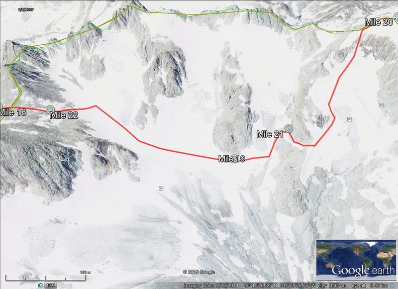
The Google Earth photos are just for me to get a look at the area as I know it's not an exact of what the range looks like right now but it does help, I have actual topo maps and a guide book for the range as well. |
|
|
As you can see the red line are gpx tracks for a gps, Though I know you can't just rely on tracks, they can help in many situations, of course taking along a Compass and maps help as well. I've not started on creating the wands yet. |
|
|
Gitrinec wrote:As you can see the red line are gpx tracks for a gps, Though I know you can't just rely on tracks, they can help in many situations, of course taking along a Compass and maps help as well. I've not started on creating the wands yet. Gitrinec wrote:The Google Earth photos are just for me to get a look at the area as I know it's not an exact of what the range looks like right now but it does help, I have actual topo maps and a guide book for the range as well.Got it, great. This kind of "in the trenches" stuff pays back in spades, whether it goes into the final "route gestalt" or not; famous quotes at bottom of this post proves it. I believe route planning is a lot like business plans: huge effort (training), min/max revenue calculations (elevation gain/loss calculations per foot per step, no deviation), risk analysis 100 times (read all annual issues of "Accidents in North American Mountaineering" starting with first pub in 1948). A month into biz plan, nothing on schedule, 1/16th up planned route, not going well, then do what all summiters do: toss the plan long before it goes wrong and rely on what you learned when planning...its the planning process that's important, because no matter what, chances are that the successful RT route is not what you had exactly planned. Legendary explorer, mid-1800's Jim Bridger (as in Bridger Wilderness) when asked if he had ever been lost replied: "NOPE, never been lost. There were times where I didn't know where I was, but never was lost". |
|
|
Ya, us Marines aren't big on surrender, I'm thankful for the Land Navigation training we had, that'll help a lot, us grunts had to know how to use a map and compass, it didn't matter what rank or MOS you had. Well it was either Maj Gen Oliver P. Smith or Lt Gen Chesty Puller During the Korean war. I've found even reading some mountaineering books helpful as well, lots of good info, Ed Viesturs, No shortcut to the top, and Freedom Climbers the golden age of Polish Climbing, some of those Polish Climbers did all the 8,000 meter peaks during the winter, crazy. |
|
|
Andrew Carson wrote:I'd go in from the east, Trail Lake. We've done it several times, winter and spring...less avalanche trouble (not none, just less), good camping right up to the glaciers -- such as they are these days -- and overall easier route finding. A good trip. If you have the time to deal with the logistics, go out to Pinedale.Andrew, you finally convinced me via other posts that this can be done. Still not easy but you have a lot of Winds experience. Thought I knew that summer trail enough to avoid a winter trip, but was wrong. You remind me of Joshua Slocum, first man to sail single-handedly around the world (late 1800's). 46,000 miles. Upon return, wrote a curiously titled book: "Sailing Alone Around the World". Hero sailor, frustratingly understated w/little detail (not a reference to you...but sort of, to your credit!!) Writing about rounding the Cape of Good Hope (S. tip of Africa; ranks as one of the roughest seas in the world): "And so I sailed around the Cape of Good Hope, and then up the Coast of Africa". So, "...go out to Pinedale." Seriously, well done. |
|
|
Gitrinec, here you go. |
|
|
Andrew Carson wrote:"...... the glaciers -- such as they are these daysz'.Re: the glaciers, you and I are roughly the same age. Assuming you've lived in Wilson for a long time (as most do), and your comment, you too must have seen them back in the day? Am somewhat involved with geo-heads and glaciologists working on the Dinwoody; it is doing some very odd things...I'll post on that because it's relevant to this forum. I also shouldn't be so glib re: your suggested route; I was actually poking fun at myself for having done the hell trip (but the most amazing) on the NF of Gannett. Have been around that range for a long time but many have been there longer than I have, that's for sure. The Bonney's and Finis Mitchell being the notables. |
|
|
Warbonnet, just curious did you re-post an image if so I don't see it, thanks again for the info. |
|
|
 Of the standard routes I've done summer, winter, blue lines show this (but doesn't show all, just ones relevant to the OP, (you)...who also posted this Google Earth pic upon which I provided my own beta, but post yours... Gitrinec, You have professional navigation experience, besides you saying so, it's obvious you do. Used three diff yellow dots for different reasons: small dot is single wand, larger circle w/yellow dot is double wanded, larger yellow dot with larger yellow center is triple wanded, meaning that's the "apex" of the hazard zone, so on return, for example, say camped at Bonney or Titcomb that point should be passed climbers left on approach, on return, pass to climber's right (I did screw up placing the apex hazard at your Mile 19...should show wanded to pass climber's right, not the left; exact location doesn't matter, it's the relative point to the 3 wands.) I have my own way w/beta mapping winter routes when wands used; others have theirs. All methods useful. I'll fix the apex danger wand misplacement and re-post, esp. since it's a beta map. Will post other beta photos showing moulins, small crevasses and "don't go here" zones. The largest yellow dot on the map, on the ridge below your Mile 20 with largest center (just north of "The Skulls") is the most critical part; in white-out, this would be really dicey, but if anyone is up that far, then I'd expect they would know what they are doing, as opposed to me. In other words, such conditions would require skilled travel, rope management, proper equip, etc. Worst case, this point, if seemingly impassable could be a serious undertaking, high wind storm if caught there, so that point should be appropriately wanded, by choice of method. The Skulls has high winter death trap warnings (from me); looks like easiest walk off of summit all seasons in case of people bailing or think it's an easy way off). Even if could bail, hot frying pan into another: down steep, long Glacier Pass & on to large, very remote, seldom traveled even in summer, Mammoth Glacier. Very difficult to get out in winter. This area in general (but more north) is the approach to the hellish NF of Gannett. Gitrinec, your GE photo was a perfect, valuable, contribution, so thanks. Traveling this area is just not optional (for fun or emergency); about 16 or 17 years ago a major cliff collapsed and blew chowder down maybe 2,500 ft, now a horror show and even now in summer, standing in Glacier Pass, can smell the dust like it just happened. No easy way up or down Glacier Pass; just avoid it all seasons, and it's not really a "pass". |
|
|
It's hard to get enough of the Winds at any time of year. |
|
|
These might help someone get an idea of the area a little more. |
|
|
Depending on weather conditions, etc.. I'm going to try to take pictures mark some spots with the GPS when I'm there but only if that area allows it, lol I really don't think being there for longer than I have to is overly smart... |