Continue with onX Maps
 Continue with Facebook


The 2013-2014 Colorado Ice Conditions Thread


|
Sorry I don't have a photo, and I couldn't see the very bottom, but a hard man or woman might want to take a look at The Squid in RMNP...It looked pretty good to me today. |
|
|
Does anybody know what condition bird brain is in these days? |

|
Lincoln Falls is plenty snowy. Most of the climbs seem to be in. Sickle on a Stick has a huge horizontal fracture and it looks to me like it's just waiting to fall over. Kind of alpiney up there today. |
|
|
Anyone checked out the park since the last big snow? Longs Cirque? All mixed up? |
|
|
 A nice blog about some Fort Collins Ice. nococlimbing.org/news/zero-… Enjoy! -NCCC |
|
|
Will a 70m rope get you off the Designator? I've used dbs in the past. Just wondering if a 70 will do the job, or end up just a bit short. |
|
|
Yes, a 70 will get you off RD with rope to spare |
|
|
has anyone gotten on Martha lately? |
|
|
Anyone been on Hidden Falls in Glenwood Canyon recently? Tracks in place? Ice conditions? Thks! |
|
|
Can I please hear some RMNP conditions? Ice, snow, share some gravy! I'm headed that way next week. |
|
|
Andy Hansen wrote:Lincoln Falls is plenty snowy.Kind of alpiney up there today.The Lincoln Falls area has consistently been at a level 3-4 on the CAIC avalanche danger forecast for the past month. It's terrifying that people have been climbing up there recently. Just look at the avalanche fatalities and accidents that have occurred in the last few weeks. avalanche.state.co.us/accid… |
|
|
jaws was in, but mushy last weekend. maybe this cold will help |
|
|
Taylor-B. wrote: The Lincoln Falls area has consistently been at a level 3-4 on the CAIC avalanche danger forecast for the past month. It's terrifying that people have been climbing up there recently. Just look at the avalanche fatalities and accidents that have occurred in the last few weeks. avalanche.state.co.us/accid…So the entire Front Range and Sawatch Range should be avoided? Please spread the word some more. |
|
|
^^ avoid hot doggie etc. |
|
|
GLD wrote: So the entire Front Range and Sawatch Range should be avoided? Please spread the word some more.There has been a lot of talk here in the Vail/Summit Zone among avalanche professionals and recreational users that the CAIC forecast has been inconsistent and unreliable this season. For example, early in the season the CAIC rated the avi danger at a level 2 when it was actually a very realistic level 3 and this gave the public a false sense of risk assessment and Ten Mile Canyon was crawling with climbers in every drainage that week. The other blatant example was the "first big" avalanche cycle in January that the CAIC deemed a level 3 danger, while the rest of the western US (UT,WA,OR,ID,MT) was at a level 4, and when the skies cleared in Summit after the storm there were multiple natural avalanches on EVERY peak that you could see from the valley. The statistics of recent accidents don't lie. The CAIC defends their forecasts as not wanting to "cry wolf" to the public; avalanche science is a science and should be mostly influenced objectively with very little subjective opinion involved. Sorry for the rant, this has been on my mind since December. I hope that we can bury these persistent avalanche issues and enjoy some steep terrain in the near future;) |
|
|
Taylor-B. wrote: There has been a lot of talk here in the Vail/Summit Zone among avalanche professionals and recreational users that the CAIC forecast has been inconsistent and unreliable this season. For example, early in the season the CAIC rated the avi danger at a level 2 when it was actually a very realistic level 3 and this gave the public a false sense of risk assessment and Ten Mile Canyon was crawling with climbers in every drainage that week. The other blatant example was the "first big" avalanche cycle in January that the CAIC deemed a level 3 danger, while the rest of the western US (UT,WA,OR,ID,MT) was at a level 4, and when the skies cleared in Summit after the storm there were multiple natural avalanches on EVERY peak that you could see from the valley. The statistics of recent accidents don't lie. The CAIC defends their forecasts as not wanting to "cry wolf" to the public; avalanche science is a science and should be mostly influenced objectively with very little subjective opinion involved. Sorry for the rant, this has been on my mind since December. I hope that we can bury these persistent avalanche issues and enjoy some steep terrain in the near future;)I don't necessarily disagree with you about your conclusions but more your method.(though interested to hear more about it offline). Because the rest of the US is at a level doesn't mean we should be (though we should think about why we are different), and because you saw a bunch of slides doesn't mean their assessment was wrong. Obviously, the most important thing is for a backcountry traveler to be aware and alert. Officer's Gulch is known avy territory, huge fields above the climbs-and unfortunately, I've never climbed there. I'll raise a glass to burying those persistent deep avy's. |
|
|
Couldn't edit my last post. A few incidents are statistics but don't prove anything, the forecasts have for all recent memory had discussions about the persistent slab and deep persistent slab and the huge consequences that would be associated with them. PErhaps the new forecast layout is not emphasizing this enough for some people. |
|
|
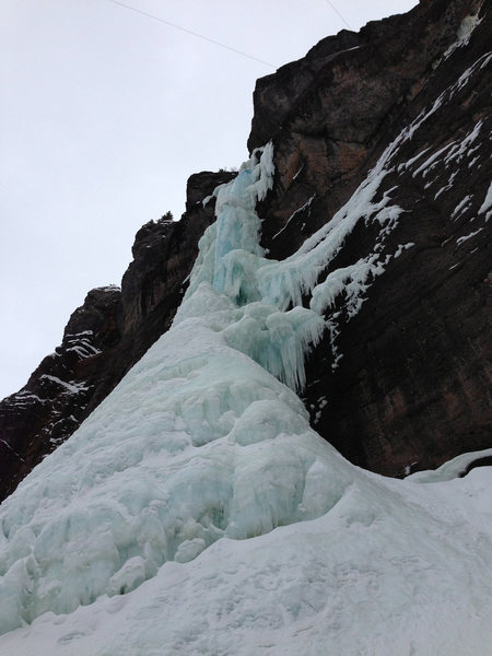
If you have ever wanted to do Ames, now is the time. The whole climb (Including the first pitch) is in great shape. |
|
|
Taylor-B. wrote: There has been a lot of talk here in the Vail/Summit Zone among avalanche professionals and recreational users that the CAIC forecast has been inconsistent and unreliable this season. For example, early in the season the CAIC rated the avi danger at a level 2 when it was actually a very realistic level 3 and this gave the public a false sense of risk assessment and Ten Mile Canyon was crawling with climbers in every drainage that week. The other blatant example was the "first big" avalanche cycle in January that the CAIC deemed a level 3 danger, while the rest of the western US (UT,WA,OR,ID,MT) was at a level 4, and when the skies cleared in Summit after the storm there were multiple natural avalanches on EVERY peak that you could see from the valley. The statistics of recent accidents don't lie. The CAIC defends their forecasts as not wanting to "cry wolf" to the public; avalanche science is a science and should be mostly influenced objectively with very little subjective opinion involved. Sorry for the rant, this has been on my mind since December. I hope that we can bury these persistent avalanche issues and enjoy some steep terrain in the near future;)Spatial variability is the name of the game in with the CO snowpack. It's impossible to make CAIC forecasts apply to every slope angle,aspect and elevation in each the enormous zones they forecast for. Orographics alone causes snowfall amounts to vary widely over small distances (e.g. Abasin vs. Keystone) so all they can do is outline general problems and release general advisories. As an n=1 observation, I was out in RMNP on a level 4 day with an advisory issued, saw zero signs of instability and safely skied 38 degree slopes all day. |
|
|
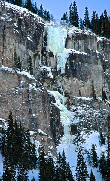
Got recent photos of Bridal Veil, Ames, The Talisman and more on the site. |