Continue with onX Maps
 Continue with Facebook


New Feature: Topo Photos

|
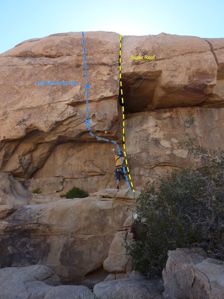
We're excited to announce a new feature we're calling "Topo Photos". You can now draw route lines, bolts, belay spots, etc on any photo in Mountain Project, directly on the web site. |
|
|
Wow, really cool news. Thanks a lot Alma, that is a really helpful feature. Cheers. |

|
Fantastic work Nick and Alma! Just used it on a photo of mine and found it incredibly easy to figure out and use. The "Show Topo Overlay" toggle box is a really nice feature too. |
|
|
Just tried it on one of my photos. Really cool! I'm sure this will help on many photos. |
|
|
Awesome! Just what I've been waiting for. |
|
|
I usually do my topos in Illustrator, but this is really great. I hope this motivates more people to contribute to this site. Thanks to everyone who made this possible! |
|
|
Ryan Nevius wrote:I usually do my topos in Indesign, but this is really great. I hope this motivates more people to contribute to this site. Thanks to everyone who made this possible!I've heard of others using illustrator (esp for boulder field maps)... have you used both? or is indesign just a refined slimmed down illustrator. |
|
|
J.T.R. wrote:Is there any way to zoom in on a photo to make accurate bolt (X) placements? I also checked out the topo that Jason Halladay did and when I clicked on the photo to make it larger the topo lines disappeared. This is a great addition to MP and hopefully it continues to improve with a feedback and working out any bugs. Thanks Nick and Alma!!2nd this. cool feature! Zooming in on the photo losing the topo info is a problem though. I haven't tried printing the photo in a mini-guide yet, hoping that works though! |
|
|
Looks amazing!!!! Well done indeed. It would be further amazing if this editor could be loaded on the app. The ability to take photo and add route beta seemlesy would be a game changer. Cheers |
|
|
Just updated (with help from Alma) so that you now edit the high-res version of the image. Two advantages: |
|
|
Morgan Patterson wrote: I've heard of others using illustrator (esp for boulder field maps)... have you used both? or is indesign just a refined slimmed down illustrator.I actually mis-typed last time...I meant to write "Illustrator" for topo creation. I use Photoshop, Illustrator, and InDesign. My workflow is usually: edit original photo in Photoshop (levels, crop, etc), import into Illustrator, draw topo in Illustrator. Photoshop is best for photo manipulation. Illustrator is best for creating shaped visual elements such as topos; it is vector based (vectors can be easily manipulated, altered and resized without a loss in quality). InDesign is best for creating layouts or print-ready files (e.g. a guidebook). While InDesign also includes some of the features that are included in Illustrator, creating high quality vector graphics is not its main focus. I hope this makes sense. In a nutshell: Photoshop for image editing, Illustrator for vector graphic creation, InDesign for layouts. |
|
|
This is a fantastic feature that will hopefully lead to many better topo photos. I think it could possibly be improved by providing a standardization for different types and grades of routes. |