The Nest Rock Climbing
| Elevation: | 7,276 ft | 2,218 m |
| GPS: |
39.73926, -105.41377 Google Map · Climbing Area Map |
|
| Page Views: | 2,134 total · 61/month | |
| Shared By: | Tal M on Jan 20, 2022 | |
| Admins: | Leo Paik, John McNamee, Frances Fierst, Monty, Monomaniac, Tyler KC |
 Access Issue: Seasonal Raptor Closures
Details
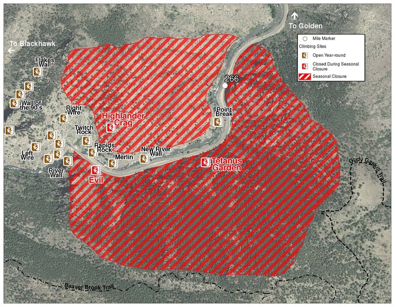
Raptor Closures Effective February 1-July 31
Visit: jeffco.us/open-space/news/2…
Tunnel 1 closure
For more details visit: jeffco.us/open-space/alerts…
The two areas Jefferson County Open Space intends to close in Clear Creek Canyon, shown on the attached maps, encompass the active eagle nests. If the Clear Creek eagles continue to nest in the active nests, these areas will remain closed from February 1 through July 31. If the eagles choose different nesting sites, the closures will be adjusted accordingly to protect those eagles during their breeding season.
Currently, rock climbing areas that fall inside of the seasonal raptor closures include:
Blonde Formation
Bumbling Stock
Evil Area
Ghost Crag
Highlander
Skinny Legs
Stumbling Block
Tetanus Garden
Fault Caves
Description

A sister crag to Convenience Cliff, The Nest is similarly situated and follows the same guidelines of being west facing and above the road (tread carefully!). The Nest is mostly moderates with potential for some harder lines interspersed. The rock is generally high quality, though featured, and with clear creek rock we all know features are just a matter of time in the end.
Do your best to tread lightly as you would at convenience, as fallen rocks always have the potential to meet the road below. The routes have easy walk-up TR access.
L->R:
A. Babushka, 11-, 1p, 90', bolts.
B1. Learning To Fly, 10-, 1p, 50', bolts.
B2. Even Birds Need Insurance, 9+ PG-13, 1p, 45', bolts +/- gear.
C. Jack's Yellow Jacket, 9, 1p, 45', gear.
D. Flight of the Sparrow, 9 PG-13, 1p, 45', gear.
Getting There

Convenience Cliff approach: "park on the right, West of Tunnel Six. Cross the road, and walk West on the road, past the steep hillsides on the left, until you reach a yellow "curve ahead" cautionary road sign (across the road) where you can head into the forest above. When you reach the old road bed, head back East on it, above the steep hillsides, to its end. Contour East, hop across a boulder, and follow cairns East and uphill to the crag. ~15 minutes. Convenient, eh?"
Once you reach Convenience Cliff, go around to the break on the left side of the cliff. Directly in front of you, 100 yards, you'll see a very obvious crag. This is The Nest. It is dealer's choice from here to get to the crag, though there are some fairly obvious trails a few feet uphill.
Weather Averages
|
High
|
Low
|
|
Precip
|
Days w Precip
|
| J | F | M | A | M | J | J | A | S | O | N | D |
| J | F | M | A | M | J | J | A | S | O | N | D |
All Photos Within The Nest
Most Popular · Newest · RandomMore About The Nest
Printer-FriendlyWhat's New
Guidebooks (16)

 Continue with onX Maps
 Sign in with Facebook


0 Comments