Access Issue: Wilderness Area
Details
Access Issue: Wilderness Area
Details
This is an isolated south-facing cliff on the south side of the Mt. Blue Sky (formerly Mount Evans) about 1-1/4 mile off the road. It’s not visible from the road, and it seems that there’s no cliffs in the area until you’re on top looking down. The main wall is about 115 feet tall and composed of high quality granite with intermittent shallow cracks, flakes, and face features.
There is currently only one route in the area, Kidding Around (5.10d, PG, ***) plus a Right Variation (5,10a, PG, **) which are at the extreme climber’s right (east) end of the main wall. Staging for the climbs has been done by rappelling in from the top of the cliff using a bolt anchor which is accessed via a short 4th/5th Class down scramble. See below for details and alternative approaches. Yeah, there’s only a pitch and a half (including the unique portion of the variation) with a significant approach and logistics; however, it’s a fun adventure in a scenic alpine setting with the climb being high quality, engaging, and satisfying in several ways.
Additional climbs are likely possible in the area, both on the main wall climber’s left/west of Kidding Around and on nearby faces, especially to the east. Being a wilderness area, all bolting in the area is required to be with hand drilling.
The Mt. Blue Sky (formerly Mount Evans) Road typically opens around Memorial Day, and above Summit Lake the road closes the Tuesday after Labor Day. So, the season is short - even shorter than for the Black Wall and lower areas where the road is open later in the fall. In early season, portions of the approach are snow covered, and snow shoes and/or boot traction devices are very helpful depending on the conditions.
The wall faces SSE with sun until mid afternoon. Due to the location and aspect of the wall, incoming storms are not visible until they’re overhead, and the hour-long walk back to the parking area is very exposed to lightning; therefore, extreme caution and an early departure are warranted!
Drive up the Mt. Blue Sky (formerly Mount Evans) Road passing Summit Lake. Park at a large, gravel pullout on the left slightly less than two miles above Summit Lake and just before the final switchbacks to Mt. Evan’s summit (see the overview map). The pullout/parking coordinates are: N 39.57946, E -105.63154, elevation 13,200. Note that this is not a “fee area,” and an entrance fee or parking pass are not needed. From the parking area, walk ESE about 1.25 miles in an arc descending 700 feet of elevation to the staging area on top of the cliff which takes a little less than an hour.
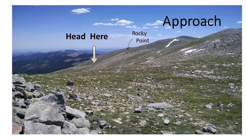
There is no trail to follow across the sloping alpine tundra: locate a somewhat prominent rocky point (see “Approach across the tundra” photo/map), and head below this (left or east) to a break in the topography where the slope changes form steep to lower angle. When you see a lake in the valley below, head slightly right then directly toward a second lake to walker’s right (west) higher in the drainage. When you reach the cliff, hopefully you’ll be slightly above (right/west) of the climb from where you’ll descend left along the precipice to the staging area (see “Looking down on staging area” and “Staging area with cairn....” photos). If too far left, you’ll need to walk back up and around the head of a cleft to the staging area which is on an indistinct point. You’ll feel lost until you’re at the staging area, and GPS coordinates are very helpful: N 39.57452, E -105.61441, elevation 12,440.
For the one climb and variation on the cliff, Kidding Around, and KA Right Variation, I’ve approached them by rappelling down the climb from anchor bolts on the rim, but this requires a short 4th/5th Class downclimbing pitch which is inconvenient (for details see the Route Description/Location). An alternative approach is likely possible by setting a gear anchor farther west along the rim to avoid the 4th/5th Class approach and rappelling to the sloping ramp climber’s left of the climb. Another alternative is to descend the 3rd/4th Class ramp leading to the base of the climb, but this is an exposed grovel and will likely feel sketchy with packs. The ramp is a complex series of sloping ledges and steps rising to the rim significantly west (100 yards?) of the staging area described above, and is marked with a medium-sized cairn (no photo). Note that the ramp can be used for an escape if necessary.

 Continue with onX Maps
 Continue with Facebook