International
> Europe
> Spain
> Aragon
Guidebook- Escalades a Ordesa by Christian Ravier and Remi Thivel I presume that Christian is a decendent (son, nephew, grandson?) of Jean Ravier who made the first ascent of Tozal del Mallo in 1957. This was the first major climb of any of the walls of the valley. [
Voie ("route")
Ravier 10 pitches, TD 350m 6a+ (5.10c) , obligary V+ (5.10a) ] Written in Spanish and French , but with excellent topos that will guide you well even if you don't read either language. And do you really need a translation of "..
.logique et tres belle /
logico y muy bonito" ? Available in shops in Torla for between 26 and 30 Euro. I think I counted over 250 routes,
all Trad, in this book.
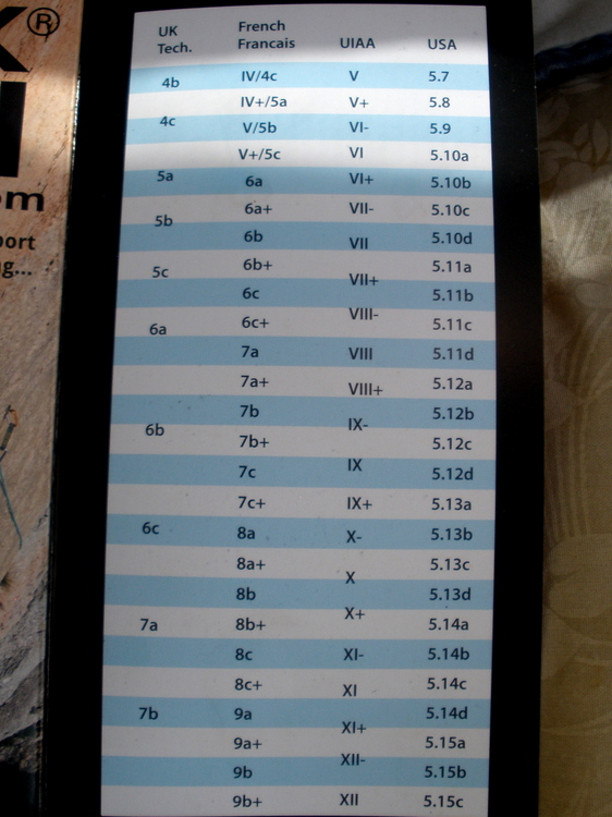
You should realize that the Roman Numeral grades ("V, V+) are French, and not UIAA ! A "V+" is about 5.10a in French system, not the 5.8 it is in the UIAA. The chart below is from a different guidebook, but shows the conversions.
There is an out-of-print (1990) English guidebook to the "whole" Pyrennes, which is still available from shops in Europe through Amazon. He covers Ordesa and Riglos. Topos and verbal descriptions are given for a few of the older, more classic climbs in the areas covered, together with interesting British humor.
There are four sport climbing areas currently developed. No guidebook, but a visit to the local "guide" climbing shop in Torla will be very productive. The guide we spoke with had an excellent command of English and was all too happy to produce the sheet of sport climbs. A copy of this can be found in the sub-area "Sport Climbs".
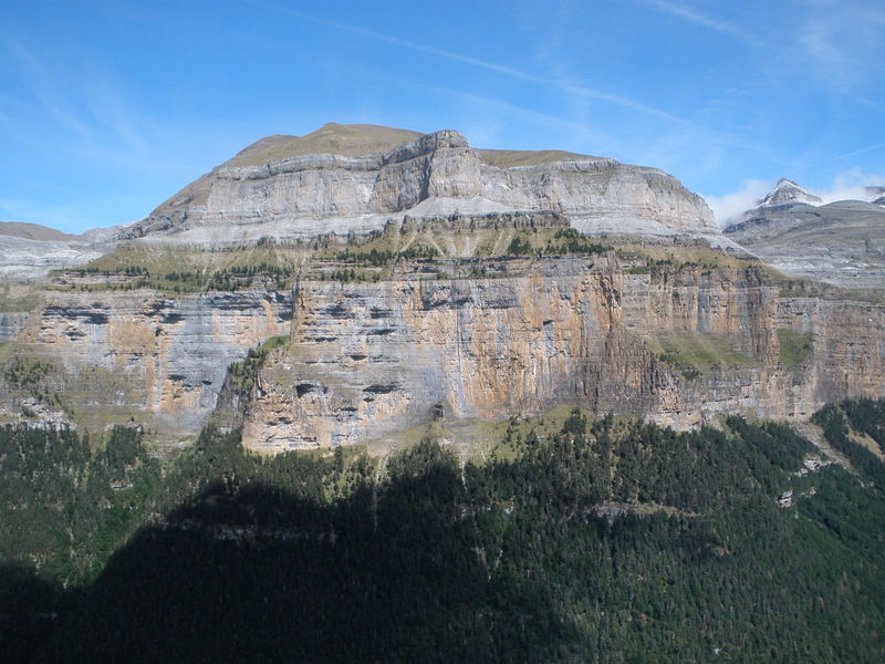
Just an amazing place! If you're from the Northeast USA imagine taking the "big wall" section of Cannon cliff (from "Sam's Swan Song" to roughly "Moby Grape" ) slicing it apart as a cliff; now take 20-25 or-more of these and put them side-to-side, and while you're at it tilt them a bit so that "
gear dropped from the 4th belay hits the ground without touching the cliff". THEN, on top of this "mega long" cliff, put a talus field of a couple hundred feet and THEN on top of the talus put 20 or 30 Cathedral Ledges end-to-end...but forget the "North End"...it's too low. What do you have? You have ONLY the East side of ONLY the Ordesa-proper valley.
You still have other mountains and cliffs in the vicinity (like 10-15 minutes drive) Most are trad, but several are sport.
Although to my "granite-trained eye" these cliffs look to be limestone,
they are in fact a hard sandstone. I was told that the grey rock is where the rain hits and washes out the red color (iron) while the rock that retains its red-yellow color doesn't get much rain run-off (i.e. it's overhanging or vertical) or has just fallen off.
The "main town" in the area is Torla. ("Torla-Ordesa") Looming over Torla is a cliff. which, if you put snow on it and took a photo without the trees at the base, would like, for all the world, like the a miniature North Face of Annapurna.
Torla is about 250 km (150 mi) north west of Barcelona "as the crow flys" and 300 km (180 mi.) by road, most of it "interstate-type" highway. From Barcelonia you basically want to get to Lleida (you'll pass very close to Monserrat) , then go northwest to Barbastro, then north on route A-138, then west on A-160 and the side road north to Torla. The roads around and out of Barcelonia are toll roads, so be sure to have some Euros with you. My recollection is that from the airport to the end of the tolls was about 12 to 20 Euros. Very expensive on a "dollar per mile" basis, but there are lots of tunnels.
I would also recommend NOT staying in Barbastro on the way....it just seemed to be "too commercial" while at the same time being too 'small-time-town'. i.e. lots of traffic in a city that hasn't updated its infrastructure in a long time. There was a festival that closed the main street, and even though we were as close to our hotel as "go straight one block and turn left" , it took more than an hour to get there, and at that I inadvertently went down some "taxi-and-resident-only" streets ! (yellow lines on both sides of the one-car-wide streets)
[ ps In Europe our experience has been that Google and Apple maps don't know about "taxi-only" and one-way streets. The real laugh was the directions we got in Venice....doesn't know about waterways that are not really streets either ! ]
During the summer months (until Sept 16th, and again on the holiday weekend around Oct 14th) you MUST take a park bus from Torla into the park. This was about 5 euros round trip. First bus leaves about 6am, then 7am & 7:30, then every 20min or so. Last bus leaves to park "parking" (see maps, to be posted) about 9pm (maybe 10pm in summer??) ; but it's not an impossible walk out to the public road (about ___5 miles -CHECK ) and the smaller "on-road-higher" parking lot. (see below)
We were there the first week in Sept 2019 and the weather was perfect, and the tourists at a "moderate" level. One must suppose that in July, and especially August, the usual insane levels of tourists abound. The park road used to be open to the public after Sept 1st, but this date seems to be being "pushed back" later and later into Sept. so check if you plan to go.
No camping is allowed in the park. I do not know the status of "biv's", check with park officials at Park info. center located in Torlo at the huge parking lot....or, perhaps, "ask forgiveness, not permission" ??? NOTE: Many maps show the Park Info center inside the
valley", these are outdated: The info center is now at the big parking lot in Torla.
We saw several "car campers" sleeping overnight at the "on-road-higher" (and MUCH smaller) parking lot located about 1 km north of town, and about 1 km before the Park entrance, and this seemed "OK" with everyone. This parking lot is also the START of the approach to one of the main sport-cliffs in the area, as well as where the trail from the "in-park" parking comes out.
Oh...did we mention that nearly EVERYTHING closes between 2 and 5 pm (some more "aggressive" businesses only 2 - 4 ) That's everything...as in the grocery stores, shops, the Park Info. office, (but not the park bus), even the bars..even when there's a "football" game on TV. Plan accordingly.


 Continue with onX Maps
 Continue with Facebook