
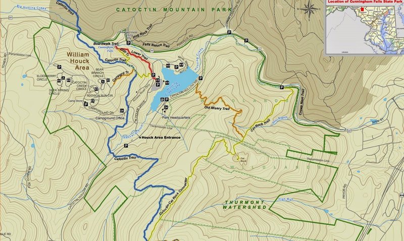
Cunningham Falls State Park is located in the Catoctin Mountains of Maryland. It is divided into two separate areas: the William Houck Area on Route 77 has the lake area, falls, and camping and picnic areas. The Manor Area off Route 15 features camping and the historic Catoctin Iron Furnace.
Outdoor activity is everywhere at Cunningham Falls State Park. Leisure opportunities like swimming, hiking, fishing and canoeing are available. Known bouldering areas are along the Lower Trail and Cliff Trail from the Houck area to the park's eponymous falls, but outcroppings and boulders beckon from deeper in the woods. Much of the park is accessible only via trails or bushwhacking scrambles.
The Thurmont Watershed is included here for geological, geographical, and access reasons. TWS is almost entirely surrounded by Cunningham Falls State park and is located in the North East corner of the park. The area is mostly know for hunting and fishing though more hikers and climbers are discovering it. Access to several climbing areas is just one exit north of the Manor Area off of Route 15. This is a non-fee area.
This area has no known guide though Mountain Projects' community can boast over 100 bouldering and TR climbs.
Park Map: dnr2.maryland.gov/publiclan…
Cunningham Falls Park has two areas with facilities.
The Manor Area is located directly off of the Scenic Byway (US 15). Follow US 15 North from Frederick. The turnoff is well marked and is just past Catoctin Furnace. If you come to Thurmont exits, you've gone too far. No routes are known in this area but exploration is suggested. On the uphill side of the camping loop is a well used trail heading uphill. A 5-10 walk will lead to a small outcrop of rock. There may be short TR and some bouldering problems in the area. There is a $3 day fee drop box.
The William Houck area is a little deeper in the mountains, but features many of the known routes and problems of the park. To get to Cunningham Falls parking lot, from Foxhill Rd (77) turn left onto Catoctin Hollow Rd, then right on North Beach Circle. Lot is on left side after you pass South Beach Circle. $3 per vehicle at kiosk on honor system.
The Thurmont Watershed Area is accessed via fire road that terminates at Pryor Rd. From the south on Route 15, make a left onto Pryor rd, one exit North of the Manor Area exit. Go < 0.2 miles to the unmarked paved driveway on the left. Plenty of shoulder parking. From the North make a right at the Pryor Rd one exit South of Thurmont Blvd. At the stop sign make a left onto Pryor Rd. The fire road is 200 ft on the right. There is no fee.

 Continue with onX Maps
 Continue with Facebook


Baltimore, MD
mountainproject.com/v/catoc… Apr 9, 2017