Vampire Peaks
International
> N America
> Canada
> Northwest Territories
 Access Issue:
 You must pre register before going into the Vampire Peaks as it is part of the Nahanni National Park.
Details
Reservations are required for the Vampire Peaks and the Cirque of the Unclimbables. Please see the link below.
If you have any questions, please contact Nahanni National Park Reserve of Canada at the addresses and numbers below.
Web site:
pc.gc.ca/eng/pn-np/nt/nahan… Email: nahanni.info@pc.gc.ca
Phone: 1-867-695-3151
Fax: 1-867-695-2446
Nahanni National Park Reserve of Canada
10002 100 St
PO Box 348
Ft Simpson, NWT
Canada X0E 0N0
Description
The Vampire Peaks, part of Nahanni National Park, are located in the Logan Mountains, a sub-range of the Mackenzie Mountains, summer home of woodland caribou, mountain goats, Dall sheep, and bears. These rugged peaks were shaped by the last ice age, and are some of the highest in the Northwest Territories. Mt. Sir James MacBrien (9,052’), the second-highest summit in the range, is a formidable highpoint at the apex of a long rock ridge forming the Lotus Flower Tower and Parrot Beak in the well-known Cirque of the Unclimbables. Twenty- five miles to the south of the Cirque stands the tallest peak in the Northwest Territories, Mt. Nirvana (9,098’), home to several easy fifth-class routes and a collection of 2,000-foot walls, possibly only having one established route [AAJ 1966, 2001]. Fifteen miles northwest of the Cirque are the Vampire Peaks.
Perhaps the biggest attraction in the Vampires has been the stunning collection of granite spires flanking the southern aspect of Mt. Appler aka Bastion of Darkness(8,569’). Soaring like high-rise buildings, this trio of columns, known as the Vampire Spires, comprises Vampire Spire (990’), the Canine (600’), and the Fortress (1,500’). Each has a distinctive fang-like summit, with the Vamp and the Fortress side by side and the Canine tucked behind. Two miles east of the Spires is the Phoenix, a 2,600-foot wall on the northeastern aspect of a multi-buttressed 8,530- foot massif called the Sundial aka Mount Dracula. The Vampire Peaks also host half a dozen other impressive granite features, some still unclimbed. Moraine Hill aka Dawn Mist Mtn (8,838’), five miles to the south of the Vampire Spires, has an impressive assembly of south-facing walls and at least one established mountaineering route. A mile to the north of the Spires is a big, possibly unclimbed granite peak dubbed “The Warlock” aka Bastion of Light(ca 8,316’), which also has a formidable south-facing big wall. Vague reports suggest many of the prominent peaks were climbed by fourth-class and easy fifth-class routes in the early to mid-1900s by Buckingham and others. The first difficult rock route was recorded by Mike Benge, Jeff Hollenbaugh, and Greg Epperson in 1994, when they made the first ascent of the Vampire Spire via the Infusion (V 5.11 A2+).
Getting There
It is best to access the Vamps via helicopter, the tab for that can run about $6,000. Contact Warren Lafave, owner of Kluane Airways
kluaneairways.com/unclimbab… Another option is to find your way to the Little Nahanni river and paddle/hike in. The Little Nahanni starts from Flat Lakes and is accessible by truck via the Nahanni Range Road near the Tungsten Mine. Four days on the water (class IV) gets one to a gravel bar by the drainage below the Vamps. Hiking from the river is no easy task; tight forests lead to shrubbery and slick, tundra-covered talus; it takes two days to hike about eight miles up the steep drainage to Vampire Lake and the northern terminus of Moraine Hill Glacier.
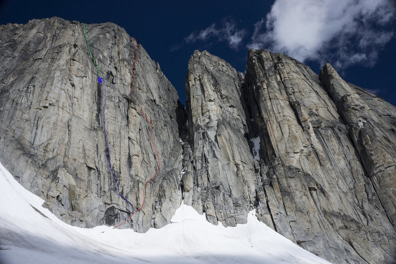
![South face of Moraine Hill aka Dawn Mist Mtn topo. Green-rap rt. Blue-2014 attempt, highpoint marked X. Red-“Fighting Till Dawn” V, 5.11- R, 460m – Dawn Mist Mountain aka Moraine Hill; 2nd ascent of the peak and the 1st ascent of the south face. FA Pat Goodman, Jessa Goebel and James Q Martin 7/19-20/15]()
[Hide Photo] South face of Moraine Hill aka Dawn Mist Mtn topo. Green-rap rt. Blue-2014 attempt, highpoint marked X. Red-“Fighting Till Dawn” V, 5.11- R, 460m – Dawn Mist Mountain aka Moraine Hill; 2nd ascent o…
![This image was taken by Jeff Achey from the summit of Red Pyramid located southeast of the Sundial/Phoenix.<br>
<br>
Numbers correspond with those on the Google Overview map.]()
[Hide Photo] This image was taken by Jeff Achey from the summit of Red Pyramid located southeast of the Sundial/Phoenix. Numbers correspond with those on the Google Overview map.
![Overview of the Vampire Peaks. Created from a Google Earth image by Pat Goodman 2015.]()
[Hide Photo] Overview of the Vampire Peaks. Created from a Google Earth image by Pat Goodman 2015.


 Continue with onX Maps
 Continue with Facebook