West Rattlesnake Slabs
New Hampshire
> Lakes Region
 Access Issue:
 Seasonal Closure - Spring
Details
The trail is often closed in the Spring until mid-may to keep the hordes of tourists off the beautifully manicured trail until it settles again.
Description
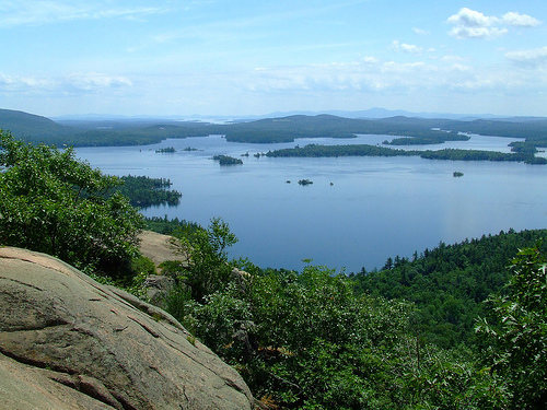
Hordes of tourists show up at the top of this thing every year, but few realize that the slabs below are a whole other experience to be had.
This south-facing cliff offers pretty excellent one to two pitch slab climbing. The rock and climbing style feels very similar to that of Whitehorse, with the same rock type and incredible friction, but suffers from not being climbed nearly enough (hollow flakes, and occasionally crumbly razor crimps). Most of the climbs here are going to feel relatively run out and exposed above the trees, due to a lack of bolts (as of right now). Hollow flakes are relatively frequent here, and produce a pleasant acoustic sound when drummed on. Sometimes the gear is great, and sometimes you don't even know why you're bothering to slot that micro-cam. The top of the cliff has enough trees to find good belays, so remember your slings or webbing. Tri-cams are your friend at this crag. Walking off the top and taking the trail back down is ideal because many of the routes are over 150'.
Still a good amount of potential here, so bring your gear and record some ascents!
Note: People have climbed here before, there aren't any rap-anchors or leftover tree-tat, but there are at least four bolted routes up the very steep slab on the far right side of the cliff. As I have no data on them, I'll assume that they were sent at some point, and then forgotten. I didn't put a huge effort into sending them because of lichen, but the bolts feel strong and I did fall on some of them. I may go back to rap and scrub them, but if anyone has any information on what they are, add it here or pm me. I think that at least two of them are in the 5.11+/- range or harder.
Getting There
From the intersection of Rt.3/Rt.25 and Rt.113 in Holderness, head North on NH 133E for about 5.5 miles, the parking lot for Rattlesnake will be on the right (across the street is the parking lot for Mt. Percival).
Follow the trail (essentially a super-highway) to the beautiful view. The walk in is less than a mile.
To get to the base of the cliffs walk to the right and follow a semi-beaten path down. Rapping from the top of the cliff with a 60m rope will not get you to the bottom in all places. A 70m may, but it would be better just to walk down.
Routes from Left to Right


 Continue with onX Maps
 Continue with Facebook