
 Continue with onX Maps
 Continue with Facebook


Panther Gorge Rock Climbing
Routes in Panther Gorge

|
All Battered Boyfriends T 5.7 5a 15 V+ 13 MVS 4b PG13 |
|
|
All Ryled Up T 5.7 5a 15 V+ 13 MVS 4b PG13 |
|
|
All Things Holy T 5.7 5a 15 V+ 13 MVS 4b PG13 |
|
|
And Then the Judgment T 5.9+ 5c 17 VI 17 E1 5a |
|
|
Anorthofright T 5.9- 5c 17 VI 16 HVS 4c PG13 |
|
|
Anorthosite Overcast T 5.11a 6c 22 VII+ 22 E3 5c |
|
|
Belshazzar's Fate T 5.8 5b 16 VI- 15 HVS 4c PG13 |
|
|
Bushy Pussy T 5.9+ 5c 17 VI 17 E1 5a |

|
Castle Column T 5.9 5c 17 VI 17 HVS 5a |
|
|
Cat on a Wet Tin Roof T 5.8 5b 16 VI- 15 HVS 4c PG13 |
|
|
Climb After Slime T 5.8 5b 16 VI- 15 HVS 4c PG13 |
|
|
Cracks of My Tears T 5.10a 6a 18 VI+ 18 E1 5a PG13 |
|
|
CrazyDog's Halo T 5.8 5b 16 VI- 15 HVS 4c PG13 |
|
|
Eye for an Eye T 5.8 5b 16 VI- 15 HVS 4c |
|
|
For Whom the Lichen Tolls T 5.9 5c 17 VI 17 HVS 5a PG13 |
|
|
Galaxy of Tears T 5.9 5c 17 VI 17 HVS 5a PG13 |
|
|
Had the Radish T 5.8+ 5b 16 VI- 15 HVS 4c |
|
|
Haycrack T 5.3 3+ 10 III 9 VD 3a PG13 |
|
|
Kitten's Got Claws T 5.7+ 5a 15 V+ 13 MVS 4b PG13 |
|
|
Less Than Zero PG T,TR 5.5 4b 13 IV+ 11 MS 4a |
|
|
Luceo Non Uro T 5.8+ 5b 16 VI- 15 HVS 4c PG13 |
|
|
Marcy’s Great Chimney (aka Empty Tomb) T 5.8 5b 16 VI- 15 HVS 4c PG13 |
|
|
Margin Slide T Easy 5th 1+ 3 I 5 M 1c PG13 |
|
|
Moonraker Runout T 5.8+ 5b 16 VI- 15 HVS 4c R |
|
|
Nothing but the Rain T 5.9+ 5c 17 VI 17 E1 5a R |
|
|
One for the Boys T 5.9 5c 17 VI 17 HVS 5a PG13 |
|
|
Panther's Fang T 5.8+ 5b 16 VI- 15 HVS 4c PG13 |
|
|
Panther's Pinnacle T 5.9 5c 17 VI 17 HVS 5a R |
|
|
Paws Off T 5.8 5b 16 VI- 15 HVS 4c PG13 |
|
|
Pioneer Anomaly T 5.8 5b 16 VI- 15 HVS 4c PG13 |
|
|
Practically Roadside T 5.9 5c 17 VI 17 HVS 5a |
|
|
Predatory Instincts T 5.9 5c 17 VI 17 HVS 5a R |
|
|
Pride, The T 5.9- 5c 17 VI 16 HVS 4c PG13 |
|
|
Promised Land T 5.8 5b 16 VI- 15 HVS 4c PG13 |
|
|
Psalm 23 T 5.7 5a 15 V+ 13 MVS 4b PG13 |
|
|
Ranger on the Rock T 5.6 4c 14 V 12 S 4b R |
|
|
Revelations T 5.8+ 5b 16 VI- 15 HVS 4c X |
|
|
Rumours of War T 5.9 5c 17 VI 17 HVS 5a R |
|
|
Slab the Impaler T 5.9 5c 17 VI 17 HVS 5a PG13 |
|
|
Slacker Cracker T 5.9 5c 17 VI 17 HVS 5a PG13 |
|
|
Tail of Redemption T 5.7+ 5a 15 V+ 13 MVS 4b PG13 |
|
|
Throne to the Lions T 5.9+ 5c 17 VI 17 E1 5a R |
|
|
Tomcat T 5.8+ 5b 16 VI- 15 HVS 4c |
|
|
Trigger Warning T 5.10b 6a+ 19 VII- 19 E2 5b PG13 |
|
|
Watery Grave TR 5.10a 6a 18 VI+ 18 E1 5a |
|
|
Windjammer T 5.7 5a 15 V+ 13 MVS 4b |
|
|
Wreck of the Lichen Fitzgerald T 5.8+ 5b 16 VI- 15 HVS 4c PG13 |
|
|
Wrecking My Zen T 5.9 5c 17 VI 17 HVS 5a A0 |
|
|
You Moss be Kidding Me! T 5.7 5a 15 V+ 13 MVS 4b PG13 |
| Elevation: | 3,866 ft |
| GPS: |
44.11333, -73.90655 Google Map · Climbing Area Map |
| Page Views: | 45,611 total · 383/month |
| Shared By: | Kevin MudRat MacKenzie on Jul 16, 2014 |
| Admins: | Morgan Patterson, Kevin MudRat MacKenzie, Jim Lawyer |
Description

Last route added: 2023 February 12 (Manky Lynx).
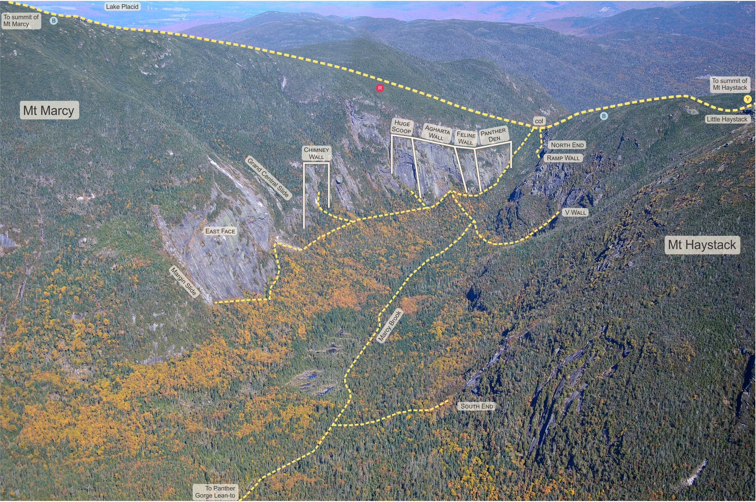
Panther Gorge lies between New York's first and third highest mountains, Mts. Marcy and Haystack. This area hosts some of the most remote backcountry traditional climbing in the Adirondacks. As a dayhike, you’ll amass nearly 19 miles, 4,500 feet of elevation gain over 13-22 hours depending on conditions (yours and nature’s). Once there, the rock quality is excellent with a view that's awe-inspiring.
There are a total of 80 routes (click for spreadsheet) in Panther Gorge; 60+ new routes have been added on Marcy and Haystack during the last few years including 24 ice/mixed climbing routes. Rock climbing routes range from 5.3 to .11d YDS with most falling between 5.7 and 5.9. Ice/mixed routes go up to WI5/M5+. Earlier routes not listed here may be found in Adirondack Rock.
For detailed descriptions of the gorge, trip reports and other resources visit Adirondackmountaineering.com .
Route Line Photos
courtesy of ADK Rock & MudRat
* Marcy-Overall of Panther Den, Feline, Agharta, Huge Scoop
* Haystack-Pillar & Ramp Wall Areas
Additional Resources
*PANTHER GORGE Book (2019)

*Mosaic Collection;cid=7C2FB7A58FF611DF - High resolution distance photos or aerials with inset detail photos and route line may be displayed or downloaded. This also includes about 70 slides, but you may display by filename and scroll to the technical lines. Each route begins with panther_gorge. The naming convention generally follows this layout: “panther_gorge_AREA (Marcy or Haystack)_ASPECT_ROUTE NAME.jpg” .
Articles on Panther Gorge
*Call of Ice and Snow in Alpinist 78.
* The Secrets of Panther Gorge in the Sept./Oct. issue of Adirondac Magazine
* "The Wild Side-Rock Climbing on Haystack and Flash Flood at Slant Rock". Adirondack Outdoors
* "New Highs: Backcountry Climbing in Panther Gorge." Adirondack Life 2016 Annual Guide to the Great Outdoors. 10-13. Print.
* A Climbing Experience in Panther Gorge by Nolan Huther
* "Panther Gorge rocks." Wechsler, Alan. Sept/Oct Adirondack Explorer. 58-61.
* "Panther Gorge: The Remote Adirondack Moderate Mecca You've Never Heard of" Wechsler, Alan. November Climbing. 18-21.
Ice Climbing in Panther Gorge
Ice routes are listed on the Panther Gorge Ice Climbing page.
* Agharta WI4- *****
* Apex Predator WI4-5 *****
* By Tooth and Claw WI4 *****
* Charybdis WI4 *****
* Fly By WI3
* John 3:16 WI4
* Just Nickel and Iron WI4-
* Needle in a Haystack WI3
* Orson's Tower WI3+
* Passion and Warfare WI5/M5 *****
* PG-13 WI4
* Pi Day WI3+
* Ride the Lightning WI5-
* Scylla WI4
* Skip the Lightning WI3+
* Sorry, Kevin WI4
* Spiritus Draconis WI4+
* Waking Cerberus WI5/M4 *****
* One for Me'Lord
* Manky Lynx
Getting There
Copyright Kevin B. MacKenzie and Adirondack Rock
North End Access
From the Garden Trailhead in Keene Valley: Follow the Phelps Trail past Johns Brook Lodge and Slant Rock. Slant Rock Lean-to and the nearby campsites are the most convenient bivy sites from which to attack the gorge from the north. Continue to follow the Phelps Trail to the State Range Trail junction (7.8 miles). Begin bushwhacking a few hundred feet beyond the junction at the top of the pass where the Phelps Trail veers right.To Marcy's Cliffs
Descend south from the Marcy/Haystack col and stay to the right and above the drainage to avoid extensive talus and ledges. You’ll reach the Panther Den, the first wall on Marcy, after about 20 minutes of hard bushwhacking (.2 miles). A 300 foot long glade along the cliff’s base leads to a faint herdpath on the left. The path stays moderately close to the cliffs for about 250 feet until reaching the Feline Wall which is characterized by steep slab with a deep gully to its right. The now intermittent path curves to west over the next 300 feet to the Agharta Wall marked by an obvious cliff below a vast slab. From Agharta continue downhill about 125 feet then make a hard right around a buttress. Bushwhack 200 feet up a drainage stream to the Huge Scoop—the last of Marcy’s north-end climbing walls.Chimney Wall (named in 2017): Continue on contour about 700 south to a glade below the Overhang Slide, a slide with 2 distinct roof systems. Look for the huge chimney on a cliff uphill. Bushwhack up to a gully and follow to wall.
To Haystack's Cliffs
Descend south from the Marcy/Haystack col and stay to the LEFT and above the drainage for everything down to the Ramp Wall. Locate the V Wall by following the "Marcy's Cliffs" herdpath to the Agharta Wall and bushwhacking to a large boulder at (N 44 6.7511’ W 73 54.4918’). Follow the V Wall drainage stream to its base. Expect to spend 60-90 minutes navigating through moss-covered talus, blowdown and dense tree growth.South End Access
*From Adirondack Loj: Park at the Loj (parking fee applies) and hike 8 miles to 4-corners between Mt. Skylight and Mt. Marcy. Descend 1.2 miles into Panther Gorge.*From Elk Lake: Park at the public parking lot near the end of Elk Lake Road in North Hudson. Follow the Elk Lake to Marcy Trail 9 miles to the south end of Panther Gorge.
Several campsites and Panther Gorge Lean-to make excellent sites to overnight--probably my favorite area to camp in the High Peaks.
Restrictions of Note:
*Bear Canisters: Required from April 1-November 30.*Lean-to Rules: Lean-tos mentioned are built to accommodate 8 people. You are OBLIGED to share them if another group comes along.
*Fire: No campfires allowed in the Eastern High Peaks.
*Check current camping regulations for any restrictions.
Weather Averages
|
High
|
Low
|
|
Precip
|
Days w Precip
|
| J | F | M | A | M | J | J | A | S | O | N | D |
| J | F | M | A | M | J | J | A | S | O | N | D |
Photos


All Photos Within Panther Gorge
Most Popular · Newest · RandomMore About Panther Gorge
Printer-FriendlyWhat's New
Guidebooks (13)


4 Comments