Oliphant Boulder Climbing
Use onX Backcountry to explore the terrain in 3D, view recent satellite imagery, and more. Now available in onX Backcountry Mobile apps! For more information see this post.
| Elevation: | 431 ft |
| GPS: |
41.14442, -74.16349 Google Map · Climbing Area Map |
| Page Views: | 12,736 total · 100/month |
| Shared By: | thomasdunne on Oct 18, 2013 · Updates |
| Admins: | Morgan Patterson, SMarsh |
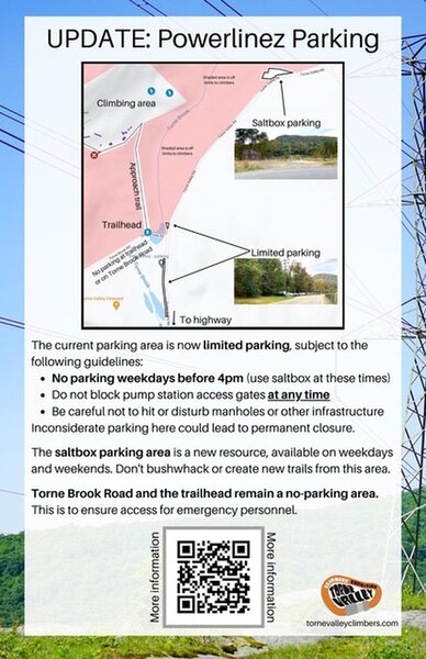
 Access Issue: As of November 2021, there are new parking arrangements. Please follow this guidance.
Details
The current parking area is now limited parking, subject to the following guidelines:
No parking weekdays before 4pm. (Use Saltbox Parking Area at these times).
Do not block pump station access gates at any time.
Be careful not to hit or disturb manholes or other infrastructure.
The Saltbox Parking Area is a new resource, available on weekdays and weekends. Don't bushwhack or create new trails from this area.
Torne Brook Road and the trailhead remain a no-parking area. This is to ensure access for emergency personnel.
Inconsiderate or illegal parking here could lead to permanent closure.
Description

This is a string of boulders all contained roadside as you enter the Powerlinez. The rocks are close together, making it easy for climbers to get on different boulders. Tree cover provides a lot of shade, however, the sun still manages to peek through and thus, the area is well lit. Being at the entrance, especially just off the road, you're likely to see some other climbers or quads/dirtbikes travelling the road (a little more rare).
The rock is similar to the rest of the rock contained in the Powerlinez. It's a bit rough with some sharp edges and nice cracks. This leads to great, strong holds and encourages interesting moves. These rocks provide you with several route options: highballs, cracks, traverses, etc.
Overall, this is a great place to warm up or hang out if the threat of rain is present. At the same time, it is definitely worth spending a day on just exploring what the road has to offer.
Getting There

If you're parked in the big dirt pulloff across from the weigh station on Torne Valley Road, follow the trail in the Northwest corner of the parking lot. The trail will bring you over Torne brook and lead you out onto a dirt road. From the dirt road there are two options:
- Follow the road up to the right, making a left at the first intersection you come to. The rocks will start to appear on your right and after some distance, you'll see a right turn leading you up under the powerlines. This leads to other areas.
- Cross the dirt road and walk up the hill, over the large rock patch. You'll go through some woods but on the other side is the road and the boulders will be to your left and right.
All in all, the trek in takes about 10-15 minutes.
Classic Climbing Routes at Oliphant Boulder
Mountain Project's determination of the classic, most popular, highest rated climbing routes in this area.
Weather Averages
|
High
|
Low
|
|
Precip
|
Days w Precip
|
Prime Climbing Season
| J | F | M | A | M | J | J | A | S | O | N | D |
| J | F | M | A | M | J | J | A | S | O | N | D |
Photos
All Photos Within Oliphant Boulder
Most Popular · Newest · RandomMore About Oliphant Boulder
Printer-FriendlyWhat's New
Guidebooks (2)

 Continue with onX Maps
 Continue with Facebook


1 Comment