To save paper & ink, use the [Hide] controls next to photos and comments
so you only print what you need.
Sunshine Wall
California
> Sierra Eastside
> Mammoth Lakes Area
> Horseshoe Lake Area
Description
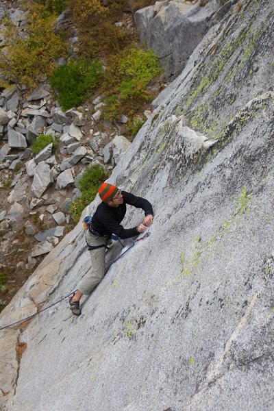
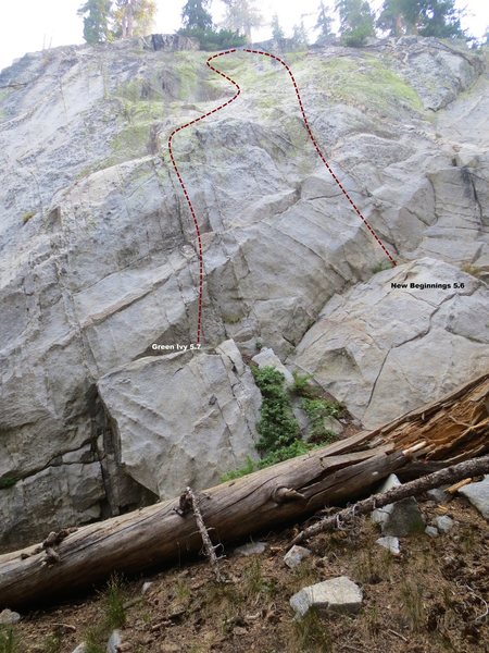
Sunshine wall is hidden in the trees on the west side of the lake and hosts a number of good quality moderate climbs. The wall is made up of a main slab approximately 100' high and a slightly shorter section which holds a couple of routes on the right.
All the routes are on excellent rock with a fine position.
As the name suggests the wall gets plenty of sunshine (at least until 2pm) so plan accordingly, depending on the time of year.
The stand out route of the wall is Little Gem, which climbs beautifully up the right side of the main slab.
With a very short approach (less than 10 minutes walk) and good rock this area will be popular.
Getting There
From the Horseshoe Lake parking area follow the path south along the western side of the lake. Cross over 4 footbridges (see picture below) and just when you cross a small stream (with no bridge) take a right up into the forest.
Follow the faint trail for about 30 yards until another stream crossing and then turn right and follow the stream up a steep slope for a few yards. At the top of the slope head up and leftwards towards the granite outcrop that you will now see through the tree.
[Hide Comment] Getting there ... From the Horseshoe Lake parking (GPS lat long approx N37.6129 W119.0209), the approach is about 150 vertical feet of uphill over 0.5 mile distance (45 vertical meters over 0.85 km distance). Typical approach times in the range of 10-20 minutes.
We found it this way ... Walk on the obvious bicycle path South about 0.35 mile (600 meters), crossing five bridges. Where the bike path crosses a little creek (usually dry) with no bridge (N37.6072 W119.0225), exactly there turn Right off the bike trail onto a faint trail. . (If reach the a bridge with a wood handrail on one side, you've gone too far). . (If you reach the Horseshoe Slabs crag, you've gone way too far).
Follow the faint dirt path generally SSW about 0.1 mile (170 meters) distance, up through the big trees, crossing a couple little (dry) creeks, with some steep sections and curves, to reach the Sunshine Wall. . (my GPS recorded N37.6058 W119.0235, fairly close to what this MP page says).
Aug 9, 2015
[Hide Comment] All but the furthest right route have about 5-10 feet of snow at the base. Still climbable though if you want to get your feet a bit wet.
Jul 25, 2017
[Hide Comment] Bridge update: turn right uphill on faint user path 30' before the 5th bridge which has a Langston Family Trust plaque on it.
Sep 23, 2021


 Continue with onX Maps
 Continue with Facebook


From the Horseshoe Lake parking (GPS lat long approx N37.6129 W119.0209), the approach is about 150 vertical feet of uphill over 0.5 mile distance (45 vertical meters over 0.85 km distance). Typical approach times in the range of 10-20 minutes.
We found it this way ...
Walk on the obvious bicycle path South about 0.35 mile (600 meters), crossing five bridges. Where the bike path crosses a little creek (usually dry) with no bridge (N37.6072 W119.0225), exactly there turn Right off the bike trail onto a faint trail.
. (If reach the a bridge with a wood handrail on one side, you've gone too far).
. (If you reach the Horseshoe Slabs crag, you've gone way too far).
Follow the faint dirt path generally SSW about 0.1 mile (170 meters) distance, up through the big trees, crossing a couple little (dry) creeks, with some steep sections and curves, to reach the Sunshine Wall.
. (my GPS recorded N37.6058 W119.0235, fairly close to what this MP page says). Aug 9, 2015
SLC, UT
Mammoth Lakes, Ca
Newport Beach