Arizona
> Southern Arizona
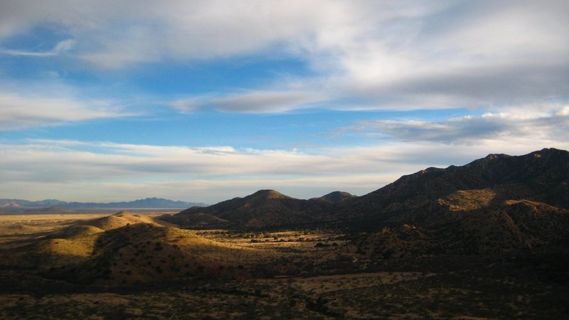
> Cochise Stronghold
The East Stronghold is accessed from Dragoon Road (exit 318 from I-10). It includes a number of excellent climbing areas, the most impressive of which is the Rockfellow Group. Note that much of this area is subject to seasonal closures. These closures have been detailed on the main page for Cochise. Please respect the closures.
A Google Earth .kmz file with an overhead of the East Stronghold can be downloaded at this address:
geir.com/googleearth/strong… Access to this area is a privilege. Be a good steward of Cochise Stronghold by keeping the Leave No Trace principles in mind when visiting here. Below is a partial list of these principles and how they might be applied in the Stronghold. For further information, visit
lnt.org.
1) Travel and camp on durable surfaces. Stay on trails and avoid damaging surface vegetation. Use established campsites.
2) Dispose of waste properly. Pack out litter. Dispose of human waste in a cathole at least 6-8 inches deep and 200 feet away from water. Do not leave toilet paper out in the wilderness.
3) Leave what you find. Leave rocks, plants, archaeological artifacts and other objects as found.
4) Minimize use and impact of fire. If a campfire is constructed use existing fire rings. Do not cut down trees for firewood. Ensure campfires are completely extinguished before leaving.
5) Respect wildlife. If enough people approach or interfere with wildlife, it can be disruptive to animal populations.
6) Be considerate of other visitors. Many other people enjoy the area, including bird watchers, hikers, and horseback riders. They have as much right to be there as climbers.
From Tucson take I-10 east to exit 318.
Take exit 318 and turn right. Head east 3.5 miles to Dragoon.
Cross the railroad tracks and continue on Dragoon Road 7.3 miles.
Turn right on Cochise Stronghold Road. Follow this road for 6 miles.
Turn right on to Ironwood Road.
Follow Ironwood road for 2.7 miles.
At this point you will be at the turnoff for Entrance dome, Batline Dome, Zappa Wall, Owl Rock, the Wasteland, Out of Towners, and Out of Downers. Numerous free primitive campsites are in this area.
Continue .9 miles to the East Side Campground (fee area) and the approach to the other East Side areas.
Note that Ironwood becomes a dirt road but is passable by passenger cars except for after severe rains when the washes can be flowing.
Camping and Accommodations:
There are about a dozen free primitive camping spots, a pay camping area, and at least three rental cabins/houses that can be used. All of them can be located on this page:
toofasttopos.com/googleeart… 

 Continue with onX Maps
 Continue with Facebook


Girdwood, AK
Tucson/DMR
Tucson/DMR
Toofast Topos 2 is a massive expansion on our first book, and details 470 pitches of climbing on 25 formations in the Stronghold. The guide covers the east, west, and southwest regions of the Stronghold, including 113 multipitch routes, a selection of single-pitch crags, the original classics, familiar moderates, killer testpieces, and amazing, never-before-reported lines. Honoring the history, traditions, and inherent ethic of Cochise Stronghold rock climbing, 100% of the beta is firsthand and presented with the utmost detail and precision.
Check out or order the new 430-page book in digital format ($18) or paperback format ($38) at ToofastTopos.com. A discount is offered for those who want both versions.
Geir Hundal Oct 4, 2018