
 Access Issue: You may come across small, silver sensors that are part of a research project on weathering on Cannon. Please do not disturb them. Thanks ! More details can be found at mountainproject.com/forum/t…
Details
Access Issue: You may come across small, silver sensors that are part of a research project on weathering on Cannon. Please do not disturb them. Thanks ! More details can be found at mountainproject.com/forum/t…
Details
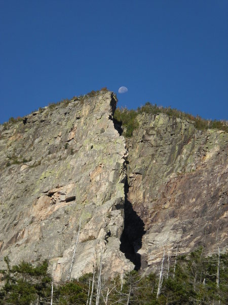
Cannon Cliff is the tallest and most respected cliff in New England. The climbs are long, the weather is bad, and the rock is exfoliating. Every climber who heads up to do a route on Cannon understands that the undertaking is a considerable one.
This is not to say that the routes are bad, however. The popular routes ascend pristine granite and can be over ten pitches long. Just don't stray from your chosen route, as you may find yourself in one of Cannon's many heavily eroded vertical gullies.
Rockfall is a common occurrence on the cliff. The Old Man, a natural outline of a face in the rock and New Hampshire's famous state symbol, fell off the cliff a few years back. An entire pitch, the Whaleback Crack, parted from the face in the 1990's and created a swath of fresh talus at the base.
Gigapixel of Cannon, by Jim Surette
Located in Franconia Notch, the cliff faces east and many a climber has been caught unawares by fast-moving storms coming from the west. Plus, a long talus approach leads to the base and can be heinous if the talus is wet or snow covered.
Do not let the above description dissuade you. Cannon offers the chance for the experienced climber to find alpine serenity on a remote, unforgiving, and challenging wall.
All roads lead to Interstate 93 and I-93 runs through Franconia Notch. The big cliff is on the west side of the road. You can't possibly miss it.
The parking area is on the north end of the cliff. It is only possible to access the lot from the southbound side of 93. If you are coming from the south, head past the lot and get off on the next exit (the Tramway exit). From here, reverse directions and head south into the lot.
For descriptions of Cannon's excellent winter climbs, including the super-classic Black Dike, see Cannon Ice Climbs.

 Continue with onX Maps
 Sign in with Facebook


Plymouth, NH
Plymouth, NH; Lander, WY
Last Sunday, I was up at Lakeview at about 10AM and it was jam packed and backed up by a slooooooooooow group; looked at Weisner Dike and there was a sllllloooooow group there as well.
Considering there was bound to be a huge clusterf*ck at the last pitch, I figured I'd just walk back down and go somewhere else; there is something that looks like a trail for a few hundred feet ... then nothing. I ended up bushwhacking straight down for 95% of the descent and ended up directly on the left side of the parking.
Anyway; word to the wise: That trail is somewhat overgrown. Oct 13, 2011
Lake Placid
New Hampshire
MotWM's viewing area is 400 pixels tall but gigapan allows up to 800 pixels tall. Here is a direct link to a larger viewer. I tried to get it full screen but it took just enough effort for me to lose interest -- this one's good enough. :)
gigapan.com/gigapans/148041…
So Mark... how many beers do you think it will take to get Jim to gigapan Green's?
NOTE - the above link no longer works. See a comment further below for a link that works. R Hall, Admin, Mar 2026 Apr 25, 2014
Toronto, ON
Seattle, WA
In the photos you can see that a big block came out, and there's now a pretty treacherous looking roof/hanging flake directly above the top of the approach trail.
There was also a lot of falling ice today. Wear your helmet and be careful up there!
#longtimelistenerfirsttimecaller Oct 24, 2015
New Haven, CT
Bloomington, IN
Suncook
Natick, MA
publications.americanalpine…
wcvb.com/article/somerville…
publications.americanalpine…
publications.americanalpine…
publications.americanalpine…
publications.americanalpine… Sep 22, 2020
Saranac Lake, NY
Response- the main section, eg VMC, “Sam’s”, Moby Grape, , is usually quoted at 1000 vertical ft, but I’ve never seen an actual, scientific determination. I, myself, have actually wondered if the complete main face of Willard ( eg via the 1929 Std Route) and/ or the 1946(. +/-) “Serpents Head” route on Katahdin’s North Basin might be almost as high, or higher. R. Hall, Admin Jul 6, 2023