Colorado
> Estes Park Valley
> CO Hwy 7 & Tributaries
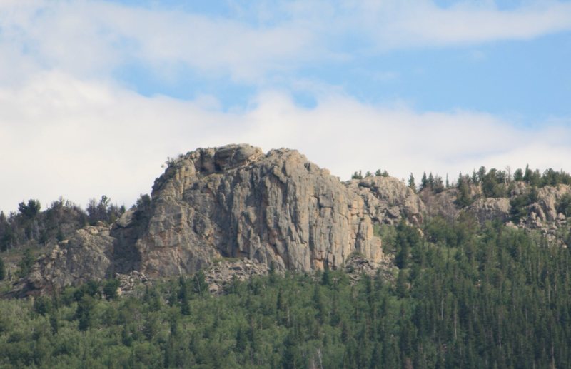
Zappa's Tooth is a 175' high secluded crag with really good rock and an outstanding view of the Allenspark valley, Mt. Meeker, and Wild Basin. Since it faces west, it enjoys afternoon sun and at 9,100' is perfect for the roasting days of summer. Route locations are generally listed with reference to "the Cavity", which is the large recessed alcove in the center-left of the face. The character of this rock is really full of features. The steep sections are often easier than they look. Knobular protuberances are everywhere.
There is still some development left to be done here too, so the adventurous aspect of FAs has not yet been exhausted. Fixed anchors, if any are required, should be placed from the ground up. Think Zappaesque. As folks have already very likely climbed these lines in the past, these are more likely VFAs than FAs.
Zappa's Tooth was born after an evening of
Zappa Plays Zappa in Denver the night before the first ascents. If you're fond of Frank Zappa or fine guitar playing, you'll understand. The route names are of course Zappa tunes, etc.
L->R:
A.
Flakes, 8, 1p, 125', gear.
B.
What Would Frank Do?, 9, 1p, 175', gear.
C.
Dirty Love, 9, 1p, 175', gear.
D.
Sheik Yerbouti, 9 PG-13, 1p, 175', gear.
E.
Central Scrutinizer, 9, 1p, 175', gear.
F.
Titties & Beer, 8+, 1p, 150', gear.
G.
Spinach is my New Lettuce, 8 PG-13, 1p, 150', gear.
H.
Trouble Every Day, 8, 1p, 150', gear.
The crag is located in proximity to The Ironclads and Punk Rock (see the map below). Take CO Highway 7 to Bunce School Road. This road has been greatly improved recently (summer 2011) due to logging activity in the area. Follow Bunce School road to the Punk Rock turn-off and follow this as far as you can. If you have a high-clearance vehicle and some skill, it's possible to drive much closer to this crag on FR 216A, possibly to within a half-mile if you have a serious rig. The road loops, but has a spur at the high point of the loop that leads to the top of the saddle behind the Ironclads. I recommend taking the left fork of the loop - some road building may be required. There is a sign at the saddle that says 216A "Dead End" (see pic below), and some cables have been placed to the right to prevent vehicles from continuing. Hang a right here and follow an old trail that leads up and over the hill to the backside of the Tooth.
EDIT 8/2019: the spur road FR 216A no longer exists. The Forest Service closed it and attempted to obfuscate the remains by churning up the dirt. If you take the left fork of the loop, as soon as you reach the top of the hill, park. You'll see the remains of the road to your left heading S/SW. The old 216A signs are laying on the ground by a tree. The road is only obfuscated at each end, so after hiking about 50 yards, you'll be on the old road. When you reach the old cables (see the new photo below), head up the hill and slightly right to pick up the trail.
The crag is clearly visible across the valley when heading south down the hill from Allenspark.
If you find UTM coordinates much better than lat/long as I do: 13 0458248 E, 4447545 N.


 Continue with onX Maps
 Continue with Facebook


Unless you're into driving (or attempting to drive, then hiking, as we did) the ugly, gnarly, slow 4WD roads, you can hike directly from the north. From where the posted ("View from the north") Tooth photo was taken (which was really from the northeast), drive farther northwest and west on Highway 7. Park at the long scenic pullout (that has big info signs). The Tooth is out of sight from this pullout. Cross the highway and discreetly enter the forest to the south, away from posted private land. Reversing this route provides the quickest escape from threatening weather. Jul 8, 2013
. . . CO
Once you get to the top and before the road heads back north, veer south following the path of least resistance and you'll soon be behind this crag. Drop down the south end to the base and the climbing. Dec 13, 2013
Denver, CO
Glade Park, CO
Boulder, CO