
 Access Issue: 2020 Riverside Fire Damage
Details
Access Issue: 2020 Riverside Fire Damage
Details
Tightly bolted, soft moderate grades, bolted anchors and fun climbing dancing on unique knobs is the game here. Consists of multiple cliffs with the Coethedral formation having the most routes, many being multiple pitch climbs. All routes can be rappelled with a single 60m rope. Becoming more solid as it gets climbed on, it's still cobbly rock that can be crumbly so helmets are a must! Seriously adventurous area for a sport crag, yet still relatively accessible from the metropolitan area. Fairly high in elevation so is snowed in for much of the year, it comes into it's own in the dry and heat of summer. High-clearance vehicles aren't always necessary for access but might be depending on winter/spring road damage.
The Steeple contains a relatively classic 4-pitch sport route to the summit and commanding views of the surrounding area.
Note on Rock Integrity:
The rock in this area is sedimentary in origin, and its strength (like Red Rock, Moab, and elsewhere) is seemingly affected by water saturation. That is, if it's holding moisture, it's more likely to break. Being that overuse will never be a concern here for many reasons, this section is presented more as a warning that holds and even whole blocks may come off if climbing in wet or even damp conditions. Please consider this fact, along with its position at a relatively high elevation on the ocean-side of a mountain range, while making your determinations as to when to climb here.
A vehicle with moderate clearance is recommended. From Portland, take I-205 to highway 224 towards Estacada. Go 22 miles past Estacada's only traffic signal, past mile marker 45 and make a right turn just BEFORE the road crosses a green bridge. From this turn, parking for the crag is just over 10 miles. After turning, you will immediately pass two turn-offs for Indian Henry state park; camping on the left and hiker parking on the right. Go past milepost 2.5 where you will see a beaver pond. From here you are about a mile, as the crow flies, from the cliff. By car, you still have another 7.5 miles to go. The paved road will turn to gravel. Stay right at all forks in the road staying on the better/more obvious road. This will keep you following National Highway development road #4620 (also called The Sandstone road) until it turns into road # 4622. After 10 miles you will see an obvious pullout on the right. This is the parking for the main area. If going to the Steeple, follow directions on that page.

 Continue with onX Maps
 Sign in with Facebook


Portland
PS - To clarify directions: take a RIGHT on OR-224 past mile marker 45, NOT over the green bridge. You will immediately pass Indian Henry campground on the left. Continue up the road, staying right at all junctions, for about 10 miles, until you come to the road closed sign. From here the previously posted directions are good. Oct 18, 2010
Pacific Northwet
For everyone else, as said above although there is currently over 3000 vertical feet of enjoyable bolted climbing on the main weathered knobby silicified tuff-breccia formation: there's lots more to be had, and IF anyone wants to show up and an lay some more pipe and do the hard work have at it. If you don't like bolts don't head out here as every thing but the Salethe Highway route is 100% bolts. There are hundreds of new routes waiting out here to be done in the vicinity. HUNDREDS! . Currently, ALL of the routes can be rappelled with a single 60M rope. No need to haul an extra rope no matter how high off the deck you get. This is a standard it would be nice to keep.
There are some lonely Fixe stainless sport anchor rap stations that don't have bolts to them off to the right (see photo, anchors marked with XX). These are "want ta be routes". If you find an anchor set and get in the mood, please jump in, bolt and finish the line. I uploaded a picture showing those anchors I put in. I was planning on doing them but ripped up rotator cuffs on both shoulders led to running out of mental juice. (Also, I like climbing cracks and there are none within miles of this spot:-) They need to get done, so Git her dun!!! We were using 1/2" x 6-1/2 or 7" long stainless steel wedge anchors, I have some left over if you need some to do a new route feel free to contact me and I'll make you a deal.
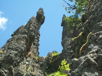
When Ben Priestly (who found the place and turned me onto it -thanks again Ben!) and I first saw it we thought that the main formation looked like a classic Gothic European Cathedral so that was our name for it. There are 2 large spires in the front (Dragon's Spine and The Old Witch) which give the place a total classic gothic cathedral look. As there are "Cathedrals" in about every state, 3 or 4 in Yosemite, my local brobhams soon morphed the name into Coethredral due to the fixation I had on the place. LOL.
The general rule of thumb that Ben wanted and is now tradition is that if anyone thinks an existing route needs bolts, discuss it with the others currently climbing out there and put them in. BAMM:-)! Just do it. Although in other places the tradition is that the FA party gets consulted, Ben had wisely suggested that the more appropriate group to consult for this location is whomever the active/current folks hanging and climbing out here are. I agree and think it's a better tradition than trying to find the FA and asking permission. Given the more remote nature of the area more bolts are better than less, and some of the early routes we did just need more bolts anyway. Given that perfect clipping stances of last year can become tomorrows no place to rest stance in 2 seconds or less, it is even more critical to pull the trigger on a new bolt (so to speak LOL) fast. Just make sure that whomever the current locals or fanatic fans are, they get asked before you drill. Don't make it a big deal if someone else pulls the trigger without asking you your opinion and if they put in an extra bolt you don't like, simply don't clip it.
We didn't want there to be arguments over stupid crap like that out here, and our most fervent wish and hope is that tradition can continue. If we would all treat others the way we all want to be treated life will be sweet for everyone.
New route potential is everywhere. On the main cliff and all these other cliffs and pinnacles you'll see all over just by stepping out of your car and spinning your head around 360 degrees.
Here's a pic below of the end of "The Nave", the area above the main cliff. It stretches around the corner out of sight. Currently as I type this there are NO routes at all and there could easily be 40-60 totally fu*ing rad bolted routes about 40-60' tall in the range from 5.6 - 5.13+.:
All these Oregon climbers are just sleeping on this unbelievable spot and it's only 60 miles from town! If any Colorado climbers saw this place....Sh*t, if someone like Bobby D (Bob D'Antonio) even caught a glimpse of this area in his rear view mirror he would shit on his car seat while reaching for his rotohammer in total shock at the new route potential. If he had the rotohammer and the bolts he'd have 200 routes in here before he went back to town at the end of the day. There's new route potential everywhere and although the lower ends of the grades would start at less than 5.4 which any old guy could haul his fat ass and man-boobs up, there's some crazy 5.15 overhangs that would even give Sharma a woodie if he saw them. With everything in between too. Waiting.
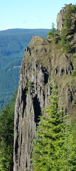
The Steeple, for instance, has only 1 (easy) route up the back side and the potential to have many many more, much longer @ 250'-400' to the summit (and better) routes than Frenches Dome.
Check out the a glimpse of the top of the Steeple (@ 200' of the lower part is not visible), viewed from the front in this pic below. Remember: what you are looking at is only the very top of a 400' high line and is still VIRGIN.
Is that not sick? (good way sick, not vomiting pea soup sick)
Thanks for getting the info up for folks to go hit it Adam, did I tell you that YOU RULE!!!!? If the mods could fix it back the way you had it before they screwed it up so people can add info under the individual routes it would be appreciated. It's probably an ice climbers dream in winter. Even in winter when the road is snowed in the hike/ski in directly up Sandstone creek from the 1500 foot level near Indian Henry to the base is only @ 1 mile (via topo-I haven't done it), and as the Clackamas River Highway elevation is only @ 1500' the road is generally open. It would be a short ski, snowshoe or snowmobile ride up the 4620 road to get some ice climbing laps in.
Tim Olsen will be getting this location into his next Portland Rock Climbs books which will be out shortly, and he should have a bunch of other interesting new places to climb as well that few of us have heard about. Tim will have this place all laid out in his book so go buy "Portland Rock Climbs" 1 (and later book 2) when they get out and support the local boyz. My wife use to shake her head and laugh at my fixation on this place. I'm over it now and the place is yours to climb and add some routes. Maybe when I get old I'll be back for some more fun bolt clippin' in an amazingly beautiful spot with some grandkids in tow.
LINK to Tim's web site for the guidebook. portlandrockclimbs.com/port…
(insert Jesse Jackson voice here: KEEP STOKE ALIVE!)
Take care all! Dec 7, 2010
Watch out for loose rock though. It's everywhere up there, and easily the most dangerous part of climbing here.
Mad props to Bill Coe. Jul 24, 2011
Culver Oregon
The snow has melted all the way to the parking lot to Coethedral and their is no snow on the cliff bands above the climbs. The rock was dry and it is ready for another fun summer season.
I camped right in the parking lot and had the place all to myself from Friday night until Sunday afternoon. The solitude was nice. Glad Mike showed up to do some climbing though.
We will be out next Sunday playing and their are a few others that are planning on getting on some of the harder routes. It mostly bolted knobular fun climbing. So many more routes can go up there. May 31, 2012
Portland, OR
I went out here on Saturday, May 4th. The forest service road 4620/4622 is covered in several feet of snow so we had to walk the rest of the way (snow starts about 2 miles from the "parking lot"). Needless to say the route finding in the snow is more difficult than the descritpion would make it sound. However, after a few snowy ordeals we did make it to the crag. It's pretty nice sport climbing for being in the middle of nowhere. But, it is extremely dirty, my partner and I both were hit by rocks we kicked off routes, (bring a helmet!). And while belaying you will be covered in dirt and moss. I think as these routes see more traffic this will turn into a great climbing area. Right now it's a decent climbing area with a great adventure to get there.
We summitted the witch, via excalibur and the Salathe highway, the exposure is incredible. You have nothing around you on all sides and all you can see is trees and hills for miles and miles, its strikingly beautiful and frightening all at the same time.
Excalibur which is an extremely long sport route is very well protected and pretty fun. The 5.10a grade is accurate, I think if the route were shorter it might only be 5.9 but the stamina required to do this thing clean certainly adds to the difficulty. The Salathe highway, is no more than 5.7 and I think the X given to it by the guidebook is unwarranted. You do have to be comfortbale slinging chickenheads however.
Thank you to BillCoe who helped me find the area and his development of the area is a truly heroic effort. The bolts and anchors are all solid and thoughtfully placed. Additionally, having a seat in those green chairs in the cave next to the crag was a welcome rest after the hike in.
I have no doubt I will visit the place again at some point during the summer. I recommend it to anyone who wants a good day of backcountry climbing fun, which should be everyone.
Thanks Bill! May 3, 2013
Minor update to the directions. There are no longer any "road closed" signs or gates at the parking spot for this area. There are 2 pull outs that are in the 10 mile range after leaving hwy 224. You want the second one.
We climbed better than sex and ujahns delight. Both were solid as far as stability of the holds etc, but they were both dirty due to lack of use. They were nice and fun easy routes.
The anchor at the top of better than sex needs work. The right bolt moves side to side, and the left hanger spins on the bolt, but the bolt seems solid. There is a single 1/2" bolt/hanger above the anchor that can be used to back it up.
I hope to make it back a time or two to try the rest of the routes before the summer is over. Aug 22, 2016
Portland
The right anchor bolt for Excalibur (P2 belay at base of Salathe highway) was spinning and there was a significant amount of play in the bolt. Seemed like all the loading during the rap was on this bolt which could explain it. Someone should take a wrench out with them and tighten it at least. there was a good back up bolt so i wasn't too concerned. The pitch one belay had loose right anchor as well but the bolt still felt solid.
I am in awe of the people that spent the time getting this place developed. Thank you so much! Someone needs to put a route to the top of this place!
Beware loose rock was coming down basically the whole time we climbed. nothing major but wear a helmet if you are at the bottom and seriously consider leaving dogs at home (unless you can get them to wear a helmet) because they could easily get taken out by some rock fall from 300'. Also even though the climbs are fairly low grade this is not a place for beginners, do some multi-pitches and raps elsewhere to get skill set up before heading out to this remote location. I recommend camping. this spot is too far away and too awesome to only spend a few hours there.
probably wont make it out again this season but looking forward to next summer! Sep 26, 2016
A quick trip report from Aug 16th:
The drive from Portland was a stress-free 1.5 hrs. The last 5 miles of gravel road was in fairly good condition with only one spot where a small landslide created an abrupt bump but even a car should be able to pass. The directions posted here are bang-on but we never saw the "road closed" sign. The pullout/trailhead were on the right and there were a couple fire pits in the parking area. The trail was small but in good condition and marked in orange tape. The only difficult place to find trail was at the slash pile. Walk to the end of the slash pile and look for a small faint trail to the right.
We arrived at about 9 a.m. and were in the shade until about 1 p.m. Since it was a weekday, we had the place to ourselves. We climbed Better Than Sex, Rad, Plaid and Glad and Excalibur. Take MORE draws than the guide says because I ran out of draws every time! (With a 70 m. rope you can make it to the anchors and down to the ground on Excalibur but just barely so tie a knot in the end.) All the routes were clean and the the bolts were all new 3/8" placed every 3' or so. One could argue that it is overbolted but considering there is a chance a hold could pop off and a fall on less than overhanging rock would be quite painful, I appreciated the decision to overbolt vs. underbolt. My partner pulled off two small rocks and while belaying, small stuff does fall, so a helmet is a really good idea.
There are wooden tags at the bottom of a few climbs so it is easy to tell what route you are getting on. I found the grades to be soft, (Planet Granite level grades) especially when compared to Smith, but the exposure adds to the excitement level. On the far left side of the formation, there is a cave and what appears to be a great new line up through some yellow lichen.
Had a great time and will certainly be back. Thanks again for all the hard work of those who have developed this awesome place! Aug 18, 2017
Portland, OR
Also, anyone heading out there in the spring, consider bringing some new small wood "plaques" to mark routes, as was done originally. I believe only 'Runaway Weasel' and 'Better Than..." are currently marked with very faded boards. Oct 18, 2018
Portland, OR
Portland, OR
Portland, OR
To be clear, NF-4620 is a longer road, but this is a short connection (half mile?) between two junctions. You can approach from the south legally and without gates.
There was a dirt berm blocking the continuation of NF-4620 where it meets NF-210. Someone tore it down enough (three hoodlums from the looks of it, I wouldn't know) to cross with high clearance. We drove down that, moving rocks and chainsawing logs, getting very hopeful.
Then, a much larger berm and straight up trees growing out of the road. We walked from that point to the next junction (Fish Creek Mtn TH). Along the way we found big dirt mounds and a two-tiered landslide. At the junction: signs of recent FS activity.
Long story short: no backdoor access. Wait patiently or take bikes. Aug 22, 2023
Milwaukie
Portland, OR
Sign says no motorized vehicles, however as of now USFS website lists the road as open seasonally (not winter).
I personally broke three holds on two routes. Belayer absolutely wear a helmet and get out of the way. Fun crag, grading is very soft, would go again.
Unfortunately if you go in August your climbing will be severely distracted by thimbleberries, black raspberries, red huckleberries, etc. Aug 7, 2024
Portland, OR
Sections of climbing are incredibly dirty, making those sections harder than the route grades. But the majority of what we climbed was mostly clean and super fun. The bolts all look shiny and in great condition - some hangers spinning, but nuts wouldn't budge and there was lots of thread above them.
During the rap, we heard someone screaming from back towards the road, and it lasted until we got back to our car. Turned out to be someone that had lost his friend, seemingly intoxicated, and blasting his truck alarm. We helped by using a Garmin to signal emergency services, only for his friend to stumble out of the woods a few minutes later shirtless and covered in dirt, having fallen and rolled down the entire hillside into the creek below. He said he was okay and to call off emergency. Be careful out there, and please don't drink and drive. Jun 12, 2025