Mountain Project Logo
To save paper & ink, use the [Hide] controls next to photos and comments so you only print what you need.

Mahoosuc Notch Ice

New Hampshire > NH Ice & Mixed > - Lesser Notches of t…

Description

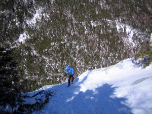
On the south side before the notch, uphill is a 60ft. cliff with three distinct (WI 4-5) flows. I went in to the notch early in the winter before the snow was deep and camped near the trail.

Getting There

[ Editor's Note: Mahoosuc Notch with its huge boulders on the trail is known as perhaps the "toughest" section of the entire 2000-mile Appalachian Trail. It is actually in the state of Maine, not NH.]

If Success Pond road is open, take it from Berlin, NH about 10 miles to the turn off for Notch Road / Notch Trail. Park where you can and hike up Notch Road. Depending on where you park, Bear right if North Rd splits. About 1/2 mile from Success P R, and shortly after crossing the main stream, Notch Trail Branches off to the left.  After about 2 1/2 miles this intersects the Appalachian Trail ( the Mahoosuc Trail). Turn left and soon enter Mahoosuc Notch.  Bradley describes there climbs on the right ( southern) side of the notch.

  For more specific directions to Success Pond Rd see the entry for North Bald Cap.

Bradley went in early in the winter when the road was still passable. Even then, figure it will take the better part of an hour to do the 10 miles. 15-20 mph is good speed even in the summer on Success Pond Rd. Needless to say, dont get caught by a deep snowstorm 10 miles in on an unplowed road!

If the road is impassible (and you don't have access to a snowmobile !) the next most logical approach is probably taking the Appalachian Trail up over Old Spec Mtn ( up 2500 ft) from Maine Rt 26 in Grafton Notch about 7+ miles into Mahoosuc Notch, coming in from the North rather than from the west via Success Pond Rd. R Hall, edited with permission of B. White.]

Photos [Hide ALL Photos]

thules on the left; the main wall wrapping around to the right; DC photo
[Hide Photo] thules on the left; the main wall wrapping around to the right; DC photo
topo, sunnyside
[Hide Photo] topo, sunnyside
Jim rappelling the left end of the main wall; lower sunnyside is just visible on the right edge; the 100' center sunnyside flows look tiny from up here...
[Hide Photo] Jim rappelling the left end of the main wall; lower sunnyside is just visible on the right edge; the 100' center sunnyside flows look tiny from up here...
topo, north face
[Hide Photo] topo, north face
Dan on the class act climb on the left end of the Berlin wall
[Hide Photo] Dan on the class act climb on the left end of the Berlin wall

Comments [Hide ALL Comments]

[Hide Comment] Over the past decade, Dan Cousins, Dave Custer, Jim Paradis, and Susan Ruff have extensively explored the ice climbing potential of Mahoosic Notch and climbed some 40 pitches of ice in Mahoosic Notch. We find the ambiance in Mahoosic Notch to be unique and hope that the area will continue to foster a sense of adventure in those who choose to make the pilgrimage.

MAJOR AREAS

o The Berlin Wall A discontinuous line of ~30 meter high ice flows, grades 2-5.

o The Main Wall Up to ~800 ft. The ice is unreliable.

o The Thules This upper band of north facing cliffs presents the greatest approach challenge; grades 2-5. A lower band of thinly iced slabs provides access to the upper slabs.

o Sunnyside lower, middle, & upper: ~30 m climbs, grade 3 to 4+. Reliable & pleasant—a good bet for a chilly day. Dec 14, 2010
[Hide Comment] I would really like to get all of your fun hard work up and readable with descriptions and ascents, but I don't have areas available in the choice boxes. I was at lower Sunny side.
Hey administrators, possibly we can begin over, with these folks in command of areas, since their knowledge of this region surpasses mine, please? Feb 27, 2013
M Sprague
New England
[Hide Comment] Sure, if you would like, Bradley, but it doesn't look like Dave Custer has been on for a year and a half. I could send him an email if you would like, unless you would like to. Feb 27, 2013
M Sprague
New England
[Hide Comment] Bradley, where do you park and hike in from, Success/York Pond Rd or Grafton Notch? I am looking at maps and my old AMC guide and am having a little trouble figuring out how you got in and from which side you are approaching the notch. This is actually in Maine, correct, and the climbing is on the northern side of the notch? Feb 27, 2013
[Hide Comment] I've heard from some hiker friends that there are lots of boulders in the area. Does anyone know if people have bouldered here or if a reasonable potential for development exists? Jul 8, 2013
[Hide Comment] Man, it was long ago. I came in from the Berlin side or at Gorham. Went east on a logging road many miles to trail head that goes to the trail to the notch. It was a few miles to where I camped and a big half mile to the notch. I didn't explore much and didn't see much, so I missed out on some nice climbs. Its okay the area description. Easy place to understand topographically.
The trail through the notch is nothing but climbing through or over boulders, they are everywhere in the notch. Feb 4, 2014
[Hide Comment] This makes the fourth area (I'm aware of) I submitted that retain my writing but not my identity. Unbelievable! All of my submissions with purpose were shared for share alike. That is unlike yours serves yours. Jan 14, 2017
[Hide Comment] I agree with Bradley; the text for the Mahoosuc Notch area is his; it was not submitted by me. Jan 16, 2017
M Sprague
New England
[Hide Comment] Dave, if I remember correctly, the page was switched over to you to make it simpler for you to do reorganization/editing and add further information. I guess the editing never happened. I'll switch it back to Bradley if you guys would like. Edit and additional information suggestions can always be posted using the 'improve this page' button. Thanks for the very useful topos. Jan 16, 2017