
 Access Issue: 1. RAIN & WET ROCK 2. DANGER OF EROSION
Details
Access Issue: 1. RAIN & WET ROCK 2. DANGER OF EROSION
Details
Climbing After Rain | A Guide to Wet Rock - Sender One Climbing.webloc
DO NOT CLIMB WHEN WET!!! LET THE ROCK DRY BEFORE CLIMBING!!
Texas Canyon, located in the high desert, between Santa Clarita and Aqua Dulce, consists of a collection of large conglomerate domes, isolated rock formations, and boulders nestled in the rolling hills of canyon country in NW Los Angeles County. Texas Canyon or Table Rock, the USFS designation, and the nearby Rowher Flats OHV Area are managed by the USFS, in cooperation with Los Angles County, and the State of California. Texas Canyon lies at 2500 ft in elevation. Currently, Texas Canyon hosts 190+ climbing routes from 5.0 - 5.13b. Most routes are bolted sport routes, and require only quick draws and lead to Fixe rings, chains, or shuts/hooks. A 60 meter rope is useful in climbing and descending most formations, some up to 200 in height.
Climbing After Rain | A Guide to Wet Rock - Sender One Climbing.webloc
The use of the Texas Canyon/Rowher Flats area spans several thousand years when local springs and the diverse landscape provided sufficient water and food to support the Tataviam Indian village. The area has been popular with OHV enthusiasts and rock climbers since the early 1960s, as evidenced by old rusty bolts and fixed pitons on some of the formations. Loomis, Leventhal, and Draper began putting up routes as early as 1992. Savage established several moderate sport routes between 1998 - 2000. Many of the moderate lines were filled in by Chapman and Neal from 2010 -2014. The area was closed for eighteen months, due to the October 2007 Buckweed Fire. The climbing at Texas Canyon can be characterized as bolted sport climbing on abundant pockets, knobs, and inclusions or weathered cobbles protruding from the surrounding rock. Climbing varies from low angle slab to steep overhung faces. The area has become popular due to the range of quality, well protected moderate routes and the short approach. Climbing is possible year round, with the exception of the coldest and hottest days. A cautious approach is advised as the conglomerate is friable and hand and footholds frequently break. Use of a helmet can not be overemphasized, especially for belayers.
An article in the Southern California Mountaineers Association (SCMA) Cliffnotes (August 1999), by Savage, provided the first documentation of climbing routes at Texas Canyon. Other guidebooks to Texas Canyon include; Best Climbs Los Angeles by Damon Corso (2014), Southern California Rock Climbing, Vol. 2 by Tom Slater (2013) and Southern California Sport Climbing, 3rd edition by Troy Mayr (2004). While these S. Cal guidebooks provide basic directions, approach information, photos, and rudimentary route topos, none of these guidebooks is comprehensive or current. The best guidebook is Texas Canyon The Climbing Guide by Pam Neal with Ben Chapman (2019). You'll need a copy of this last one since there is no cell reception at the crag to look things up on MountainProject on your smart phone.
THERE ARE NO TOILETS AT TEXAS CANYON, so consider your impact on this fragile environment.
The first time you do a number 2 in the wilderness, it’s intimidating. You’re out in the open, with the bugs and the poison ivy, clutching either a few precious squares of toilet paper or a pile of rocks and (hopefully smooth) leaves. Keep at it, though, and you’ll find it better faster than you think (especially if you can find a spot with a view). Learn the correct way to do your business in the wilderness and enjoy the experience with these tips.
The Gear for Your Rear
Choose Your Job Site
Start searching for your spot before you have to go—trust us, you don’t want to wait until your situation is desperate. LNT recommends popping a squat 200 feet—about 70 steps—from water or trails (don’t get lost). Find a private area with loose, diggable soil. Bonus points for good views.
Ready, Aim, Fire
Your cathole is your personal, single-use toilet. It should be 6 to 8 inches deep and 4 inches wide. Squat low to the ground for optimal aim—hang onto a tree trunk if you need a little support. Pack out your toilet paper in a sealable bag or place it in the cathole if local regulations allow (TP degrades quickly in wet, humid climates, more slowly in dry ones, and not at all in the desert.)
Bury the Evidence
Cover your poop with the dirt you removed from the cathole. Make it look like you were never there. Remember, your trowel should only touch dirt. Wash or sanitize your hands and revel in that weightless feeling.
WAG Bags
Some sensitive wilderness areas such as high-alpine ones, arid deserts, or high-traffic parks require the use of WAG bags instead of catholes. Check local regulations for the area where you’re camping and follow the instructions on the WAG bag’s package. Always use outhouses and pit toilets when available to minimize impact on the land.
Perhaps this should be the norm for those that can't resist.
Enchain / Climb all of the 10a, 10a/b routes in a day at Texas Canyon. The Tens In A Day (TIAD) consists of twenty-one routes as of 5-2-21. TIAD will be updated as new 10a/b routes are developed.
Combined route length: 1,625 ft.
Itsy Bitsy Spider
Leather & Lace
Before The Storm
Endymion
Yellow Rose of Texas
Texas Slotterhouse
Slotterhouse
Kronos
Heart and Sole
El Matador
Mixed Emotion
Diesel
Pin Route
Black Gold
Honeybee
Texas Tea
Tusk
Buzz Killer
Debbie Does Dallas
Let It Bleed
Rhinestone Cowboy
Camping at Texas Canyon is legal per guidelines set by Angeles National Forest. Google "Dispersed Camping Guidelines" to get the latest. Here is a link that specifically covers the area: https://www.fs.usda.gov/detail/angeles/maps-pubs/?cid=stelprdb5318340
Park all night at your own risk. Display your pass to avoid conflict. LEAVE NO TRACE. (as always)
Comment: Everyone has a different definition of camping. It's pretty funny. Drunk and disorderly with a bonfire is how rangers see it. Be more like the bobcat; no one knows you were ever there.

 Continue with onX Maps
 Continue with Facebook


Small Town, USA
Big Bear Lake
I have only climbed a few routes here but I would recommend adjusting the quality star rating system because it seems like we're using some other area (a granite area?) as the datum for the quality ratings, for example I would say that Hyperion is at least 3 stars based upon the surrounding climbs, it has good moves between widely spaced bolts plus a cool hanging belay. Anyway MHO. Nov 28, 2011
Torrance, CA
Los Angeles, ID
It seems the Forest Service loves to play games with the public. Most climbers know that the "Area Closed" signs were removed from Williamson Gorge at least three years ago. Could that be because they really don't have the right to close that area?
Since the court decision earlier this year against the Adventure Pass--the third time it has been thrown out by Federal Court--the Forest Service seems to want to propagate a sort of myth about the pass, even though most of the "Must Display" signs have been removed. All they have to do is put up the proper signs, which I'll bet they realize they have no right to do. "National Forest Fee Area" doesn't mean a thing unless there is further instruction as to what the fee is and what is required of users. And I haven't seen any such thing around Rowher, except for the information billboard about how ORV fees are used. Sep 30, 2014
However, my personal opinion, I think TC is getting overused, just the way Williamson Gorge was getting so crowded in the years before its closure. Climbers, especially beginning climbers, seem to get stuck on a favorite area, like going to the same gym all the time. Echo Cliff was that way for awhile, and now it's often a ghost town. When you get this kind of heavy use, you can expect the land managers to get concerned and want to do something about it. I'd advise spreading out a little--Devil's Punchbowl, Horse Flat, Tunnel Crags, Corpse Wall, Tick Rock, Malibu Creek, Echo Cliff--all an hour or so (or even less) from the city, all acceptable and challenging climbing on our beloved chossite. Oct 1, 2014
Los Angeles, ID
HUMAN WASTE: Pack out yer paper folks. It's the NEW cool thing to do. Bring a zip-lock for this purpose.
Really cool people pack WAG-bags. Oct 13, 2014
Bellingham, WA
There is no camping allowed at the crag, fires are not allowed there, you can not collect the native vegetation for firewood any where in the National forest and for fuck sakes don't throw glass bottles into the fire you should not have made.
I am all for young people getting into climbing but they need to act responsibly or there will be consequences. Mar 4, 2017
No fires are legal. During the lowest fire rating "low" in the ANF, "Wood and charcoal fires in designated sites only, in agency-provided campfire rings and stoves."
You would need a California campfire permit and shovel to be allowed to use a gas stove.
In the video at 1:27-1:29 you can see what is being burned and its not firewood that was brought in. The camera focuses on the bottle in the fire at 1:50. Tanner and Ashley are not using the area responsibly. I posted to ask others to be responsible with using the area. The video was an example of what not to do as it will create problems with the forestry service.
As for being done for decades, so was target shooting. There used to be a dozen or so sites in ANF, including Texas Canyon, for free public target shooting. Irresponsible people got them all shut down.
Mar 16, 2017
Los Angeles, ID
Los Angeles, ID
There is a real danger of conglomerate boulders/inclusions popping out and clobbering people below. When it is dry it's pretty hard.
One exception may be inside the cave. There are a number of difficult sport routes there that get no moisture at all. Mar 8, 2018
Los Angeles, ID
What's the route there left of The Shrike crack on Shrike Temple? Looks great! Please post up. It's not in our guide here.
If you don't come forward with the name, it may forever be known as the Katie Hill route. ;-D May 2, 2018
Yorba Linda, CA
Los Angeles, ID
What is your definition of Camping? There are no adjacent "Campgrounds." No good places to park and camp from your car.
If you backpack in to the crag there are several interesting spots to sleep, eat and leave no trace. Including the cool Chumash Cave on the trail in.
The area is too dry for campfires most of the year. If you do make a campfire, make it a minimalistic "leave-no-trace" campfire and then only in the few weeks of the year after the rains make things green and before the grass matures and dries.
In the early 1990s this area was open to ORV camping, shooting and free-for-all. It was littered with trash, broken bottles, shot up garbage, and bullet casings. Also heavy damage to the land by off-roading. As you can see there is little evidence of this now.
Care for and respect the land. It belongs to you and me. May 14, 2018
Small Town, USA
AF article on areas in crisis:
accessfund.org/open-gate-bl…
I know it's probably common knowledge by now, but it's still worth posting for any that don't know that "impact" applies to everyone. I try to drop deuces before I hit the trail, and I always end up packing out trash that was left by aloof or generally lazy, selfish or inconsiderate people that don't really value pristine outdoor spaces and make a concerted effort to keep them that way as close as humanly possible. I also stay on trails, use hard surfaces/exposed rock to place my pack on and stand on whenever possible to minimize erosion. I try, against every instinct that steers me toward being anti-social, to tactfully approach people that are doing dumb shit and help if I can. This includes:
pooping (yes, I have done that to someone that dropped Scuds mere feet from the wall)
littering
top-roping through fixed gear
making ginormous tick marks
blocking trails with hammocks or other gear
parking like asinine shitheads (I've been called out on this as well)
being generally incompetent with best practices for safety
veering off established trails
Unfortunately, I have seen quite a few people that don't do any of these things, and treat outdoor spaces like a gas station bathroom.
You name it, I've probably approached someone on every issue that involves the dos and don'ts of outdoor climbing at some point or another. I donate to the AF (yearly) and to NRAC every time I visit the NRG (which is a dozen times a year, give or take). I know for the region that I visit the most, there have been public meetings occurring bi-annually for the past year or two discussing a climbing management plan. Given this article, and the general sentiment that land managers have regarding the increasing impact of areas being "loved to death" (although, shitting in a place that you 'love' and leaving it there seems a bit ironic to me), it's likely that we all see more restrictive access and management plans moving forward into the future.
No one likes to approach other people and "correct" them when they're doing something wrong. It's awkward, tense and it sucks. But considering all the organizations and coalitions and Access Funds and AACs out there, and considering that there are so many popular areas that are still "in crisis" despite all these things, I don't see how, as a user group, we can afford NOT to correct people.
The last thing I or any other avid outdoor climber wants is to show up to the crag one day and then "oh surprise, you can't climb here this year because it's now a lottery or limited permit basis now because of all the impact" or something similar. And if you don't think it's heading that way, you're mistaken and/or willfully ignorant. All it takes is one area to implement and have success for that to be a precedent for other areas on how to move forward and mitigate this impact.
I don't climb super hard. I don't climb outside as much as I'd like. I'm not a developer. I'm just a dude that loves climbing and loves the spaces and venues in which I climb. If I approach you outside, just know it's not because I'm trying to be a dick, or trying to impose some sort of authority- and I'm certainly not enjoying it. I'm just trying to keep the worst case (or second to worst case- worst being closure) from happening.
And If I'm doing something jacked up, please correct me. Call me paranoid or silly or whatever you want, but I fear if we don't start policing our own a little more, crackdowns are not a matter of if, but when. Let's help each other out. Donate to orgs, make conversation at crags, get to know people, and be better stewards and correct one another if it's needed.
Thanks
74 Dec 4, 2018
Bishop, CA
Ten Sleep, WY
Pam Neal and Ben Chapman worked together to author this great book and trusted me to layout and publish it on their behalf.
The books should be in hand and ready to ship in early March, and we are taking pre-orders now. Personal copies can be purchased at: louieandersonclimbing.com/
If you are a retail shop and are interested in placing a wholesale order please contact me at louieanderson@live.com
Thank you. Jan 11, 2019
NorCal
I wrote this. Apr 12, 2019
Santa Ana, CA
Thanks Dec 17, 2019
Los Angeles, ID
California
scientificamerican.com/arti… Jun 30, 2020
Los Angeles, CA
Los Angeles, CA
Small Town, USA
edit: We encountered two rattlesnakes at Texas Canyon on Friday. One, near the Hatchery, W. Face, was quite large and the other a neonate, at the north end of the First Corridor near Tethys. Both snakes were admired from a safe distance and remain alive and contributing members of the High Desert ecosystem. May 2, 2022
Santa Clarita, CA
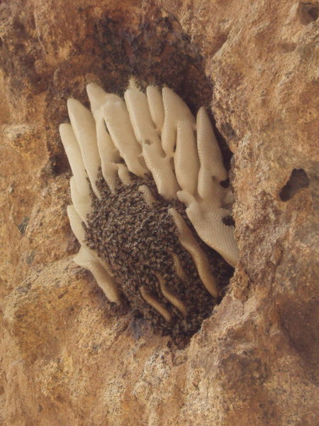
I'm not an insect expert. I understand that bee's are typically a bit more aggressive in late summer/early fall but the level we've seen out there still seems abnormal compared to previous years. My best guess is either the sweltering end of season heat and/or the ground nest of wasps and the Tarantula Hawk that we spotted near the caves on our hike out. Aug 20, 2022
California
Please keep this system in place. If you come up on the area and notice the rocks have been moved, please put them back.
There are other parts of trails where we have built water bars with rocks to divert water. Notice and repair them when you come upon them if you see an issue. Dec 11, 2022
Small Town, USA
For the latest information regarding the status of Rush Canyon Road for access to Texas Canyon and whether the gate is open call:
(661) 269-2808
(661) 478-4987 Mar 24, 2023
Los Angeles, ID
Park all night at your own risk. Display your pass to avoid conflict. LEAVE NO TRACE. (as always)
Comment: Everyone has a different definition of camping. It's pretty funny. Drunk and disorderly with a bonfire is how rangers see it. Be more like the bobcat; no one knows you were ever there.
This text was added to the text for the area above. Jan 29, 2024
Small Town, USA
Small Town, USA