To save paper & ink, use the [Hide] controls next to photos and comments
so you only print what you need.
Purple Wall
Utah
> Wasatch Range
> Central Wasatch
> Little Cottonwo…
> Maybird Slide Area
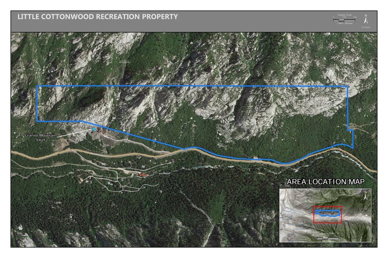
Access Issue: Gate Buttress Area Recreational Lease: Climbs on Church Buttress above vault remain closed
Details
Climbers Partner with LDS Church on Stewardship of Little Cottonwood Canyon Climbing
June 1st, 2017:The Salt Lake Climbers Alliance (SLCA), the Church of Jesus Christ of Latter-day Saints (LDS Church), and Access Fund announce the signing of an unprecedented lease for 140 acres in Little Cottonwood Canyon (LCC). The parcel, known as the Gate Buttress, is about one mile up LCC canyon and has been popular with generations of climbers because of its world-class granite.
The agreement secures legitimate access to approximately 588 routes and 138 boulder problems at the Gate Buttress for rock climbers, who will be active stewards of the property. The recreational lease is the result of several years of negotiations between LDS Church leaders and the local climbing community.
Access Note: The climbs on the Church Buttress above the vault as well as the Glen boulders that have been traditionally closed will remain closed. Please help us steward this area and leave no trace.
The Purple Wall sports several bolted routes on juggy, overhanging quartz monzonite. The area's name is likely derived from the unique purple varnish in sections of the rock. The wall is east-facing and is in the shade after 2pm or so. Rock quality is good, but are still cleaning up. There are some sections of rotten rock, but nothing serious. A gentle breeze picked up once the sun went down. Routes are well protected and most bolts clip from good stances. Worth the hike considering the seclusion and great weather on a hot summer afternoon.
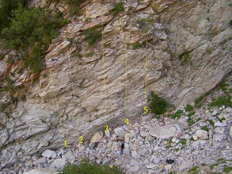
Here are the routes listed in order from left to right:
Look for a lone pine tree between the two "Maybird Avalanche Area" signs. Here, a rock cairn marks the beginning of the trail. Follow the established trail to a rock-filled gulch. A series of rock cairns lead to the remnants of two stone huts. Look left and the Purple Wall will stare right back at you. Plan on moderate hiking of about 20-25 minutes.
[Hide Photo] Topo of south end of Purple Wall: 1. Bubbles & Booze 5.11a 2. Squeeze It Until Its Purple 5.10c 3. Mad Swiller 5.10b 4. The Wine Drip 5.10a 5. Pump It Until Purple 5.9
[Hide Comment] Trust me we heckled Greg every time he used those chains. They would be better suited for hanging bling bling around your neck than holding a climber. Buy more topos so Greg will sack up and buy beefier chains!(hopefully)
Jul 12, 2007
[Hide Comment] the win`0 is the first climb on left purple haze is up gully another 90 feet or so another 90 feet or so is the next 7 climbs
Sep 7, 2007
[Hide Comment] Great wall, an impressive effort to bolt all these routes! If you are a regular LCC or BCC climber, these routes are pretty easy compared to other standard routes. So you could expect to climb two or three letter grades harder in this area in comparison with other areas in the Wasatch.
Jul 11, 2010
[Hide Comment] Since a rock slide early in the summer of 2013 the routes on the purple wall are about 7'-10'shorter. I still find the area a fun afternoon spot just not as tall as it used to be.
Aug 13, 2013
[Hide Comment] A Little Cottonwood anomaly: juggy, short, gym-bolted, shaded, soft-graded (at least for LCC) sport routes. A confidence-inspiring wall, great for a new leader. If proficient at the grade, you can complete the whole area in a few hours.
Oct 16, 2016
[Hide Comment] The approach trail is currently very overgrown, but it exists. I didn't see any cairns either. Watch out for ticks - we saw about 7 when we went, some of them on the wall.
Jul 8, 2023
[Hide Comment] Since the rock slides and washout this year the area and approach have changed somewhat. The bottom of the trail has quite a few downed trees which have both blocked the trail in a few spots and made room for lots of underbrush growth. Bottom half of the approach is now considerably more bushwhacky than before. Top half of the approach has been cleared out quite a bit so it’s actually much easier going, just be careful of loose rocks as some of them are very recently fallen and haven’t really settled yet.
As for the area itself, the rock slides cleaned out a lot of the boulder buildup. The bottom three routes now have their first bolts about 20 feet off the ground with not really any options for placing gear leading up to them. There will likely need to be some new bolts added to the bottom to make these safe and the grades might need to be tweaked (no solid opinion on that, just came up to investigate, didn’t climb any of them). The top three routes are mostly unaffected, first bolts are still about 5-10 feet off the ground, but some of them have been knocked loose and need to be tightened back up.
All in all the area is still very much accessible and climbable which is all I wanted to know today.
Aug 12, 2023

 Access Issue: Gate Buttress Area Recreational Lease: Climbs on Church Buttress above vault remain closed
Details
Access Issue: Gate Buttress Area Recreational Lease: Climbs on Church Buttress above vault remain closed
Details

 Continue with onX Maps
 Continue with Facebook


Orem, UT
Salt Lake City, Utah
Salt Lake City, UT
Utah, USA
Liberty Wells, UT
Park City
Utah
As for the area itself, the rock slides cleaned out a lot of the boulder buildup. The bottom three routes now have their first bolts about 20 feet off the ground with not really any options for placing gear leading up to them. There will likely need to be some new bolts added to the bottom to make these safe and the grades might need to be tweaked (no solid opinion on that, just came up to investigate, didn’t climb any of them). The top three routes are mostly unaffected, first bolts are still about 5-10 feet off the ground, but some of them have been knocked loose and need to be tightened back up.
All in all the area is still very much accessible and climbable which is all I wanted to know today. Aug 12, 2023