Mountain Project Logo
To save paper & ink, use the [Hide] controls next to photos and comments so you only print what you need.

Currahee Mountain

Georgia

Description

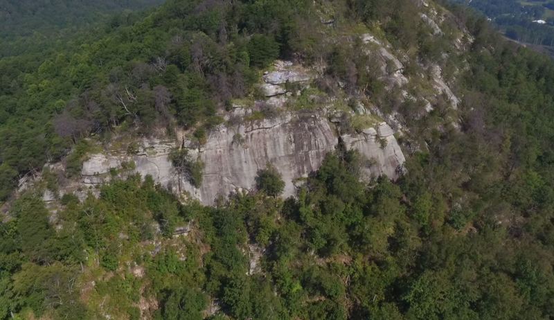
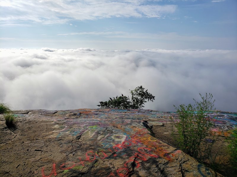
Currahee Mountain isn't an easy place to love. It's out of the way; the dirt road leading up the mountain is often in bad repair; graffiti makes parts of it look more like an abandoned urban neighborhood than a climbing area. But if you can get past all that, there is some really nice friction climbing at Currahee that makes it worth a visit. The ease of access doesn't hurt either. Some of the best lines include Mikey's Mantle, Frictionary and Pigs on the Wing.

The rock at Currahee is good quality granitic gneiss, mostly slab. Most routes are bolted to a greater or lesser degree, but some trad gear is good to have on many lines. Many routes have accessible anchors for top roping. The bouldering is scattered across the mountain, but there are some good routes if you know where to look for them.

Camping is no longer permitted along the road that ascends the mountain, but is permitted throughout the Lake Russell WMA that Currahee is on the boarder of. The town of Toccoa is nearest source for food and other non-climbing essentials. The closest place to purchase climbing gear is Wander North Georgia's Tallulah Falls location.

To help out cleaning up this place: facebook.com/curraheecleanu…

Getting There

From Atlanta, head north on I-85 to I-985 and take 985 until it ends, continuing on as US 365/441. Bear off at the Toccoa-Lavonia exit and watch for a traffic-light controlled intersection with 123. continue on 365 for approximately 6 miles, and turn right onto 184 at the traffic light, below Currahee. in 1/4 mile, turn left to stay on 184, following the road for almost 1 mile. The climber's parking lot is a small loop on the right. This is recognized as the "climbers parking lot" and utilizing this lot instead of continuing up the road can help reduce the impact of climbing on the area.

There is a yellow gate the climbers will have to pass to access the gravel trail that exit just between the brick wall and the slab wall. Up and left leads to the Brick Wall, and slightly up and right leads to the Slab Wall.

Photos [Hide ALL Photos]

Lower parking lot at Currahee off of 184. Notice the yellow gate that starts the approach. This hike takes about the same time as the drive to the top.
[Hide Photo] Lower parking lot at Currahee off of 184. Notice the yellow gate that starts the approach. This hike takes about the same time as the drive to the top.
How to get to the walls from the top parking area
[Hide Photo] How to get to the walls from the top parking area
Currahee trails
[Hide Photo] Currahee trails
Gulf Fritillary caterpillars, some of the wildlife that the plants on Currahee supports.
[Hide Photo] Gulf Fritillary caterpillars, some of the wildlife that the plants on Currahee supports.
Main face on Currahee
<br>

<br>
Credit: Southern Aerial Media
[Hide Photo] Main face on Currahee Credit: Southern Aerial Media
Slab area mikeys mantle and all I want is a pepsi
[Hide Photo] Slab area mikeys mantle and all I want is a pepsi
Boulder with the roof finger crack. Turn right here for slab wall or continue up briefly and make a left for the brick wall.
[Hide Photo] Boulder with the roof finger crack. Turn right here for slab wall or continue up briefly and make a left for the brick wall.
After the dirt and gravel road starts the single track trail into the woods. Take this trail all the way to the boulder with the roof finger crack.
[Hide Photo] After the dirt and gravel road starts the single track trail into the woods. Take this trail all the way to the boulder with the roof finger crack.
By Gully, last route in Slab Area. Shot from ledge above Buzzard Breath.
[Hide Photo] By Gully, last route in Slab Area. Shot from ledge above Buzzard Breath.
View from the top on a cloudy day.
[Hide Photo] View from the top on a cloudy day.
Currahee can be pretty too
[Hide Photo] Currahee can be pretty too
the trail leads to this view point. Its a great view, however i didn't realize there was gonna be so much spray paint, beer bottles, and other evidence of southern stereotypes.
[Hide Photo] the trail leads to this view point. Its a great view, however i didn't realize there was gonna be so much spray paint, beer bottles, and other evidence of southern stereotypes.

Comments [Hide ALL Comments]

JOhn CAmeron
Athens, GA!
[Hide Comment] Currahee is a simple place- i like it a lot. however, i am easily pleased. you get to look around at the surrounding countryside: the rolling hills and farms and the brick wall faces direct west so the sunsets are great. with easily placed topropes, its a great place to introduce people to the sport. Sep 22, 2007
[Hide Comment] Does anyone know if you can camp at the top of the mountain? I was checking out the area recently and saw a couple fire pits on the backside. I figure someone was camping there but didn't know if it was "allowed". I want to go climb there and wanted to camp but didn't know if I was going to run into any issues other than the gate closing at some point.

Thanks for your help. Nov 20, 2012
Mark O'Neal
Nicholson, GA
[Hide Comment] To access the trail to the top of Curahee. Park on Hwy 184 0.9 miles south of Dicks Hill Pkwy. There is a old polling place on the west side of the road with dual entrances and parking. There is an obvious trail built by the boy scouts that takes you to the top. Turn right at a boulder with a little mini cave to access the Slab Area and Buzzard Wall. Keep going straight another minute and then turn left to access the Brick Wall

Edit July 2013: Polling building and gates are gone. Mar 5, 2013
Tom Caldwell
Clemson, S.C.
[Hide Comment] I added some photos describing the approach from the lower parking lot. If you are a climber, this should be the way you take. The hike takes about the same amount of time as driving up the road to the top. It also saves a lot of wear and tear on your car. Look for the horseshoe shaped parking lot with the yellow gate on the right side. In years past, the road to the top often is closed due to the road being too wet. Jan 22, 2015
Luke R
Athens, GA
[Hide Comment] Not sure if it's been addressed on here or on the Currahee Clean-Up page, but I wanted to thank whoever has been doing bolting/rebolting here. Noticed some new looking bolts at the top of "By Gully" today and the rebolt and filler of the old holes looked top notch. I hope we can get/maintain some momentum here with the clean up days. I tag the Forest Service in Vandals' photos on Instagram regularly (petty/crotchety, but I kinda don't care). Maybe we might be able to improve this place some in the next few years! Aug 7, 2016
[Hide Comment] looking for someone familiar with the area to do some climbing with. My parents live in the Greenville area and I will be visiting them soon. I would love to get some climbing in while I'm there Jan 19, 2017
Zeb
Athens, GA
[Hide Comment] As of 10/31/20, I watched someone replace the old red fixed line with a blue climbing rope. As of 1/9/21 there is no rope in the gully. There were still remnants of the previous red rope which makes me think the blue rope was taken as booty vs cleaned. Nov 1, 2020
Sam Taylor
Toccoa, GA
[Hide Comment] As time goes on I have noticed impact spreading around the climbing walls at Currahee. This is not just from non-climbing users. Please keep in mind that Currahee is a unique ecosystem due to the local geology, and there are many rare and uncommon plant species on the mountain. Practice LNT, and don't step on plants or remove them from the rock face, in particular plants growing on the rock outcrops at the tops of the faces are in danger of being extirpated. This is an issue that the USFS botanist is wary of, and could result in the closure of climbing at Currahee if damage continues to persist. One such instance is that there is a rare fern (Bradley's Spleenwort) on Currahee that only grows on rock faces, so if you see a fern growing out of a crack, leave it alone. Feb 17, 2023
Hank Caylor
Livin' in the Junk!
[Hide Comment] Is this the same Curahee mountain the 101st Airborne used to run up back in WWII? Aug 15, 2023
Mark O'Neal
Nicholson, GA
[Hide Comment] Do not use the decent gully between Pepsi and the Small Wall. It's eroding badly and a hazard you don't need to overcome. Just continue down the trail to the right and contour back around to the left. You'll wind up in the same spot in the same amount of time Jan 15, 2024