Mountain Project Logo
To save paper & ink, use the [Hide] controls next to photos and comments so you only print what you need.

Davis Face

Colorado > Buena Vista

Description

Davis Face is secluded, maybe with a party on it, and that's bad luck if there is.... The classic "Center Route" goes at 5.9, and there are a couple other routes, too! This is a beautiful face that goes at roughly 500 feet and 4-6 pitches. It is a 30 minute hike in, and the rock is bomber granite.

Getting There

Head out of BV towards Bob's Rock on 371 and take the turn east (right) on 375. Follow 375 to 375A as it winds toward the base of the hill at Davis Face. Stop when you see the awesome, big granite wall above you ;)

Per Ralph Swansen: when Rd 375a ends, stay left onto Trail 373. When 373 is approaching the base of the rock, a right turn down a hill will take you to a parking lot that is the closest to the base with an established trail to the rock. There is another parking lot on the right side of 373 a little past the aforementioned turn off with a slightly longer approach. The drive from BV takes a good 30+ minutes to the base of the rock.

Rock type

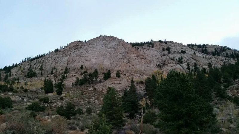
Per Tim Stich: the rock is composed of granite sediments that were fused later by regional metamorphism (metasediments). Dikes and other igneous intrusions fill in ancient cracks. It is the same type of rock as in the Badger Mountain area near Lake George. This rock often forms flakes, chickenheads, and other surface features, which can be closer in feel to sandstone than pure granite.

Routes from Left to Right

Photos [Hide ALL Photos]

Map to Davis Face.
[Hide Photo] Map to Davis Face.
Nice rack(s) below the Davis Face.
[Hide Photo] Nice rack(s) below the Davis Face.
The sketchy traverse.
[Hide Photo] The sketchy traverse.
Davis Face as seen from end of the road.
[Hide Photo] Davis Face as seen from end of the road.
The parking area for Davis Face off the main road. The J vent next to the car is for an underground aqueduct. There is a buried strand of barbed wire in the center of the road, so be aware.
[Hide Photo] The parking area for Davis Face off the main road. The J vent next to the car is for an underground aqueduct. There is a buried strand of barbed wire in the center of the road, so be aware.
Approach to Davis Face. Climber's trail to base.
[Hide Photo] Approach to Davis Face. Climber's trail to base.
Beta photo of Center Route, Unknown 5.7, & D4.
[Hide Photo] Beta photo of Center Route, Unknown 5.7, & D4.
The Davis Face as the sun sets.
[Hide Photo] The Davis Face as the sun sets.
Sport route approximately 5.9ish, just climber's right of Carter Classic.
[Hide Photo] Sport route approximately 5.9ish, just climber's right of Carter Classic.
The crux right after the first pitch.
[Hide Photo] The crux right after the first pitch.
First belay station.
[Hide Photo] First belay station.
Davis Face from the road
[Hide Photo] Davis Face from the road

Comments [Hide ALL Comments]

Dean Cool
Boulder, CO
[Hide Comment] To get to the face take 371 to 375 and follow 375 for about 2.7 miles. Turn right onto 375a. Cross over 4 mile creek and keep left on the road. This road will veer away from the creek. Stay on this road for about 5 miles and always keep left at the forks in the road. The road will pass right in front of the face. Park where you wish and hike up about 20-30 minutes to the base of Davis face. I do not believe there is an established trail so wear good shoes. 375 is a dirt road with a lot ups and downs. A 4WD vehicle is not necessary if the weather is good but you may want a high clearance vehicle for the drive. Jul 18, 2008
SAL
broomdigiddy
[Hide Comment] We put up two routes on this face back in 2001 as well. Not as clean as this listed route but worth doing if you need somthing else to do.

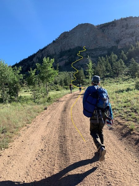
One route started down and right of the standard route under a big capped roof that can be climbed and escaped left. The line pretty much tells you where to go from there.

The line on the left was a bit more obscure, so I won't give directions on that :)

Fun face to get out, away and up. Jan 9, 2009
Jason Halladay
Los Alamos, NM
[Hide Comment] In case you're driving in at night, the last road you turn left on before reaching the parking for Davis Face is marked as 373A. If driving in during the day you can see the face so this is not an issue. Jul 5, 2009
Mike Soucy
Longmont, CO
[Hide Comment] Another route on the face starts just left of the Carter Classic and goes at .10a.
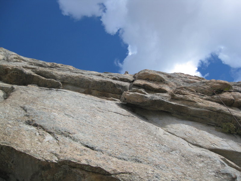
Look for a bolt 30' up or so on the slab. Follow .9 friction past bolts, supplemented with small cams to a bolted belay just left of CC.
P2 goes up and right from belay over a small roof, then following cracks to another bolted belay, .9+.
P3 trends up and right again clipping bolts along an overlap with a couple of .10a moves. An excellent pitch. Follow this to where it intersects w/ CC and finish or rap.
This is an old route that had its bolts upgraded in 2007. FA, name or original rating unknown.
Carry single set stoppers, sm/med cams, along with draws.
Several more new, high quality mixed gear routes are currently being rediscovered/developed on this wall by Ark Valley folks. Stay tuned. Jul 13, 2009
Lee Jenkins
Tucson, Arizona
[Hide Comment] Mike,

Why don't you go ahead and add the route left of CC to the route database? Just call it "unknown to the left of CC" or something like that.

Look forward to seeing more lines added to this great face! Jul 15, 2009
chad beckelhymer
Buena Vista
[Hide Comment] I don't know where there lines are at, but my dad said he put up a .10 and an .11 or maybe hard .10 in the early/mid-'90s. I can try to ask and see where they are located on the wall. It could be the .10a you are talking about for one of them, 'cause he said he put in some belay anchors.... May 8, 2014
Ralph Swansen
Boulder CO
[Hide Comment] The directions leave out that when Rd 375a ends, stay left onto Trail 373. When 373 is approaching the base of the rock, a right turn down a hill will take you to a parking lot that is the closest to the base with an established trail to the rock. There is another parking lot on the right side of 373 a little past the aforementioned turn off with a slightly longer approach. The drive from BV takes a good 30+ minutes to the base of the rock. Oct 4, 2015
Simon Kwok
Boston, MA
[Hide Comment] It's a long bumpy way in. Hope you have a car with high clearance, since we saw another car parked at the base of the climb with their under guard shield hanging, and we did a bit of damage to our vehicle as well. There's a bump just before the right turn on 273 that has a rock on it, so be careful with that. There's also a big stream puddle right after the turn. We parked just before the turn and the puddle, and it wasn't really that much further. Jun 4, 2016
Pete Krzanowsky
Evergreen, CO
[Hide Comment] As of September 24, 2016, the road to the trailhead is fine for a Subaru Outback. It seemed similar to the Turkey Rocks road.

Does anyone know what the bolted route is immediately right of Carter Classic? Hopped on it by accident. Just curious. Sep 26, 2016
D Scott Clark
Chattanooga, TN
[Hide Comment] Tried to drive my VW Passat Wagon in. Google told us to take 376 to 373, which was not passable in my extra long, low clearance, two wheel drive vehicle. My partner and I stopped before Four Mile Creek and rode mountain bikes to the trail, around 4.5 miles. 90% uphill to the trail, but it made for a fun, flowy ride back to the car after the climb. Sep 26, 2016
Chris G.
Lakewood
[Hide Comment] (As of September 24, 2016, the road to the trailhead is fine for a Subaru Outback. It seemed similar to the Turkey Rocks road.
Does anyone know what the bolted route is immediately right of Carter Classic? Hopped on it by accident. Just curious.)

- pretty sure it's unknown 5.7, I also just drove my Nissan Rogue out there with zero effort. Sep 26, 2016
Bob Smith III
Denver, CO
[Hide Comment] You NEED 2 60m ropes to rap from the summit. I thought a 70m meant I would have to downclimb the last 10 meters near the ground (5.2). I did not realize that is you rap with one 70m from the summit bolts, you would end 10 meters about the pitch 5 chains on The Carter Classic...I had to build a gear anchor, lower my partner to the chains, and then downclimb the 5.8 back to the anchors. It was not ideal.

If you have just 1 70m rope, you can climb all of the way to the top of pitch 5 on The Carter Classic, which is the end of the good climbing anyway.

Have fun! Oct 3, 2016
Nicky C
Front Range Co
[Hide Comment] I am very excited to check out the routes on The Davis Face.
Thank you for the hard work developing this area.

Are these routes, Carter Classic, D3, and D4 sport climbs in their current condition? I have heard conflicting reports if they are purely sport or mixed gear.

This is not a complaint or a suggestion... I love the beauty of the many mixed lines we have in the South Platte, but I want to make sure I don't set up this thing unprepared. Bring a rack?

Any input welcome / Thanks,
Nick Nov 16, 2016
[Hide Comment] Super easy drive with a Subaru Outback- more clearance than needed. Nov 11, 2019
Tim Stich
Colorado Springs, Colorado
[Hide Comment] At the parking area, you may notice some J shaped pipe vents coming out of the ground and a locked door in a concrete slab. This is for a subterranean aqueduct. Jul 31, 2020
Sam Shantry
Denver, CO
[Hide Comment] High clearance required and 4WD recommended for the last bit of the road to Davis Face as of 7/22/22. VW Tiguan and and Subaru Crosstrek made it to about 0.7 miles away from Davis Face parking before encountering a large rock in the middle of the road, washed out on both sides, no way to pass without bottoming on the protruding rock. Still possible to camp a little further away and hike the extra distance in if you don't have a truck or other high clearance vehicle. Even before the rock where we turned around, I had bottomed out multiple times and watched my friend lift his wheel on his Crosstrek multiple times. Jul 25, 2022