Mountain Project Logo
To save paper & ink, use the [Hide] controls next to photos and comments so you only print what you need.

Mt. Sill

California > High Sierra > 09 - Palisades & Surr…

Description

High alpine peak in the Palisades - California's most alpine mountain group. Has a commanding view of the surrounding area. Most usually accessed from the east, via North Fork of Big Pine Creek.

Getting There

The eastern approach:

From Big Pine on 395 drive up the road to Glacier Lodge, trailhead is signed on the right.

Hike up the North Fork of Big Pine Creek past Cienega Mirth, Lon Chaney's old cabin, and First, Second, and Third (spectacular views of Temple Crag) Lakes, then instead of continuing on to Fourth Lake turn south and up into Sam Mack Meadow. This is where I usually camp (6 miles, 3,400 ft of elevation gain). People staying more than a couple of days may want to cross the creek and head up the glacier trail to primitive sites either below the Palisade Glacier Moraine, or on the Moraine (1.25 miles, 1,100 more feet of gain).

Standard descent is via the North Couloir - which is non-trivial. The Northwest Face can also be descended via rappel but is not recommended.

Routes from Left to Right

5.7 5a 15 V+ 13 MVS 4b
 129
Swiss Arete
Trad, Alpine 6 pitches
4th 1 2 I 2 M 1b
 31
North Couloir
Trad, Alpine
5.2 3 8 II 8 D 2c
 1
North Couloir Variation
Trad, Alpine 3 pitches
Mod. Snow
 1
Northwest Face
Trad, Snow, Alpine 3 pitches
Route Name Location Star Rating Difficulty Date
Swiss Arete
 129
5.7 5a 15 V+ 13 MVS 4b Trad, Alpine 6 pitches
North Couloir
 31
4th 1 2 I 2 M 1b Trad, Alpine
North Couloir Variation
 1
5.2 3 8 II 8 D 2c Trad, Alpine 3 pitches
Northwest Face
 1
Mod. Snow Trad, Snow, Alpine 3 pitches

Photos [Hide ALL Photos]

Mount Sill eastern approach
[Hide Photo] Mount Sill eastern approach
Sill, North Pal, and Thunderbolt from the summit of Temple Crag.
[Hide Photo] Sill, North Pal, and Thunderbolt from the summit of Temple Crag.
Mt Sill Swis ArĂȘte .
[Hide Photo] Mt Sill Swis ArĂȘte .
Derek on Swiss Arete, route finding
[Hide Photo] Derek on Swiss Arete, route finding
The big spike that leads the way to the descent off Sill. The rappel is about 60 meters down and Skiers right from this photo!
[Hide Photo] The big spike that leads the way to the descent off Sill. The rappel is about 60 meters down and Skiers right from this photo!
Galey-Sill traverse from Temple Crag
[Hide Photo] Galey-Sill traverse from Temple Crag
Approaching the palisade glacier
[Hide Photo] Approaching the palisade glacier
Temple-Galey-Sill traverse from Temple Crag
[Hide Photo] Temple-Galey-Sill traverse from Temple Crag
Mt. Sill and polemoniums.
[Hide Photo] Mt. Sill and polemoniums.
Mt. Sill.<br>
Photo by Blitzo.
[Hide Photo] Mt. Sill. Photo by Blitzo.

Comments [Hide ALL Comments]

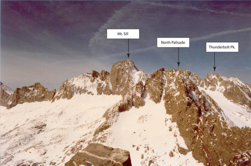
[Hide Comment] Anyone been up this year and have info on the glacier's condition? (July 2015) Jul 14, 2015
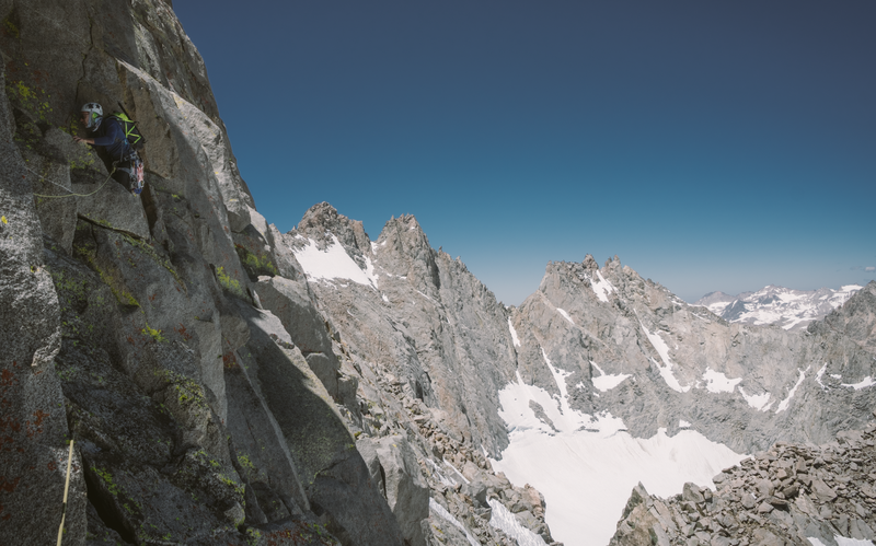
[Hide Comment] Last weekend we found that having two ropes to rappel meant we safely and comfortably got down from the notch to the ledge where we could walk casually over to the L-shaped couloir on the descent. With one rope you'd end up in the middle of some very steep snow or snow/talus combo, which didn't look fun. I'm sure you'd figure it out with one rope (or none at all!) but if you are looking to make it super safe and casual, consider climbing with double ropes for this reason. Jun 28, 2019