Colorado
> Alpine Rock
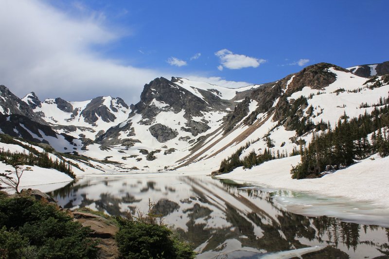
Located in the Arapaho and the Roosevelt National Forests in Colorado, the Indian Peaks Wilderness area was added to the National Wilderness Preservation System by Congress in 1978. The name was selected because many of the peaks within the wilderness are named for Native American tribes of the west. This wilderness area covers nearly 75,000 acres, following the Continental Divide south for nearly 16 miles, with the Rocky Mountain National Park as its northern border.
Indian Peaks contains vast areas of alpine tundra, numerous cirque basins with remnant glaciers, and nearly 50 lakes. Streams in the wilderness include Middle and South St. Vrain, Boulder, Buchanan, Cascade, and Arapaho Creeks. Elevations range from 8,400 to over 13,000 feet. The underlying rock of the Indian Peaks area is 80-90% Precambrian biotite gneiss formed approximately 1800 million years ago. The area has since been reshaped by at least six glacial sequences dating back 15,000 years.
Within Indian Peaks lie
N Arapahoe Peak (13,502 ft),
Apache Peak (13,438 ft.),
Navajo Peak (13,405 ft*.),
S. Arapahoe Peak (13,397),
Ogalalla Peak (13,333 ft.),
Mt. Audubon (13,233 ft.), Parry Peak (13,391 ft.),
James Peak (13,294 ft.), Arikaree Peak (13,146 ft.), Paiute Peak (13,083 ft.),
Mt. Toll (12,979 ft.), Shoshoni Peak (12,962 ft.),
"Ooh La La!" (12,945 ft.), Pawnee Peak (12,939 ft.),
Jasper Peak (12,923 ft.),
Elk Tooth (12,848 ft.),
Mt. Neva (12,814 ft.,),
Hiamovi Tower (12,220 ft.),
Lone Eagle Peak (11,940 ft.), and Niwot Ridge. There are four trail passes:
Devil's Thumb (11,747 ft.), Arapahoe (11,906 ft.), Pawnee (12,541 ft.), and Buchanan (11,837 ft.).
Be prepared for changing weather, wind, and watch for sudden onset of thunderstorms and lightning.
Note, some areas within the Indian Peaks Wilderness area are closed to the public and trespassing can result in hefty fines.
Please refer to the individual mountain and route descriptions as different trailheads are often used.
If you plan to stay overnight, a permit from the U.S. Forest Service is required between June 1 and September 15. Camping regulations will be given to you when you apply.
Permits may be obtained from the USFS District Office at 2995 Baseline Road, Boulder, Colorado 80303 (111 6600), or at the Sulphur Ranger District, US Forest Service, 62429 US Highway 40, Granby, CO 80446."Last Chance" permits are available at Coast to Coast Hardware in Nederland, Colorado.


 Continue with onX Maps
 Continue with Facebook


Reno, NV
Westminster, Colorado
boulder, co