San Rafael Swell
Utah
> S Central Utah
Description
The San Rafael Swell is a huge area in the center of Utah, with few people and fewer services. It is the area roughly bordered by Price in the north, Green River to the east, Capitol Reef to the south, and the mountains to the west. I-70 divides the swell into two parts, and is the only paved road within the swell. US 6, Utah highways 10 and 24, and the Moore cutoff road travel around the edges of the swell, and there are many dirt roads - some are good, some are very bad, and all can be difficult to travel during big storms.
The climbing in the swell is tremendously varied, and lies on the adventurous end of the spectrum. Buckhorn Wash is the most popular area, and hosts a high concentration of excellent Wingate crack climbing, as well as towers and bouldering. The San Rafael Reef, AKA the Sandstone Alps, have extremely long slab routes on mostly good rock with very significant runouts. Other areas are less popular, but the climbing is very good for those who are interested in exploring.
Eric Bjornstad's Desert Rock II is the main printed guide to the swell, but it is out of print and only has a small percentage of the routes that have been done. Cam Burns Selected Climbs of the Desert Southwest has a few routes, as does the Falcon Rock Climbing Utah guidebook. New routes are going in constantly, and at this point mountainproject supplemented by Desert Rock II is the best source of information, though it is far from complete.
In addition to rock climbing, the San Rafael Swell is home to impressive rock art, many slot canyons, mountain biking, mellow flatwater canoe trips, class III slot canyon duckie floats, and wild class V kayaking. Crowds are minimal compared to the Moab area, though so are any kind of developed services.
There are no towns or services in the San Rafael Swell aside from a rest area on I70 and a few outhouses along the Buckhorn Wash Road. The closest places for food or gas are Green River, Price, Castledale, Hanksville, or Salina depending on where in the swell you are. Cell phones get no reception except for a few spots along I-70. There is great camping pretty much everywhere in the swell, but bring all of your food, water, and firewood.
The swell is all BLM land, and has little regulation aside from the wilderness study areas. The downside to this is that the area gets trashed sometimes, especially by OHVers who visit the area in large numbers. Practice leave no trace, clean up after others as much as you can, and consider using wag bags if you can't make it to one of the outhouses.
Getting There
This is a vast area in the center of Utah split by I-70. The most popular areas are accessed by the Buckhorn Wash Road. Most of the main roads in this area are good dirt roads, and you can usually at least get close in a 2WD. The road conditions can change quickly since they don't see much traffic, and the remote parts of the swell are not a good place to have car trouble. Visitors should always come to the swell with a full tank of gas, a spare tire in good condition, and extra food and water just in case.
![The Hollow Men ..A climb out of Three Finger Canyon.Eastern Reef Slab area.]()
[Hide Photo] The Hollow Men ..A climb out of Three Finger Canyon.Eastern Reef Slab area.
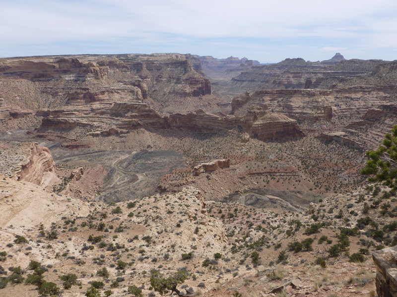
![Little Grand Canyon Overlook]()
[Hide Photo] Little Grand Canyon Overlook
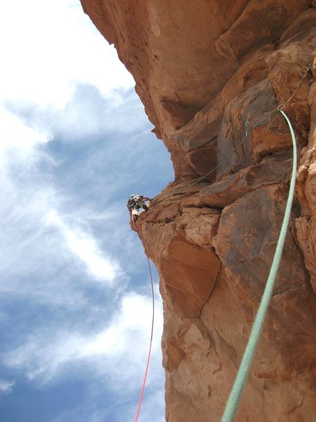
![Preparing for battle on "Private Pizza"]()
[Hide Photo] Preparing for battle on "Private Pizza"
![On the Eastern Reef 800' + climbs of all grades ... Over 200 climbs Photo Steve Rydalch on FA of Curiosity killed the Cat]()
[Hide Photo] On the Eastern Reef 800' + climbs of all grades ... Over 200 climbs Photo Steve Rydalch on FA of Curiosity killed the Cat
![Looking down the southern end of the Eastern Reef Slabs.The large slab in the foreground is the Surfing the Swell section over 1600'in height.]()
[Hide Photo] Looking down the southern end of the Eastern Reef Slabs.The large slab in the foreground is the Surfing the Swell section over 1600'in height.
![It took her all day to carve these]()
[Hide Photo] It took her all day to carve these


 Continue with onX Maps
 Continue with Facebook


Evergreen, CO
SMOGden, UT
Salt Lake City, UT
Guidebooks are a tough proposition for the swell since new routes are going in constantly, it is a huge spread out area, and lots of the climbers there are crusty folks who don't like to share or have never heard of the internet. Mar 5, 2013
Logan, UT
sltrib.com/sltrib/news/5675… Aug 22, 2013
Basalt, Colorado
Salt Lake City, UT
If you don't mind driving more like 25-30 minutes, go to the Buckhorn Wash. There is some excellent bouldering along the Mexican Mountain road, especially around the mouth of Red Canyon.
If you are looking for camping pretty much by the exit, the Copper Globe Mine road area is good. No rock very near the freeway there though. Nov 7, 2013
Salt Lake City, UT
You'll have to carry all of your own water just about everywhere in the desert - its really better suited to day trips for the most part. That said, hiking the San Rafael River between Fuller Bottom and the San Rafael Bridge is nice, and you can also hike up into Cane Wash, which is really great. I wouldn't be keen on trying to get water out of the San Rafael since it is silty and winds through a lot of cow pasture.
You could hike up both branches of Red Canyon off of Mexican Mountain road.
Eagle Canyon would be a great option. Go to Swasey's Cabin, drive down the road as far as you are comfortable, and start hiking. Sep 19, 2014
Keswick, Cumbria
Boulder, CO
Salt Lake City, UT
Anchor replacement and continued access for climbing should be included in the plan. There is a virtual option for the March 7 meeting. Let's advocate for climbing, and route maintenance as acceptable uses of the Federal Recreation Area. Mar 5, 2024