To save paper & ink, use the [Hide] controls next to photos and comments
so you only print what you need.
Wigwam Creek/Lost Creek Wilderness
Colorado
> S Platte
Description
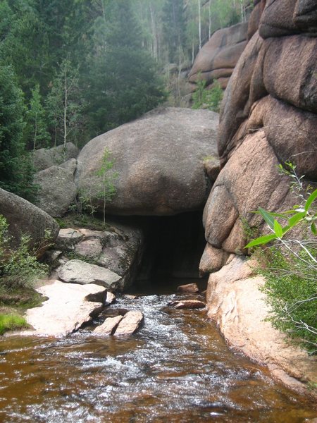
The Lost Creek Wilderness area is a superb destination for climbing huge domes, buttresses and a few towers made of Pike's Peak granite. Essentially an extension of the South Platte area, Lost Creek Wilderness offers over 100 square miles of rugged wilderness and a lifetime supply of climbing opportunities. Goose Creek is the most popular area with backpackers as well as the namesake of this wilderness. It disapears and reappears no less than seven times on its course to the South Platte and is rumored to be the home of North America's biggest boulder cave. Although the area does receive heavy usage from front range weekend warriors, climbers will have no problems with crowds. With most approaches measured in miles and not minutes, Lost Creek is best suited for multi-day trips. The routes are typical of the South Platte, multi-pitch cracks and friction climbs mostly on big domes. I would recommend tape if you are climbing cracks out here. Two ropes is also a good idea. The camping is fantastic! Great fishing in Goose Creek and tons of wild raspberries in the fall. A few things to remember: 1. This is a wilderness area so leave power drills at home 2. The whole South Platte area is very dry so use extreme caution with camp fires 3. This is a popular area with pond scum that like to break into cars at trailheads so leave your CD collection and radar detector at home (if your fortunate enough to own those things) 4. Lots of fixed gear is very old and unreliable so use good judgement before trusting your life to rusty old button head bolts. This is an amazing part of Colorado so treat it with respect and be a wise wilderness user. ..............................................
Getting There
This is a huge area with many different trailheads. Generally Lost Creek Wilderness is south of Hwy 285 and west of Hwy 126. The most popular trailheads are reached by turning off Hwy 126 three miles west of Deckers onto FR 211. At this point a good map comes in handy in locating exact trailheads for the different areas of Lost Creek Wilderness. Specific directions will also be found on this site under the "Rock" section. ..............................................................
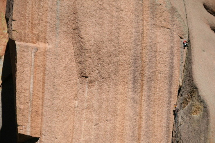
[Hide Photo] Hmm! Fresh meat!, 5.10 Tom Carr approaches the crux transition. He is passing the only protection bolt on the route. We all thought having three #6 camalots for pitch three would be best.…
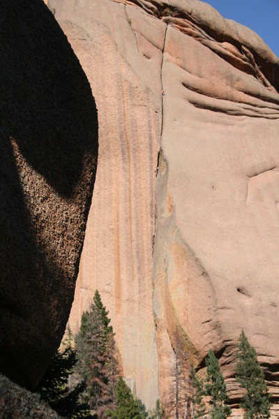
[Hide Photo] Wigwam Tower, Keystone Buttress and September colors in the Lost Creek.
[Hide Photo] Hmm! Fresh meat!, 5.10a, Lost Creek Photo my Mike Carr. July 15, 2009 FA Crusher Bartlett and Strappo Huges, 1991 (all dates approximate) In this photo, Tom Carr is belaying KT up pit…
[Hide Comment] I assume this is all burned up thanks to our firiends at the National Forest Services. Good job with the background checks guys!!!!
Jun 25, 2002
[Hide Comment] If don't be a jerk is the only guideline, why did you allow a comment like, "I assume this is all burned up thanks to our firiends at the National Forest Services. Good job with the background checks guys!!!!". A lot of good people worked hard on this fire to keep it down to the size it was. Maybe it was a FS employee who started it, but that doesn't make everyone in the Forest Service incompetents and criminals. Furthermore, I doubt any background check would have made any difference. As it stands, the Hayman Fire burned only about 6,000 acres in Lost Creek, none of it in the established climbing areas and little in areas with any climbing potential. The hotshot crews who were in there deserve some thanks for the days of hard work they did with minimal impact on the Wilderness.
Sep 30, 2002
[Hide Comment] I have been back there a bunch. A good trailhead to use is the FS Lost Park camp ground. This is found by heading south out of Denver on 285. Turn left on Lost Park RD just south of Kanosha Pass. If you're into adventure climbing, this is a sick place. Unlimited opportunities. There is a tower back there with an offwidth splitter that you can't take your eyes off. I believe it has been climbed, I'm not sure by who, but at 5.12. It really is an amazing place. I hope not too much of it was destroyed.
Oct 17, 2002
[Hide Comment] ABSOLUTELY BEAUTIFUL area to climb in. Hard stuff as well as the easier beautiful McCurdy Park Tower are all still intact after the fire. It got close, but I've been up there and its still gorgeous, except the storms almost every day, do NOT plan on climbing after 1:00!!! I could set my watch on my six day trip.
For climbing, you're pretty much on your own, very difficult to find beta.McCurdy Park Tower (on the right as you walk into McCurdy Park labeled on maps) is an excellent place to take begineers on 3 pitch trad. It is very forgiving, HEAPS of places to put pro and on most routes if you feel nervous about a spot, take two steps to the side and you'll be on 5.easy, and you'll never have to worry about it being to crowded. (I had to repell to escape a storm, came back a year later and found the same gear (couple stoppers and runners) sitting right where I left 'em :) )
Dec 4, 2002
[Hide Comment] The latest issue of Climbing magazine (No 218, Feb 1 2003) has some useful information regarding the present state of this area and the effects of the Hayman fire. It looks like some of this area could possibly re-open as soon as the January 15 2003!! As for the Wigwam Creek area, according to the article, unfortunately things don't sound good.
[Hide Comment] I was back up in the Wigwam Creek area today and I am happy to report that the majority of this valley was spared from the Hayman fire. Wigwam Dome was untouched and I think it is safe to say the same for Wigwam Tower. However, Rock Island, Bush League Buttress and Bear Tooth Rock did not fair as well. The hillsides surrounding these were torched.
Sorry for adding to the Hayman Hysteria. I don't know if we should thanks fire fighting crews or Mother Nature for leaving this area largely uneffected, but I for one am over joyed to still have these gems as a viable and beautiful climbing destination.
Jun 13, 2003
[Hide Comment] AC - Not sure about the Tower per se, however, several years ago we put up a two pitch sport route on Eagle Rock, and this had great stone on it. Overall, the climbing at Eagle seemed limited due to the blocky nature of a lot of the stone. Nonetheless, one could find numerous moderate trad lines here. South from Tarryall reservoir, along road 77, one encounters a huge amount of largely untouched stone with much of this being quite large. I would imagine that most of this stone is typical South Platte. In my searches through old magazines and guides, I've not found much that has been recorded from here. Perhaps some of the really old farts might know of unrecorded climbs in this sector. Regardless, the potential is huge and the rock likely excellent. All it needs is the adventurous with a tolerance for hiking.
Jul 14, 2003
[Hide Comment] For sure, and too bad at that. Eagle Rock is well outside of the Wilderness boundary. However, a hike into the Wilderness from the North, revealed loads of rock up there as well. Hmmm.... oh well.
Jul 24, 2003
[Hide Comment] Rest assured my friends Lost Creek did not burn. We did a 23 mile loop on the south end and were blown away by the massive domes. Still searching for beta of the area but can't find anything. I am assuming its untouched by climbers but someone has to have scaled the incredible granite.
Aug 24, 2004
[Hide Comment] I climb in the Tarryalls and Lost Creek areas a lot, and Pete is certainly right. There is an amazing amount of quality stone and a handful of geezers, old farts and even a few young farts occasionally cranking up them.
The area is wild, long approaches are typical, information is scant, fixed pro is rare.... and thats exactly what makes the place so special. Past climbers have made a special effort, I believe, to maintain the wild character of the Tarryalls and Lost Creek Wilderness.
It is truly one of the last great places in Colorado for wilderness-style climbing. Sure the route you climb may have already been done, but chances are there will be no sign of a previous ascent. With any luck, it will be this way indefinitely. It's just you, your partner, and the rock (Good rock, too!)
If this type of climbing appeals to you, and if you don't mind long hikes and self-reliance, then you will enjoy climbing here and you should come check it out. While you're here, you may come across some other wierdo scoping routes up one of the unnamed domes or spires ...but not likely.
[Hide Comment] If you are headed back too keystone buttress or wigwam tower you might as well not even look at the topo or read the directions in Hubbel's book. To clarify, it is 6-8 miles to the base of these rocks and you take a left across the creek instead of a right as the topo shows. But from the point where the trail splits you can easily see these magnificent towers. I would love to spend a week back there exploring so it's definitely worth the hike if you got the time. This is probably some of the most magnificent and remote climbing the splatte has to offer!
Nov 22, 2004
[Hide Comment] The Hayman Fire did burn alittle of the Lost Creek area but the majority of the damage was done by the Topaz and Buffalo Creek fires that started off the year of the Hi Meadow Fire, and if anyone was curious the Tarryall Range has seen a signifigant amount of unpublished climbing, there are a few locals up there putting up lines and a ton of boulder problems.
Jun 22, 2005


 Continue with onX Maps
 Continue with Facebook


![[[105745864]] and Keystone Buttress.](https://mountainproject.com/assets/photos/climb/106891240_medium_1494148834.jpg?cache=1701316523)


Portland, OR
South Ogden
For climbing, you're pretty much on your own, very difficult to find beta.McCurdy Park Tower (on the right as you walk into McCurdy Park labeled on maps) is an excellent place to take begineers on 3 pitch trad. It is very forgiving, HEAPS of places to put pro and on most routes if you feel nervous about a spot, take two steps to the side and you'll be on 5.easy, and you'll never have to worry about it being to crowded. (I had to repell to escape a storm, came back a year later and found the same gear (couple stoppers and runners) sitting right where I left 'em :) ) Dec 4, 2002
Jan 8, 2003
Sorry for adding to the Hayman Hysteria. I don't know if we should thanks fire fighting crews or Mother Nature for leaving this area largely uneffected, but I for one am over joyed to still have these gems as a viable and beautiful climbing destination. Jun 13, 2003
Lakewood, CO
Lakewood, CO
The area is wild, long approaches are typical, information is scant, fixed pro is rare.... and thats exactly what makes the place so special. Past climbers have made a special effort, I believe, to maintain the wild character of the Tarryalls and Lost Creek Wilderness.
It is truly one of the last great places in Colorado for wilderness-style climbing. Sure the route you climb may have already been done, but chances are there will be no sign of a previous ascent. With any luck, it will be this way indefinitely. It's just you, your partner, and the rock (Good rock, too!)
If this type of climbing appeals to you, and if you don't mind long hikes and self-reliance, then you will enjoy climbing here and you should come check it out. While you're here, you may come across some other wierdo scoping routes up one of the unnamed domes or spires ...but not likely.
Mark BeardsleyFairplay Sep 1, 2004