Mountain Project Logo
To save paper & ink, use the [Hide] controls next to photos and comments so you only print what you need.

North Table Mountain/Golden Cliffs

Colorado > Golden
Warning Access Issue: Please Obey Speed Limits & Rim Rock Trail Closure DetailsDrop down

Description

Sitting above Golden, this popular cliff band faces south & west, so it makes for comfortable winter/cold weather rock climbing. Per Tim Stich: the rock was formed by shoshonite porphyry lava flows, making it unique in character to most other crags in the area. Most routes here are tightly bolted and generally short (60 foot range), so a 50m rope and 10 quickdraws will often be sufficient. Toproping many routes is easy to do, with quick access to the top and bolts just below the top anchors just below the top of the cliffs; however, the rock at the top can be loose in places, so make sure you're safe when setting up topropes.

IMPORTANT: please drive slowly (speed limit is 20mph) through the neighborhood along Peery Parkway. Over many decades, the main point of friction with local residents has been drivers speeding on their way in or out of the park. As of 2023, this is still an active problem that the Golden Police Department is addressing through increased enforcement. Let's do our part to make the neighbors glad that they live near public open space and such a popular climbing area.

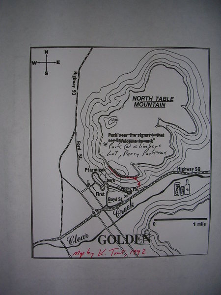
There are two parking lots, but the lower one (right fork) has the bathroom, trash cans, and trailhead sign and should be used first (the upper lot is technically an overflow lot only). From both the upper and lower parking lots, follow the main trail up to the cliffs. Beware of rattlesnakes in the summer and fall. The trail meets the cliff, you are on the far right (east) side of the cliffs.

The Golden Cliffs see a lot of use, and some anchors are being severely worn by people running topropes directly through anchors. If you plan to toprope, please preserve the resources by using quickdraws or carabiners on the anchors, and whenever possible rappel off rather than lowering through the anchors.

Note, as the years have gone by and the popularity of this area has increased, the rock has become polished in places...amazingly so in spots. In particular, warm days can make the rock feel greasy and leave the infrequent visitor feeling sandbagged at times. Beware.

Climbing has been part of North Table Mountain since the 1950s, and the cliffs were preserved through an amazing collaboration between the former landowner Mayford Peery, the Access Fund (to whom Mr. Peery gave his property in 1997), the City of Golden, and Jefferson County Open Space (JCOS). The area straddles land owned by Golden and Jefferson County Open Space, though today, JCOS owns and manages the cliffs and most of North Table Mountain proper (including the lower parking lot and the official trailhead), while the city of Golden owns the upper parking lot and the slopes below the cliffs.

The entire North Table Mountain park sees very high traffic from users of all kinds-- climbers, bikers, hikers, etc.-- so please help preserve this place by staying on trail, packing out all your trash and dog/human waste, and respecting the folks who live nearby.

There is a dumpster here; however, consider recycling your cans and bottles rather than filling landfills.

Organization

There are 4 access points for these crags - the North Table Mountain Park parking lot along CO 93, the Access Fund lots on Peery Parkway, the on ramp area onto CO 58 from Easley Road, and the "blue house" trailhead along Ulysses Way/W 43rd Drive.

On top of the mesa (usually access from the CO 93 lot):

Sea Cliffs of North Quarry
Crater Crag of North Quarry- which is just opposite North Quarry / Pinnacle Area

The sections of crags below the top here L->R:

A. North Quarry / Pinnacle Area
B. The Risk Area
C. Winterfest Wall
D. The Hot Spot Area
E. Winter Warmer Area
F. Twelve Pack Wall
G. Industrial Buttress
H. MBA Buttress
I. Trad Lands
J. Table Top Area
K. Overhang Area
L. Brown Cloud Rocks
M. Child Free Zone (buttresses above & below) - trail comes up below this area.

These areas utilize different parking either off Easley Rd. or Ulysses Way:
N. The Quarry Wall
O. The East Quarry
P. EMF Wall

Getting There

For the bulk of North Table: from the east, take I-70 west to CO Hwy 58. Get off at Boyd St. Go to the 2nd stop sign. Go straight/uphill on Plateau following it briefly as it curves right. Go left and then take the first right onto Peery Pkwy. The sign says "Dead End". Go to the end of the street, continue past the gate. There are 2 lots - the "overflow" to the left and the main lot (with the pit toilet). Please, pay attention, and drive respectfully and obey the speed limit as you are driving through neighborhoods.

From the north, take CO Hwy 93 south to Golden. Just as you enter town, take a left on Washington St. Follow Washington to 1st Street, and take another left. Once across the bridge at the bottom of the hill, take a right on Partridge Cr. Turn left (east) on Ptarmigan St. Ptarmigan St. which will turn into Peery Pkwy.

From the west, take US 6 on to CO 58. Exit Washington St and go south to 7th Ave. Go east to Ford St. Go east (just after crossing under CO 58) on 7th Pl. Go north (left) onto Boyd St. Follow this as it goes uphill and curves right and becomes Plateau Pkwy. Take a left and go uphill on to Peery Pkwy to its end as it also curves right (east).

For the above, follow Perry onto a dirt road that will lead to one of two parking lots. The lower lot has the outhouses. Both lots have trails which head uphill. For reference, the new Access Fund trail comes up to the main cliff just below This Ain't Naturita, Pilgrim in the Overhang Area.

The old parking lot from the '90s has been converted into a home & garden.

For the Crater Crag/North Quarry of North Table and possible the left end of the main cliffs: from the intersection of US 6/CO 58/CO 93, head north. On the right, past Pine Ridge Rd. / Wyoming Cir. will be the North Table Mountain Park parking lot. Head up the gravel road.

For the East Quarry, Quarry Wall, and East Bluffs of East Quarry: see the suareas for directions that utilize the MacIntyre exit off CO 58 and Easley Rd.

Access Issues

Per Brett Brotherton: I attended a meeting last night with JCOS, City of Golden, and Golden PD. Residents on Peery Pkwy. have observed many trailhead users driving too fast.

Please be courteous and respectful when driving through neighborhoods by paying attention and following posted speed limits. At the trailhead, be sure to clean up trash, and stay on trail so as not to jeopardize access. Let's show that the climbing community is doing its part to reduce impact on those living nearby.

Fauna

Note, there are rattlesnakes here. Occasionally, folks wind up in the ER or ICU ($$$) with envenomations. Watch your dog, too. Use caution!

Dogs

Dogs are required to be on leash at all times as per regulations of both the City of Golden and JeffCo Open Space. These regulations apply (separately) to all portions of the Golden Cliffs / North Table Mountain Park.

Photos [Hide ALL Photos]

A solo on an unknown piece of rock.
[Hide Photo] A solo on an unknown piece of rock.
Climber Memorial, Craig Luebben, North Table Mountain.
[Hide Photo] Climber Memorial, Craig Luebben, North Table Mountain.
North Table Mountain area locations.
[Hide Photo] North Table Mountain area locations.
Inside the chalk circle, there is an old bolt from a route that fell down during a wet spring.  Same spring that Rifle's Vitamin H came down.
[Hide Photo] Inside the chalk circle, there is an old bolt from a route that fell down during a wet spring. Same spring that Rifle's Vitamin H came down.
Climber Memorial, Craig Luebben, North Table Mountain.
[Hide Photo] Climber Memorial, Craig Luebben, North Table Mountain.
Snow over Golden Cliffs.
[Hide Photo] Snow over Golden Cliffs.
PLEASE DO NOT BUILD CAIRINS ABOVE THE CLIMBS!  Buy a guidebook or an online map to guide you to your favorite routes, this is so dangerous! I took down several of these that were placed strategically over the more popular routes.
[Hide Photo] PLEASE DO NOT BUILD CAIRINS ABOVE THE CLIMBS! Buy a guidebook or an online map to guide you to your favorite routes, this is so dangerous! I took down several of these that were placed strategical…
An old map I made in 1992.  Red line shows where the climber's trail goes now.  This map was part of an article in Rock & Ice, 1992.  I also added my topo's for Brown Cloud Crags, Overhang Area, Industrial Buttress, and Winter Warmer.  Except for the new routes at Winter Warmer, no attempt was made to add all the routes that have gone in since '92.  I thought the locator insets might be of use to others since all the books are out of print.
[Hide Photo] An old map I made in 1992. Red line shows where the climber's trail goes now. This map was part of an article in Rock & Ice, 1992. I also added my topo's for Brown Cloud Crags, Overhang Area, In…
Approach trails are for suckers!
[Hide Photo] Approach trails are for suckers!
Bombs away.
[Hide Photo] Bombs away.
New hooks on Leaning Pillar@Winterfest.
[Hide Photo] New hooks on Leaning Pillar@Winterfest.
A little taste of the circus that is Golden Cliffs.
[Hide Photo] A little taste of the circus that is Golden Cliffs.

Comments [Hide ALL Comments]

Tim Stich
Colorado Springs, Colorado
[Hide Comment] Heavy rains in mid July brought a scourge of biting flies to N. Table, which made for some miserable belaying when the winds died down. Bird shit deposits on ledges are also a hazard, as they can be quite deep in places. Look before you grab. Aug 2, 2001
Guy H.
Fort Collins CO
[Hide Comment] If the Winter Warmer area is closed for the birds, like the Access Fund webpage says, someone should put a sign up there about the closure. Feb 17, 2003
[Hide Comment] The bird closure means that only chickens can climb at Table Mountain. It is climbing-lite. Hardmen will be ticketed for such silliness. Feb 17, 2003
[Hide Comment] What is the name of the little crag below the Brown Cloud Rocks? It's the first climbable thing you pass on the trail, about forty or fifty feet below the main section of cliff. There are several new routes there, as well as a large roof route that looks to be a few years old. I climbed five of the routes there yesterday (including a really fun squeeze chimney) and had a great time. I'd like to know the names of the routes, and also the story on the big, sharp block that's sticking out of the ground. It's pretty obvious it broke off from the route right above where it lies...I just wonder if it broke off when someone tried to yard on it! Jan 18, 2004
[Hide Comment] I think you are asking about the Child Free Zone with routes ranging from 5.9 to 5.12. Click on CFZ and you'll get route info and the story on the spike stuck in the dirt. Jan 19, 2004
[Hide Comment] Here's an idea for all of you who take your dogs up there... it's cool to bring your dog, but for god's sake when they take a crap next to the crags pick it up in a baggie and carry it out. In case you didn't know, this is actually a common courtesy that you should adopt when you take your dog to any public place where lots of people hang out. Hate to be negative on this site, but it's getting ripe up there.You can hardly smell the hops anymore. Jun 10, 2004
[Hide Comment] Climbed up at Golden Cliffs for my third time tonight. Great last minute, late afternoon crag with lots of fun clip ups. I have used climbing guides all over the globe and I don't mean to come of like a jerk, as I know first hand how hard it is to compile a quality crag guide. Lots of hard work researching, sending, describing, photographing, publishing, funding, etc. Although, if you are considering purchasing the Falcon guide to Golden Cliffs, think again and save your cash... Absolutely worthless! Myself and four other groups at the cliff that had climbed there much more than myself shared the popular opinion that this guide was useless. The two other times I was there I watched people staring at the cliffs stumble back and fourth with this guide wondering where they were. Out of fairness to the guide and it's contributers who I respect and apreciate their efforts to the fullest, it was compiled in 1997 and many new routes have been added. But there are no route descriptions, just names and grades. This leaves a book full of pictures of various frames of rock that all look the same with no written descriptions for a user to gain a bearing and decipher one route from the next. Aug 23, 2004
[Hide Comment] Poor guides is another unfortunate drawback to grid bolted cliffs. It is difficult to distinguish independent lines when bolts are lees than 5 ft apart. My advice, start climbing up any route, if it gets too hard, move 6-12 inches either direction and continue clipping. Aug 24, 2004
[Hide Comment] The first time I came to this area, I thought it was the biggest pile of crap I'd ever touch.

But as I go back & back again, this place grows on me. It's unique featured vertical faces & sculptured holds makes this an area worth practicing various grades to apply to trad lines. Overall, a good place to kick back & work on better climbing moves. Mar 1, 2006
Jim Gloeckler
Denver, Colo.
[Hide Comment] There is a bad anchor at the top of Chunky Monkey. We marked the bottom with an X and the words bad anchor. Hope this helps! Nov 7, 2006
Dale D
Boulder, CO
[Hide Comment] Anyone know what the bolted route is to the right of Pack O Bob's. A low crux (5.8ish) at the second bolt to gain a short slab and then a fun jug haul. There are two blocks sitting on the ledge at the top where the anchor is. I would like to add the route to the database.

Grade?

Name?

Thank you,

Dale Sep 11, 2007
Laura Pyle
Evergreen, CO
[Hide Comment] There is a short bolted route (3 bolts plus anchors) to the right of (as you face the rock) and around the corner from Table Manners. It's a shallow crack that looks good but is not as good as I would have liked. Does anyone know what this is?

Thanks,
Laura Oct 16, 2007
YDPL8S
Santa Monica, Ca.
[Hide Comment] Is it Bad Manners you're asking about, or maybe Dan's line? Oct 16, 2007
Matt Richardson
Longmont, CO
[Hide Comment] It's been probably four years since the first time I went to this crag - about the same time that Christian put up his note - and I have to agree that the Hubbel and Schovajsa Flacon guide to the place is one of the most worthless guides I have purchased. I don't go up there much, but each time I do I spend the first 20 minutes trying to figure out where the hell I am. Adding to the absurdity of the situation is that almost everyone I pass seems to be alternately staring at the guide and the rock with the same puzzled expression that I have. And even though the cliff is grid bolted, I still think that you can put together a reasonable guide (this isn't the only area that is).

It must be the way these guys think, but it seems totally backwards, the photos are totally ambiguous (they all seem to look the same and seem massively underexposed) and (as Christian pointed out) there are absolutely no route descriptions. This guide is not worth the paper it is printed on and I hope that someone is putting together a new one (maybe with some color - or at least better photos)...until then, I will probably continue to wander around, looking for someone who knows the area better than me... Nov 10, 2007
Ken Trout
Golden, CO
[Hide Comment] My wife and I just installed about $300 worth of winch hooks and quick links on anchors up at Golden Cliffs, just like the hardware found on every route in the Owens River Gorge. Go ahead and just clip in to lower and top rope. Wear is not really an issue. Most hooks came from Golden's Home Depot, so they will be easy to replace. The introduction page for Overhang Area has more details and a picture. Dec 21, 2007
Ben Schneider
Westminster, CO
[Hide Comment] I have just finished the manuscript for a new Golden Cliffs guidebook! Expect to see this comprehensive, full color photography guidebook in shops early this fall. I've climbed 100% of the routes there in an effort to make the book as accurate as possible. However, I'm still looking for FA info that hasn't already been posted here. Also, if you've got any great action photos you think might be a good addition to the book, send 'em my way. Let me know if you have any questions or inquiries. Mar 30, 2008
[Hide Comment] Thank you Ken and Marsha for your endless effort at making the Cliffs a fun and convenient place to climb!! Apr 2, 2008
Ben Schneider
Westminster, CO
[Hide Comment] The new Table guidebook will be available as of Friday, November 28th! "North Table Mountain: Rock Climbs at the Golden Cliffs." It should be available for purchase Friday morning at Neptune Mountaineering (Boulder) and Wilderness Exchange (Denver). Bent Gate will also be selling it, but they won't have if for sale until Friday afternoon or Sunday at the earliest. This is our first book for our new publishing company (Fixed Pin Publishing - fixedpin.com) so please let me know what you think! We're super excited and think everyone will love the new book. Here's a few of the highlights: 100% comprehensive sport and trad, the new "South Quarry" area is included, 100% color description photographs, 10% of the profits will be donated to the Access Fund (the property owners) and an innovative navigation banner to help you figure out where the heck you are. Also, we chose to try to start our business with environmentally and socially responsibly printing practices, choosing to print domestically via sustainable printing and harvesting practices. See the inside cover of the book for more details.... Nov 27, 2008
M Lindfors
Highlands Ranch
[Hide Comment] Killer guidebook, Ben! Mar 15, 2009
[Hide Comment] As of September 10, 2010, I just released a new guidebook titled "Golden Rock Climbs" to North Table Mountain that retails for $20.00. It includes the popular Golden Cliffs and all the new routes in the four quarries. This quarry route information to the Sea Cliffs, Crater Crag, East Quarry plus sport routes at South Quarry is avialble in no other guidebook. The guide also has the only available information to the sport climbs of Golden Gate State Park near Dude's Fishing Hole.

This guide has a color cover 144 pages with 46 black & white photos, topo drawing and maps.

As for the Golden Cliffs the book goes from right to left. Starting with the first cliff you come to on the approach trail being the Child Free Zone and ending at the Risk Area. This is the opposite from Ben Schneider & Jason Haas's guide to goes from the north and work south and east (backwards). I think this is very useful. Also the map of the area is much improved. The approach information to the South Quarry and Pinnacle Area shows a better trail or boadbed. Even if you have the beautiful color guide, I think my guide will prove very useful with year round climbing possibilities near Golden. Oct 1, 2010
Kiul
Wheat Ridge
[Hide Comment] HELMETS! Was at Brown Cloud on Tuesday and saw a softball-sized rock come from where nobody was climbing. It landed about twenty feet away from my belayer. At the parking lot, I was informed by a girl that she saw a dude huck the rock off the top. She claimed to have yelled at him. Remember, not all hikers know that we are climbing down there. cheers Mar 3, 2011
[Hide Comment] WTF, will the morons with the MAGIC MARKS leave them at home. There is a good guidebook, we do not need the routes grade and # on the cliff in magic marker, Graffiti. Mar 11, 2011
Keith H. North
Englewood, CO
[Hide Comment] PLEASE PLEASE PLEASE!!!

Whoever is marking the bottom of the climbs, this is not acceptable outside, that stays at the gym. This crag is so commonly used to bring beginners into our sport, it would be good if it could show a better example. When I was leaving the crag today, I saw a banana peel left on the ground and a used chalk ball.... Guys, please, can we make it seem that we're a little more mature?

Other note: Anyone got any ideas on how to get the markings off the wall? My first thought was power washer, but that seems a little impractical :). Mar 20, 2011
Tony B
Around Boulder, CO
[Hide Comment] By the comment above, I'd take it that it is magic marker?
In that case, rubbing alcohol and some cloth will probably do the trick.
If I climbed there, I'd take care of it myself, but I don't. Mar 21, 2011
Eckhard Koehler
Denver, CO
[Hide Comment] Sadly, the "marker" looks a bit more like a paint pen. Having not been to the cliffs in 2 years, it was a shame to see some MORON'S "handy" work disgracing the crag. This IDIOT should be shot for not following Leave No Trace ethics. If such an Insult to the crag wasn't enough, the climbs are miss labeled or not including at all. TOTAL IDIOT!! YOU SHOULD QUIT CLIMBING!!!! Apr 3, 2011
[Hide Comment] Does anyone know what the authhority of the Golden officials is within this property? The land is private property owned by the Access Fund; however it is open to the public. So, is this land the same as someone's backyard where a dog is not required to be leashed, or is it in a diferent status? Also, the Access Fund can set whatever requirements they choose above the city requirements too. Mar 2, 2012
Leo Paik
Westminster, Colorado
[Hide Comment] I spoke with the Access Fund folks today about land ownership and dogs.

The net of it is that the overflow lot where the animal control folks were is not owned by the Access Fund. The lower lot is owned by the Access Fund. The trail and a good chunk of the land under the normal cliffs to somewhere near the Winter Warmer/Fence area is owned by the Access Fund. The area to the left (Winter Warmer area and left) and the top of the mesa are owned by Jefferson County Open Space.

The Access Fund doesn't have regulations regarding dogs and leashes. However, they said, if/when in doubt, place your dog on a leash so as to avoid a ticket, since the property boundaries are not always clearly indicated.

JeffCo OS has regulations about having dogs on leases. I spoke with Mike Morin about this.

Apparently Golden must have some regulation about dogs on leashes now. Mar 2, 2012
Chris Bartram
Winthrop, WA
[Hide Comment] I'm moving out to Colorado in April and am looking to climb asap. Is climbing possible in Golden in April? What is the camping situation like in Golden? Good guide? Feb 5, 2013
Adam Peters
Glenwood Springs, CO
[Hide Comment] There is only one real camping option IN Golden and that is the RV park along Clear Creek near the Community Center. The other "nearby" camping is Golden Gate State Park about 15 miles into the foothills. One drawback to the traveling climber in this area is the camping. There is a Wal-Mart on I-70 in Wheatridge, but other than that you've gotta be stealthy in and around town. Good luck.

Yes, there is climbing. Clear Creek Canyon is the best local option, N. Table Mtn. is your closest second option, but it gets sun all day and is just okay. There are guides and they can be found at Bent Gate Mountaineering on Washington St. in Golden. Feb 6, 2013
Chris Gamble
Morrison, CO
[Hide Comment] [3/11/13] There is a large boulder, I believe near Interface at the Brown Cloud area, that is very unstable. There is a larger, flat boulder climber's right of it at the base of the wall. We drew three large chalk Xs on it to signify its danger. It nearly fell on me today, along with plenty of rockfall behind it. It may be further west of the Brown Cloud area, but we clearly marked it. Mar 11, 2013
Jason .J.
Lakewood, CO
[Hide Comment] Quit peeing at the base of the cliff! There is a bathroom at the lower lot, go before getting up there. It does not make for a fun experience to be climbing with the odor of piss everywhere. Just because you aren't climbing that route doesn't mean someone else won't be!! Aug 4, 2014
[Hide Comment] I climbed there twice a couple weeks ago. There are lots of rusty bolts and anchors and hangers. Lots of spinners, etc. Not sure if there is someone I should contact to replace them or how that even works really. I also don't know who cares, I do because it's rusty old bolts that are keeping people alive for now. Jan 17, 2018
Mark Roth
Boulder
[Hide Comment] mountainproject.com/forum/t…

I'm planning to replace some bolts. If you know of routes that you would like to see fixed, list them in that thread.... Mar 5, 2018
Aaron Furman
Golden, CO
[Hide Comment] I was walking the rim on Sunday, looking to do some TR solos and I noticed several (about 15+) stone cairn markers placed above the more popular routes on the wall(s). I asked a few of the people I saw, and apparently climbers are placing them above the routes that they want to drop a line in on (TR solos or raps). I was amazed! This is so dangerous! I mean they were built directly above the areas where belayers would stand. I took most of them down out of fear of a strong wind, I honestly couldn't believe this was happening. Sorry if you built the structures, but this is SO VERY DANGEROUS! YOU COULD KILL SOMEONE BELOW!!!! Jul 2, 2018
Scott Chico
Morrison CO
[Hide Comment] It's been about 10 years since we last climbed at Table, and I'd forgotten that some of the grades are rather stiff and some of the bolt placement can be mentally challenging! Still had a great time and used our resources (other climbers) to find the names/ratings of climbs. Thanks to everyone who keeps the crag safe. Mar 18, 2020
Josh
Golden, CO
[Hide Comment] Please bring a wrench when you climb at Golden Cliffs/North Table. This place gets such heavy traffic (all winter especially) that even the recently replaced/upgraded hardware here gets loose quickly. I've had to tighten the anchors of my climbs each of the last three visits. Huge thank you to BCC and ASCA and others for all the hardware replacements here over the past few years. Please consider joining Boulder Climbing Community and/or donating to their local hardware replacement fund. Feb 7, 2021