Fort Ross
California
> San Francisco B…
> Wine Country/Northeas…
Description
Excellent, hard beach bouldering on a calm beach in Sonoma? Nah!
Welcome to Fort Ross Bouldering, on a soft small pebbled and sand beach just South of the town of Fort Ross, and just north of Fort Ross Historical Park.
While the Quantity of bouldering isn't great, the QUALITY and 3 minute approach makes this a great stop (if not entire day) for a Sonoma County rampage.
Climbing is varied on solid sandstone: There are excellent routes for beginners with many uncrowded rocks and problems with V0 or simpler climbing on them. Intermediates will find fewer choices. Experts will love the main boulder, which has problems from V0+ to V9. There are also a few top rope (5.11-5.12) options, though most people avoid them due to their proxminity to other climbing in the area, and also to the loose quality of the rock.
All routes walk off the backside of the boulders.
Sand level can play a major factor into the difficulty of the climbing here. Living a Dream (V5) which ascends the right arete of the main rock simply cannot be done as the 5 in the winter. Climbing the HARD "sit start" Living La Vida Loca (V8) is the only option, as the step into Living a Dream is well overhead. The other difficulty about sand level is that in the winter most of the soft sand goes away, leaving a rocky often jagged beach for highball landings. There are no access fees.
Check the
Fort Ross State Historic Park website for more and current information.
Getting There
To reach Fort Ross , head north on 101 from essentially anywhere in the Bay Area. Upon reaching the town of Petaluma, take the East Washington exit. Go left and drive west, over the freeway. When Washington intersects Highway 116, it turns into Bodega Avenue. Keep on Bodega for about 25 miles, and it will become highway 1 - Northbound. Keep on Highway 1, through Bodega Bay, and into Jenner. At the intersection of hwy 116 (same highway as in Petaluma, it just winds a LOT) and hwy 1, you have 14 miles until one 4 - 6 car pullout on your left, right next to mileage sign 34.20. This is where you should park.
The trail to most of the climbing heads down to the beach from the North end of the pullout. See the pictures for some views.
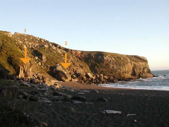
![The main bouldering rocks as seen from where the path meets the beach. 1) Warmup Wall 2) Main bouldering rock. Sand is at medium height at picture time.]()
[Hide Photo] The main bouldering rocks as seen from where the path meets the beach. 1) Warmup Wall 2) Main bouldering rock. Sand is at medium height at picture time.
![The cliffs of Fort Ross as seen from the pullout looking Southwest.]()
[Hide Photo] The cliffs of Fort Ross as seen from the pullout looking Southwest.


 Continue with onX Maps
 Continue with Facebook