
 Continue with onX Maps
 Continue with Facebook


Routes in Low Spark of High Wire Crag

|
I'll Be Back Crack T 5.9 5c 17 VI 17 HVS 5a |
|
|
May D&F T 5.4 4a 12 IV 10 VD 3c |
Order Wrong?
Sort Routes
| Type: | Trad, 70 ft (21 m) |
| FA: | Randy & Belen Carmichael, 9/16/2005 |
| Page Views: | 673 total · 3/month |
| Shared By: | Randy Carmichael on Sep 15, 2005 |
| Admins: | Leo Paik, John McNamee, Frances Fierst, Monty, Monomaniac, Tyler KC |
Your To-Do List:
Add To-Do ·
Your Star Rating:


Use onX Backcountry to explore the terrain in 3D, view recent satellite imagery, and more. Now available in onX Backcountry Mobile apps! For more information see this post.
 Access Issue: Seasonal Raptor Closures/CDOT Road Work
Details
Access Issue: Seasonal Raptor Closures/CDOT Road Work
Details
Please be aware of the annual raptor seasonal closures!
Raptor Closures Effective February 1-July 31
Visit: jeffco.us/open-space/news/2…
Tunnel 1 closure
For more details visit: jeffco.us/open-space/alerts…

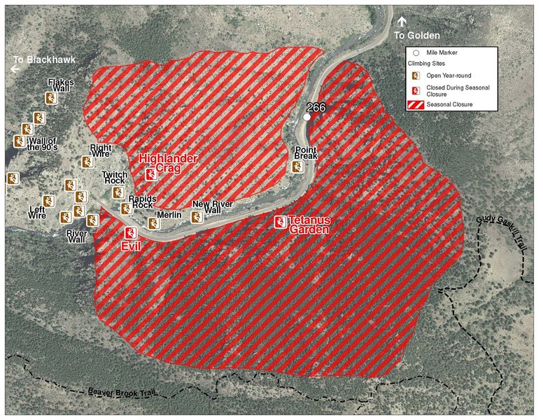
The two areas Jefferson County Open Space intends to close in Clear Creek Canyon, shown on the attached maps, encompass the active eagle nests. If the Clear Creek eagles continue to nest in the active nests, these areas will remain closed from February 1 through July 31. If the eagles choose different nesting sites, the closures will be adjusted accordingly to protect those eagles during their breeding season.
Currently, rock climbing areas that fall inside of the seasonal raptor closures include:
Blonde Formation
Bumbling Stock
Evil Area
Ghost Crag
Highlander
Skinny Legs
Stumbling Block
Tetanus Garden
Fault Caves
June 7, 2021 - TBD: Highway 6 is currently doing full road closures from Sunday night to Friday morning every week. The closure is from the junction of Highway 119 and Highway 6 to the junction of Highway 40 and Highway 6 (mile post ~260 to ~257). Vehicles that remain in the closure will be towed at owners expense.
Sundays: 7PM-4AM
Monday-Thursday: 4PM-4AM
Raptor Closures Effective February 1-July 31
Visit: jeffco.us/open-space/news/2…
Tunnel 1 closure
For more details visit: jeffco.us/open-space/alerts…
The two areas Jefferson County Open Space intends to close in Clear Creek Canyon, shown on the attached maps, encompass the active eagle nests. If the Clear Creek eagles continue to nest in the active nests, these areas will remain closed from February 1 through July 31. If the eagles choose different nesting sites, the closures will be adjusted accordingly to protect those eagles during their breeding season.
Currently, rock climbing areas that fall inside of the seasonal raptor closures include:
Blonde Formation
Bumbling Stock
Evil Area
Ghost Crag
Highlander
Skinny Legs
Stumbling Block
Tetanus Garden
Fault Caves
June 7, 2021 - TBD: Highway 6 is currently doing full road closures from Sunday night to Friday morning every week. The closure is from the junction of Highway 119 and Highway 6 to the junction of Highway 40 and Highway 6 (mile post ~260 to ~257). Vehicles that remain in the closure will be towed at owners expense.
Sundays: 7PM-4AM
Monday-Thursday: 4PM-4AM
Description

This is short, steep, and pumpy. The holds and pro are all there, but the question is if you can stay with it before the gas runs out.
This diagonal crack (left to right) faces north, is about 40 feet above the river, and can easily be seen from the bridge on the east side of Tunnel 2. Begin on the low angle arête near the edge of Clear Creek. Set an anchor for your belayer and climb over an easy shelf to the base of the crack. 30 feet of assorted finger, hand, and arm jams with a jug in between will get you to the top.
There is a large boulder on a grassy knoll about 15 feet above the top of the crack that can be slinged for an anchor, or there are some cracks available for the anchor 20 feet above the boulder. Be sure to consider the traversing nature of this climb for protecting the follower when setting your pro and anchor. Watch out for small pesky cacti at the top of the crack.
Descent: Head left (southwest) up the grassy knoll and 4th class up some easy rock to the base of High Wire Crag. Watch for loose rocks.
Location
From the bridge on the east side of the 2nd Tunnel, scramble down to the west side of the river. Hike along the west bank for about 200 feet. Boulder up to a large, sloping ledge. Scramble down the ledge towards the river at which point you can see the diagonal crack to the west and about 40 feet above you.


0 Comments