Continue with onX Maps
 Continue with Facebook


Ice Climbing in Smokey Mountain National Park
|
|
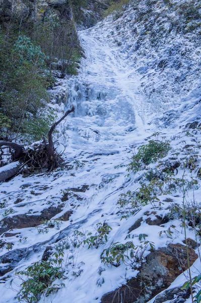
In the pure spirit of adventure and exploration, this year I've been scouting and climbing some ice routes in Smokey Mountain National Park along the NC/TN border. The area has the right ingredients, 1) Altitude, routes between 4800 and 6400ft 2)North facing - no sun at all 3)Colder than pretty much anywhere else in NC/TN and 4)Decent weather data available. |

|
is that northwest side of Charles Bunion? |
|
|
Kenneth Cole wrote:is that northwest side of Charles Bunion?Yes, there are a lot of hidden pitches of decent ice on that aspect of between Charlies Bunion and Mount Leconte. |
|
|
Josh, that's only a 3mi hike via the AT from 441. Do you think it is accessible from to the top to lower or rappel onto ice? There also looks to be steep rock gulley w water just under the Jumpoff where the Blvd Trail t's into the AT...have you investigated that?? |
|
|
Walking in from Newfound gap is what I've been doing looking for ice on the north facing aspect between Charlie's Bunion and Leconte. Ya it's 3 miles to the top of some routes but that's the easy part. Rappelling down any of the routes is not an option. You'd never find any of the gullies from above and rappelling down 2000ft of 50 degree gully would take forever. You gotta get down to leister prong and then hunt along there. I've bushwhacked down to the west of the jumpoff towards horseshoe mtn and then down to Leister creek or down the porter creek man way (google it). Once in the bottom, you gotta just sniff out any of the drainages heading back up towards the AT. Be warned, this is very wild terrain for this area. It has some of the thickest, steepest, bush wacking I have ever encountered. Phones don't work, GPS gets confused and looses accuracy. When your retreat option is to just keep going up to get back to the trail, your options are limited if something goes wrong. The ice I have found isn't particularly fantastic, but the adventure is worth it. |