
 Continue with onX Maps


ID 111734604 ·
·
Copyright Violation?


Rate Photo

 5.0
from
1 vote
5.0
from
1 vote
Eugenel Espiritu
Mar 29, 2016
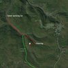
“Map to get to site. The clearing is marked to show where you might want to start bushwacking. Both lots are connected by limestone run road; the fireroad from both lots meets at a stream near a bridge. At that point continue east 50ft then continue onto a trail South Southeast heading uphill. Two mile hike from lower parking area all uphill; a little more than a two mile hike from upper downhill then uphill after you hit the stream. See picture of clearing to see where to begin bushwack.”


0 Comments