
 Continue with onX Maps


ID 111155887 ·
·
Copyright Violation?


Rate Photo


 3.8
from
4 votes
3.8
from
4 votes
Nick Esker
Oct 13, 2015
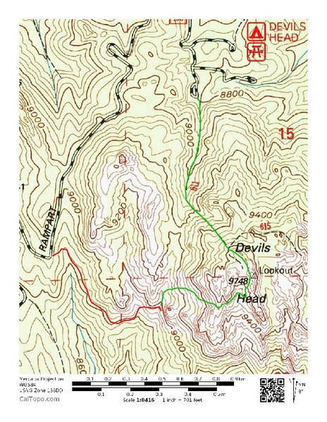
“Approach map. Red shows the easiest approach to Jungle Wall. Green shows the approach we took in by trying to follow the currently posted approach descriptions, in conjunction with the comments here.
If you try to follow the approach instructions on this page, you will hike at least an extra mile and several hundred more vertical feet up and down, bushwhacking, in ridiculously difficult route finding terrain. The directions deposit you far, far from the Jungle Wall with no further discernible directions.
It took us 2.5 hours to find the Jungle Wall on our way in (green). It took about 30 minutes to hike out via the red trail, where we should have parked. There is a great climber's trail that contours above the drainage on the backside of Wipeyur Buttress, then traverses east below Wipeyur Buttress/slabs to reach the gully draining Wipeyur Buttress, Jungle, Training Grounds, etc. It's a short hike to the base from here.
Save yourself the effort, and park at the small pullout on Rampart Range Road around 8,940' before the road takes a hard turn west and then northwest prior to a hairpin turn. This is practically the same approach information on Wipeyur Buttress' page.”


1 Comment